
-
Federal
China Dimensions Data Collection: China County-Level Data from Provincial Economic Yearbooks, Keyed to 1:1M GIS Map
National Aeronautics and Space Administration —
The China County-Level Data on Provincial Economic Yearbooks, Keyed To 1:1M GIS Map consists of socioeconomic and boundary data for the administrative regions of... -
Federal
2008 Environmental Performance Index (EPI)
National Aeronautics and Space Administration —
The 2008 Environmental Performance Index (EPI) centers on two broad environmental protection objectives: (1) reducing environmental stresses on human health, and (2)... -
Federal
USGS Antarctic Single Frame Records
National Aeronautics and Space Administration —
Antarctic Single Frame Records are a collection of aerial photographs over Antarctica from the United States Antarctic Resource Center (USARC) and the British... -
Federal
Pilot 2006 Environmental Performance Index (EPI)
National Aeronautics and Space Administration —
The Pilot 2006 Environmental Performance Index (EPI) centers on two broad environmental protection objectives: (1) reducing environmental stresses on human health,... -
Federal
Giant Metrewave Radio Telescope 150-MHz Survey of Kepler K2 Field 1
National Aeronautics and Space Administration —
This table contains some of the results from the first dedicated radio continuum survey of a Kepler K2 mission field, Field 1, covering the North Galactic Cap. The... -
Federal
NASA Landsat Data Collection
National Aeronautics and Space Administration —
The NASA Landsat Data Collection (NLDC) is a compilation of Landsat multispectral scanner (MSS) scenes and Landsat thematic mapper (TM) scenes. This compilation of... -
Federal
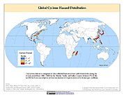
Global Cyclone Hazard Frequency and Distribution
National Aeronautics and Space Administration —
The Global Cyclone Hazard Frequency and Distribution is a 2.5 minute grid based on more than 1,600 storm tracks for the period 1 January 1980 through 31 December 2000... -
Federal
IceBridge Photon Counting Lidar L1B Subset Geolocated Photon Elevations V001
National Aeronautics and Space Administration —
This data set contains nadir photon counting data captured over Antarctica using the Sigma Space photon counting lidar. Position and orientation data are included.... -
Federal
Natural Resource Protection and Child Health Indicators, 2015 Release
National Aeronautics and Space Administration —
The Natural Resource Protection and Child Health Indicators, 2015 Release, are produced in support of the U.S. Millennium Challenge Corporation as selection criteria... -
Federal
Aerial Photographs (from AMES Pilot Land Data System); USGS EDC, Sioux Falls
National Aeronautics and Space Administration —
The aerial photography inventoried by the Pilot Land Data System (PLDS) at NASA AMES Research Center has been transferred to the USGS EROS Data Center. The photos... -
Federal
Characteristics of African Savanna Biomes for Determining Woody Cover
National Aeronautics and Space Administration —
This data set includes the soil and vegetation characteristics, herbivore estimates, and precipitation measurement data for the 854 sites described and analyzed in... -
Federal
CARVE: Alaskan Fire Emissions Database (AKFED), 2001-2013
National Aeronautics and Space Administration —
This data set provides estimates of annual carbon emissions (kg carbon per square meter) from boreal fires at 450-m resolution for the state of Alaska between 2001... -
Federal
Murchison Widefield Array Low-Frequency Radio Survey of Kepler K2 Field 1
National Aeronautics and Space Administration —
This table contains some of the results from the first dedicated radio continuum survey of a Kepler K2 mission field, Field 1, covering the North Galactic Cap. The... -
Federal
LMOS Wisconsin Department of Natural Resources (WDNR) Routine Ground Site Data
National Aeronautics and Space Administration —
LMOS_Ground_WDNRRoutine_Data_1 is the Lake Michigan Ozone Study (LMOS) ground site data collected at the Wisconsin Department of Natural Resources (WDNR) Routine... -
Federal
Global Soil Profile Data (ISRIC-WISE)
National Aeronautics and Space Administration —
The International Soil Reference and Information Centre-World Inventory of Soil Emission Potentials (ISRIC-WISE) international soil profile data set consists of a... -
Federal
Natural Resource Management Index (NRMI), 2011 Release
National Aeronautics and Space Administration —
The Natural Resource Management Index (NRMI), 2011 Release is a composite index for 174 countries derived from the average of four proximity-to-target indicators for... -
Federal
Methane Plumes Derived from AVIRIS-NG over Point Sources across California, 2016-2017
National Aeronautics and Space Administration —
This dataset provides maps of methane (CH4) plumes along flight lines over identified methane point-source emitting infrastructure across the State of California, USA... -
Federal
Natural Resource Protection and Child Health Indicators, 2021 Release
National Aeronautics and Space Administration —
The Natural Resource Protection and Child Health Indicators, 2021 Release, is produced in support of the U.S. Millennium Challenge Corporation (MCC) as selection... -
Federal
Natural Resources Conservation Service SD State Farm Service Agency Color Slide Scans
National Aeronautics and Space Administration —
The unique landscape of South Dakota, known for its diverse wetlands and large areas of native prairie, provides critical habitat for many of the nation’s migratory... -
Federal
Natural Resource Protection and Child Health Indicators, 2017 Release
National Aeronautics and Space Administration —
The Natural Resource Protection and Child Health Indicators, 2017 Release, is produced in support of the U.S. Millennium Challenge Corporation (MCC) as selection...

Official websites use .gov
A
.gov website belongs to an official government
organization in the United States.
Secure .gov websites use HTTPS
A
lock (
) or https:// means you’ve safely connected to
the .gov website. Share sensitive information only on official,
secure websites.