
-
Federal
Lunar Map Catalog
National Aeronautics and Space Administration —
The Lunar Map Catalog includes various maps of the moon's surface, including Apollo landing sites; earthside, farside, and polar charts; photography index maps; zone... -
Federal
Satellite Observations of Arctic Change, Version 1
National Aeronautics and Space Administration —
The purpose of this site is to expose NASA satellite data and research on Arctic change in the form of maps that illustrate the changes taking place in the Arctic... -
Federal
High-Resolution QuickBird Imagery and Related GIS Layers for Barrow, Alaska, USA, Version 1
National Aeronautics and Space Administration —
This data set contains high-resolution QuickBird imagery and geospatial data for the entire Barrow QuickBird image area (156.15° W - 157.07° W, 71.15° N - 71.41° N)... -
Federal
BARREL 1G X-ray Spectrometer (FSPC) Bremsstrahlung X-ray Spectrum Fast Time Resolution, Level 2, 0.05 s Data
National Aeronautics and Space Administration —
FSPC: Four channels of fast time resolution, 50 ms, Bremsstrahlung X-ray spectra detected with a NaI Scintillator. Each channel is separated in its own variable:... -
Federal
Global Vegetation Greenness (NDVI) from AVHRR GIMMS-3G+, 1981-2022
National Aeronautics and Space Administration —
This dataset holds the Global Inventory Modeling and Mapping Studies-3rd Generation V1.2 (GIMMS-3G+) data for the Normalized Difference Vegetation Index (NDVI). NDVI... -
Federal
CORONA Satellite Photographs from the U.S. Geological Survey
National Aeronautics and Space Administration —
The first generation of U.S. photo intelligence satellites collected more than 860,000 images of the Earth’s surface between 1960 and 1972. The classified military... -
Federal
KORUS-AQ Miscellaneous Data
National Aeronautics and Space Administration —
KORUSAQ_Miscellaneous_Data are miscellaneous ancillary files collected during the KORUS-AQ field campaign. This product includes data collected onboard the UMD Cessna... -
Federal
VIIRS/NPP Burned Area Monthly L4 Global 500m SIN Grid V002
National Aeronautics and Space Administration —
The daily NASA/NOAA Suomi National Polar-orbiting Partnership (Suomi NPP) Visible Infrared Imaging Radiometer Suite (VIIRS) Burned Area (VNP64A1) Version 2 data... -
Federal
VIIRS/NPP Snow Cover 6-Min L2 Swath 375m V002
National Aeronautics and Space Administration —
This data set reports snow cover using radiance data acquired by the Visible Infrared Imager Radiometer Suite (VIIRS) on board the Suomi National Polar-orbiting... -
Federal
MODIS/Terra+Aqua Land Cover Type Yearly L3 Global 0.05Deg CMG V061
National Aeronautics and Space Administration —
The Terra and Aqua combined Moderate Resolution Imaging Spectroradiometer (MODIS) Land Cover Climate Modeling Grid (CMG) (MCD12C1) Version 6.1 data product provides a... -
Federal
BARREL 3C X-ray Spectrometer (SSPC) Bremsstrahlung X-ray Spectrum Slow Time Resolution, Level 2, 32 s Data
National Aeronautics and Space Administration —
SSPC: 256 channels of slow time resolution, 32 s, Bremsstrahlung X-ray spectra detected with a NaI Scintillator. The nominal energy range covered by the 256 channels... -
Federal
Borehole and environmental protection descriptive and numerical data, Yamal Peninsula, Russia, Version 1
National Aeronautics and Space Administration —
This database of selected borehole records from the Yamal Peninsula, Russia, contains environmental descriptions (textual and numerical) of the units on the index... -
Federal
KORUS-AQ Ozonesonde Data
National Aeronautics and Space Administration —
KORUSAQ_Sondes_Data features data collected via ozonesonde launches at Olympic Park and Taehwa during the KORUS-AQ field campaign. Data collection for this product is... -
Federal
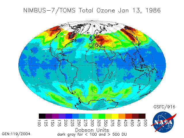
TOMS Nimbus-7 Total Ozone Aerosol Index UV-Reflectivity UV-B Erythemal Irradiances Daily L3 Global 1 deg x 1.25 deg V008 (TOMSN7L3) at GES DISC
National Aeronautics and Space Administration —
The Nimbus-7 Total Ozone Mapping Spectrometer (TOMS) version 8 daily global gridded data product contains total column ozone, UV aerosol index, Lambertian effective... -
Federal
Last of the Wild Project, Version 2, 2005 (LWP-2): Global Human Footprint Dataset (Geographic)
National Aeronautics and Space Administration —
The Global Human Footprint Dataset of the Last of the Wild Project, Version 2, 2005 (LWP-2) is the Human Influence Index (HII) normalized by biome and realm. The HII... -
Federal
Sentinel-5P TROPOMI Methane CH4 1-Orbit L2 7km x 7km V1 (S5P_L2__CH4___) at GES DISC
National Aeronautics and Space Administration —
Starting from August 6th in 2019, Sentinel-5P TROPOMI along-track high spatial resolution (~5.5km at nadir) has been implemented. For data after August 6th of 2019,... -
Federal
ISLSCP II Ecosystem Rooting Depths
National Aeronautics and Space Administration —
The goal of this study was to predict the global distribution of plant rooting depths based on data about global aboveground vegetation structure and climate.... -
Federal
2015 Urban Extents from VIIRS and MODIS for the Continental U.S. Using Machine Learning Methods NGDA
National Aeronautics and Space Administration —
The 2015 Urban Extents from VIIRS and MODIS for the Continental U.S. Using Machine Learning Methods data set models urban settlements in the Continental United States... -
Federal
Compendium of Environmental Sustainability Indicator Collections: 2004 Environmental Vulnerability Index (EVI)
National Aeronautics and Space Administration —
The 2004 Environmental Vulnerability Index (EVI) portion of the Compendium of Environmental Sustainability Indicator Collections contains 111 variables for 235... -
Federal
Thematic Mapper (TM) Mosaics (1984-1997)
National Aeronautics and Space Administration —
Mosaic data products, which are also available for Tri-Decadal Global Landsat Orthorectified TM and ETM+ Pan-sharpened data, and may be searched and downloaded...

Official websites use .gov
A
.gov website belongs to an official government
organization in the United States.
Secure .gov websites use HTTPS
A
lock (
) or https:// means you’ve safely connected to
the .gov website. Share sensitive information only on official,
secure websites.