
-
Federal
Global Flood Hazard Frequency and Distribution
National Aeronautics and Space Administration —
The Global Flood Hazard Frequency and Distribution is a 2.5 minute grid derived from a global listing of extreme flood events between 1985 and 2003 (poor or missing... -
Federal
GPM Ground Validation National Mosaic and Multi-Sensor QPE (NMQ) System IFloodS V1
National Aeronautics and Space Administration —
The GPM Ground Validation National Mosaic and Multi-Sensor QPE (NMQ) System IFloodS dataset contains quality control products, real time rain rate estimates, hourly... -
Federal
MODIS/Aqua+Terra Global Flood Product L3 NRT 250m
National Aeronautics and Space Administration —
The MODIS/Aqua+Terra Global Flood Product L3 Near Real Time (NRT) 250m Global Flood Product (MCDWD_L3_NRT) (beta) provides daily maps of flooding globally. The... -
Federal
Global Multihazard Frequency and Distribution
National Aeronautics and Space Administration —
The Global Multihazard Frequency and Distribution is a 2.5 minute grid presenting a simple multihazard index based solely on summated single-hazard decile values. The... -
Federal
GPM GROUND VALIDATION MET ONE RAIN GAUGE PAIRS IFLOODS V2
National Aeronautics and Space Administration —
The GPM Ground Validation Met One Rain Gauge Pairs IFloodS V2 data measures the amount of fallen precipitation collected by a Model 380 tipping bucket rain gauge made... -
Federal
Geocoded Disasters (GDIS) Dataset
National Aeronautics and Space Administration —
The Geocoded Disasters (GDIS) Dataset is a geocoded extension of a selection of natural disasters from the Centre for Research on the Epidemiology of Disasters'... -
Federal
GPM Ground Validation Hydro-Estimator IFloodS V1
National Aeronautics and Space Administration —
The GPM Ground Validation Hydro-Estimator IFloodS dataset contains rainfall rate estimates derived using NOAA’s Geostationary Operational Environmental Satellites... -
Federal
Global Multihazard Mortality Risks and Distribution
National Aeronautics and Space Administration —
The Global Multihazard Mortality Risks and Distribution is a 2.5 minute grid identifying and characterizing the nature of multihazard risk at the global scale. For... -
Federal
High Mountain Asia Multitemporal Landslide Inventory for the Pumqu/Arun River Basin V001
National Aeronautics and Space Administration —
The transboundary Pumpqu/Arun River basin spreads across Nepal and Tibet. Nearly 95% of the basin lies in Tibet through which the Pumpqu River flows. The river is... -
Federal
LBA-ECO LC-04 THMB Model Simulations for the Amazon and Tocantins Basins: 1939-1998
National Aeronautics and Space Administration —
The model output data provided were generated by the THMB 1.2 (Terrestrial Hydrology Model with Biogeochemistry) model which simulates the flow of water through... -
Federal
LBA-ECO LC-07 CO2 and CH4 Flux from Wetlands, Negro River Basin, Brazil: 2004-2006
National Aeronautics and Space Administration —
This data set provides estimates of daily and monthly carbon dioxide (CO2) and methane (CH4) diffusive and ebullitive flux for dry and flooded areas from two study... -
Federal
Land Use and Cover Maps from Landsat, Mawas, Central Kalimantan, Indonesia, 1994-2019
National Aeronautics and Space Administration —
This dataset contains annual land use/cover (LUC) maps at 30 m resolution across Mawas, Central Kalimantan, Indonesia. There are six files, each representing a five-... -
Federal
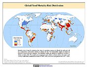
Global Flood Mortality Risks and Distribution
National Aeronautics and Space Administration —
The Global Flood Mortality Risks and Distribution is a 2.5 minute grid of global flood mortality risks. Gridded Population of the World, Version 3 (GPWv3) data... -
Federal
Groundswell Spatial Population and Migration Projections at One-Eighth Degree According to SSPs and RCPs, 2010-2050
National Aeronautics and Space Administration —
The Groundswell Spatial Population and Migration Projections at One-Eighth Degree According to SSPs and RCPs, 2010-2050, data set provides a baseline population... -
Federal
GPM GROUND VALIDATION NEXRAD LEVEL II KDVN IFLOODS V1
National Aeronautics and Space Administration —
The GPM Ground Validation Next Generation Weather Radar (NEXRAD) Level II IFloodS datasets were collected from four sites (see Table 1) from March 29, 2013 to June... -
Federal
SMALL SOLAR SYSTEM OBJECTS SPECTROSCOPIC SURVEY V1.0
National Aeronautics and Space Administration —
This dataset contains the visible spectra of 820 asteroids obtained between November 1996 and May 2001 at the 1.52m telescope at ESO (La Silla). The useful spectral... -
Federal
NPP Cropland: Gridded Estimates For the Central USA, 1982-1996, R1
National Aeronautics and Space Administration —
This data set contains a single data file (.csv format) that provides gridded values of net primary productivity (NPP) for cropland in eight counties in the central... -
Federal
SWOT Level 2 Water Mask Pixel Cloud Data Product, Version D
National Aeronautics and Space Administration —
The SWOT Level 2 Water Mask Pixel Cloud Product (SWOT_L2_HR_PIXC_D) provides high-resolution, geolocated observations of terrestrial surface water pixels detected by... -
Federal
Global Multihazard Total Economic Loss Risk Deciles
National Aeronautics and Space Administration —
The Global Multihazard Total Economic Loss Risk Deciles is a 2.5 minute grid of global multihazard total economic loss risks. First, for each of the considered... -
Federal
High Mountain Asia 30m and 8m Flood Geomorphic Potential V001
National Aeronautics and Space Administration —
This data set contains Flood Geomorphic Potential (FGP) at 30 m resolution for the High Mountain Asia region and 8 m resolution over Nepal. FGP is a digital elevation...

Official websites use .gov
A
.gov website belongs to an official government
organization in the United States.
Secure .gov websites use HTTPS
A
lock (
) or https:// means you’ve safely connected to
the .gov website. Share sensitive information only on official,
secure websites.