
-
Federal
Shuttle Radar Topography Mission (SRTM) Images
National Aeronautics and Space Administration —
Culminating more than four years of processing data, NASA and the National Geospatial-Intelligence Agency (NGA) have completed Earth's most extensive global... -
Federal
Maps of Vegetation Types and Physiographic Features, Imnavait Creek, Alaska
National Aeronautics and Space Administration —
This dataset provides the spatial distribution of vegetation types, soil carbon, and physiographic features in the Imnavait Creek area, Alaska. Specific attributes... -
Federal
VLA Hubble Deep Field 20-cm Source Catalog
National Aeronautics and Space Administration —
The authors have conducted a deep radio survey with the Very Large Array (VLA) at 1.4 GHz of a region containing the Hubble Deep Field (HDF). This survey overlaps... -
Federal
China Dimensions Data Collection: Fundamental GIS: Digital Chart of China, 1:1M, Version 1
National Aeronautics and Space Administration —
The Fundamental GIS: Digital Chart of China, 1:1M, Version 1 consists of vector maps of China and surrounding areas. The maps include roads, railroads, drainage... -
Federal
Extremely Luminous X-Ray Source Candidates Catalog
National Aeronautics and Space Administration —
Using Chandra archive data, the authors conducted a thorough survey of luminous X-ray sources. They directly analyzed about 9400 Chandra ACIS observations and cross-... -
Federal
BOREAS DEM Data over the NSA-MSA and SSA-MSA in AEAC Projection
National Aeronautics and Space Administration —
These data were derived from the original DEMs produced by the BOREAS HYD-08 team. The original DEMs were in the UTM projection, while this product is projected in... -
Federal
LBA-ECO LC-01 Topographic Data for Intensive Study Areas, Northern Ecuadorian Amazon
National Aeronautics and Space Administration —
This data set contains topographic/geomorphological data associated with the four Intensive Study Areas (ISAs) in the Northern Ecuadorian Amazon (northern Oriente)... -
Federal
BOREAS Elevation Contours over the NSA and SSA ARC/Info Generate Format
National Aeronautics and Space Administration —
This data set was prepared by BORIS staff by reformatting the original data into the ARC/INFO Generate format. The original data were received in SIF at a scale of... -
Federal
CGRO/EGRET Revised Catalog of Gamma-Ray Sources
National Aeronautics and Space Administration —
The CGRO/EGRET Revised Catalog of Gamma-Ray Sources (EGR) is a catalog of point gamma-ray sources detected by the EGRET detector on the Compton Gamma Ray Observatory.... -
Federal
TRMM Ground Validation Radar Site 3D Rain Map L3 1 month 2 km V7 (TRMM_3A55) at GES DISC
National Aeronautics and Space Administration —
The 3A55, 'Monthly 3-D Structure', provides radar site monthly 3-D structure information obtained from 2A55. The 2A55 'Radar Site 3-D Reflectivities', is composed of... -
Federal
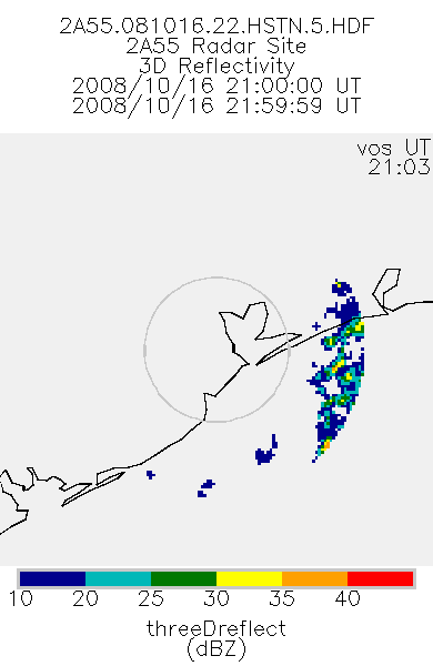
TRMM Ground Validation Radar Site 3D Reflectivity L2 1 hour V7 (TRMM_2A55) at GES DISC
National Aeronautics and Space Administration —
'Radar Site 3-D Reflectivities', is composed of 3 different fields. The first field has an array of 3-D reflectivities in Cartesian coordinates with a 2 km horizontal... -
Federal
M 33 XMM-Newton Supernova Remnants Catalog
National Aeronautics and Space Administration —
The authors of this catalog carried out a study of the X-ray properties of the supernova remnant (SNR) population in M 33 with XMM-Newton, comprising deep... -
Federal
Chandra Source Catalog, v2.1.1
National Aeronautics and Space Administration —
The Chandra Source Catalog (CSC) is the definitive catalog of X-ray sources detected by the Chandra X-ray Observatory. By combining Chandra's sub-arcsecond on-axis... -
Federal
CG 12 Chandra X-Ray Point Source Catalog
National Aeronautics and Space Administration —
The mysterious high Galactic latitude cometary globule CG 12 has been observed with the ACIS detector on board the Chandra X-Ray Observatory. 128 X-ray sources are... -
Federal
SCAMS/Nimbus-6 Images of Brightness Temperatures, Water Vapor and Temperature on 70-mm Film V001 (SCAMSN6IM) at GES DISC
National Aeronautics and Space Administration —
The SCAMSN6IM data product consists of images of brightness temperatures, water vapor and temperature on 70 mm film strips from the Nimbus-6 Scanning Microwave... -
Federal
EXOSAT/ME Galactic Plane Survey
National Aeronautics and Space Administration —
This catalog is based on information contained in Warwick et al (1988), MNRAS, 232, 551. The distribution of 2-6 keV x-ray emission in the galactic plane in the first... -
Federal
M 83 Chandra X-Ray Point Source Catalog
National Aeronautics and Space Administration —
The authors of this table have obtained a series of deep X-ray images of the nearby (4.61 Mpc) galaxy M 83 using Chandra, with a total exposure of 729 ks. Combining... -
Federal
BOREAS HYD-08 DEM Data over the NSA-MSA and SSA-MSA in UTM Projection
National Aeronautics and Space Administration —
These DEMs were produced from digitized contours at a cell resolution of 100 meters. Vector contours of the area were used as input to a software package that... -
Federal
Giant Metrewave Radio Telescope 1h XMM/Chandra Survey Fld 610-MHz Source Catalog
National Aeronautics and Space Administration —
This table contains the results of a deep 610-MHz survey of the 1hr XMM-Newton/Chandra survey area with the Giant Metre-wave Radio Telescope (GMRT). The resulting... -
Federal
High-Resolution Radar Imagery, Digital Elevation Models, and Related GIS Layers for Barrow, Alaska, USA, Version 1
National Aeronautics and Space Administration —
This product set contains high-resolution Interferometric Synthetic Aperture Radar (IFSAR) imagery and geospatial data for the Barrow Peninsula (155.39 - 157.48 deg...

Official websites use .gov
A
.gov website belongs to an official government
organization in the United States.
Secure .gov websites use HTTPS
A
lock (
) or https:// means you’ve safely connected to
the .gov website. Share sensitive information only on official,
secure websites.