
-
Federal
MOPITT Beta Derived CO (Near and Thermal Infrared Radiances) V109
National Aeronautics and Space Administration —
MOP02J_109 is the Measurements Of Pollution In The Troposphere (MOPITT) Beta Derived Carbon Monoxide (CO) (Near and Thermal Infrared Radiances) version 109 product.... -
Federal
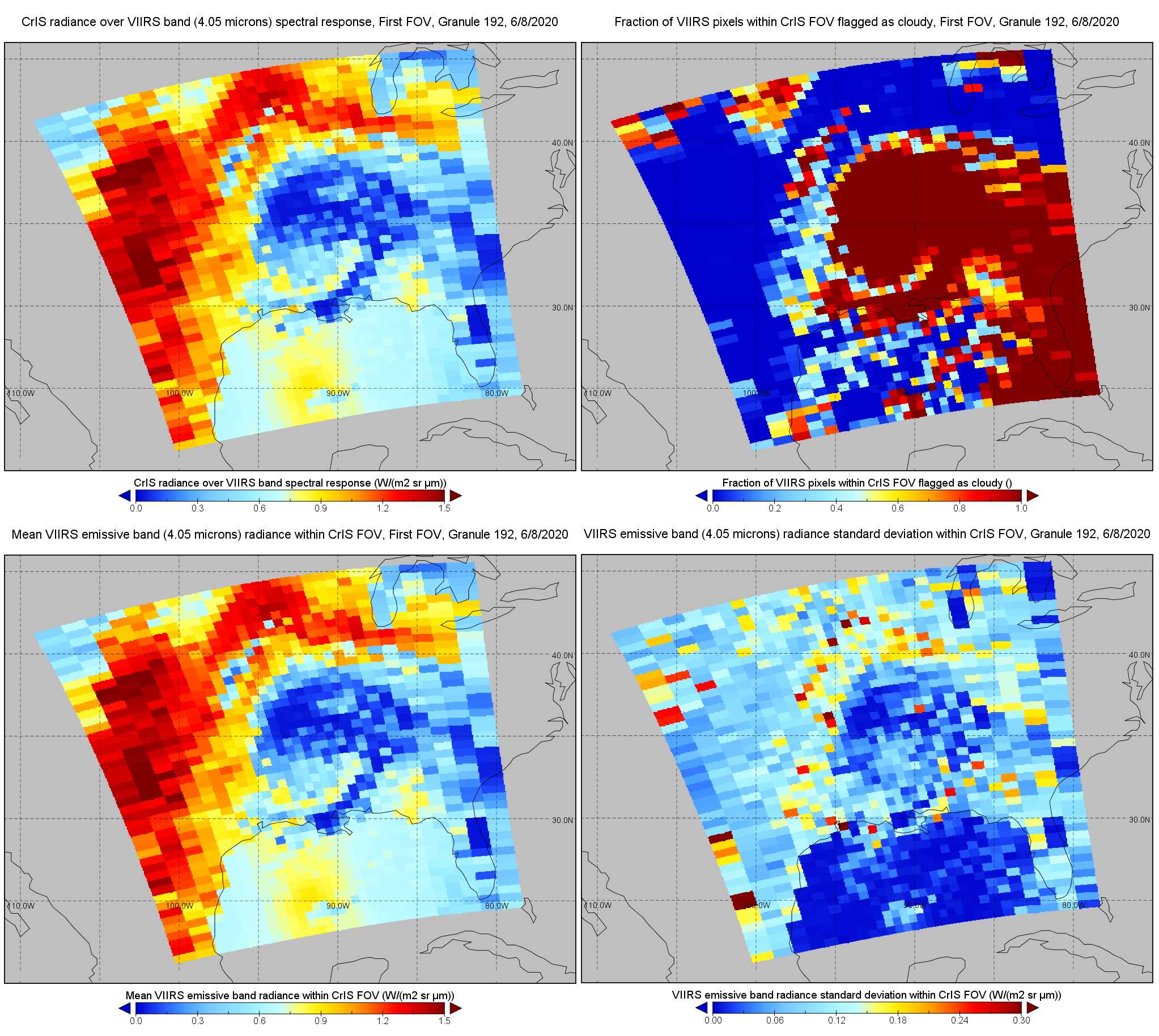
S-NPP CrIS IMG: Collocated VIIRS level 1 / cloud mask statistical summary V2 (SNDRSNCrISL1BIMG) at GES DISC
National Aeronautics and Space Administration —
The Cross-track Infrared Sounder (CrIS) Level 1B Normal Spectral Resolution (NSR) data files contain radiance measurements along with ancillary spacecraft,... -
Federal
GPM SSM/I on F14 (GPROF) Climate-based Radiometer Precipitation Profiling L2 1.5 hours 12 km V07 (GPM_2AGPROFF14SSMI_CLIM) at GES DISC
National Aeronautics and Space Administration —
Version 07 is the current version of the data set. Older versions will no longer be available and have been superseded by Version 07.The 'CLIM' products differ from... -
Federal
MOPITT Beta CO gridded daily means (Near Infrared Radiances) V109
National Aeronautics and Space Administration —
MOP03N_109 is the Measurements of Pollution in the Troposphere (MOPITT) Beta CO gridded daily means (Near Infrared Radiances) version 109 product. It is a non-... -
Federal
GPM MHS on METOP-B (GPROF) Radiometer Precipitation Profiling L2A 1.5 hours 17 km V07 (GPM_2AGPROFMETOPBMHS) at GES DISC
National Aeronautics and Space Administration —
Version 07 is the current version of the data set. Older versions will no longer be available and have been superseded by Version 07. The 2AGPROF (also known as, GPM... -
Federal
GPM ATMS on NOAA-21 (GPROF) Climate-based Radiometer Precipitation Profiling L2A 1.5 hours 17 km V07 (GPM_2AGPROFNOAA21ATMS_CLIM) at GES DISC
National Aeronautics and Space Administration —
Version 07 is the current version of the data set. The "CLIM" products differ from their "regular" counterparts (without the "CLIM" in the name) by the ancillary data... -
Federal
GPM SSMIS on F16 (GPROF) Climate-based Radiometer Precipitation Profiling 1.5 hours 12 km V07 (GPM_2AGPROFF16SSMIS_CLIM) at GES DISC
National Aeronautics and Space Administration —
Version 07 is the current version of the data set. Older versions will no longer be available and have been superseded by Version 07.The 'CLIM' products differ from... -
Federal
GPM SSMIS on F17 (GPROF) Climate-based Radiometer Precipitation Profiling 1.5 hours 12 km V07 (GPM_2AGPROFF17SSMIS_CLIM) at GES DISC
National Aeronautics and Space Administration —
Version 07 is the current version of the data set. Older versions will no longer be available and have been superseded by Version 07.The 'CLIM' products differ from... -
Federal
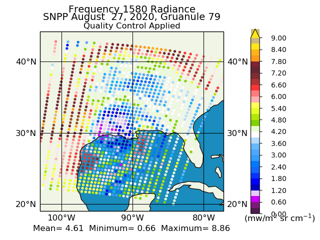
Suomi NPP CrIS Level 1B Full Spectral Resolution V3 (SNPPCrISL1B) at GES DISC
National Aeronautics and Space Administration —
The Cross-track Infrared Sounder (CrIS) Level 1B Full Spectral Resolution (FSR) data files contain radiance measurements along with ancillary spacecraft, instrument,... -
Federal
Classification
National Aeronautics and Space Administration —
A supervised learning task involves constructing a mapping from an input data space (normally described by several features) to an output space. A set of training... -
Federal
GPM ATMS on NOAA-20 (GPROF) Radiometer Precipitation Profiling L2A 1.5 hours 17 km V07 (GPM_2AGPROFNOAA20ATMS) at GES DISC
National Aeronautics and Space Administration —
Version 07 is the current version of the data set. The 2AGPROF (also known as, GPM GPROF (Level 2)) algorithm retrieves consistent precipitation and related science... -
Federal
IBEX High Energy Neutral Atom Imager (ENA-Hi) Data Release 10, Compton-Getting corrected, Survival Probability corrected, Ram direction, West Longitude Ecliptic Maps, 1 year averaged data, Level H3
National Aeronautics and Space Administration —
This IBEX-Hi data set is from Release 10 of all-sky map data for the first seven years, 2009-2015, in the form of ram direction Hydrogen, H, energetic neutral atom... -
Federal
IBEX High Energy Neutral Atom Imager (ENA-Hi) Data Release 10, not Compton-Getting corrected, not Survival Probability corrected, Antiram direction, West Longitude Ecliptic Maps, Level H3 (H3), 7 year average Data
National Aeronautics and Space Administration —
The IBEX ENA-Hi and IBEX ENA-Lo data sets are from Release 10 of all-sky map data for the first seven years, 2009-2015, in the form of antiram direction Hydrogen, H,... -
Federal
IBEX High Energy Neutral Atom Imager (ENA-Hi) Data Release 10, Compton-Getting corrected, not Survival Probability corrected, Omnidirectional, West Longitude Ecliptic Maps, Level H3 (H3), 7 year average Data
National Aeronautics and Space Administration —
The IBEX ENA-Hi and IBEX ENA-Lo data sets are from Release 10 of all-sky map data for the first seven years, 2009-2015, in the form of omni direction Hydrogen, H,... -
Federal
MOPITT CO gridded daily means (Near and Thermal Infrared Radiances) V009
National Aeronautics and Space Administration —
MOP03J_9 is the Measurements Of Pollution In The Troposphere (MOPITT) Carbon Monoxide (CO) gridded daily means (Near and Thermal Infrared Radiances) version 9 data... -
Federal
Local L2 Thresholding Based Data Mining in Peer-to-Peer Systems
National Aeronautics and Space Administration —
In a large network of computers, wireless sensors, or mobile devices, each of the components (hence, peers) has some data about the global status of the system. Many... -
Federal
AfriSAR: Aboveground Biomass for Lope, Mabounie, Mondah, and Rabi Sites, Gabon
National Aeronautics and Space Administration —
This dataset provides gridded estimates of aboveground biomass (AGB) for four sites in Gabon at 0.25 ha (50 m) resolution derived with field measurements and airborne... -
Federal
An Adaptive Recurrent Neural Network for Remaining Useful Life Prediction of Lithium-ion Batteries
National Aeronautics and Space Administration —
Prognostics is an emerging science of predicting the health condition of a system (or its components) based upon current and previous system states. A reliable... -
Federal
Cosmic Dust Catalog
National Aeronautics and Space Administration —
Since May 1981, the National Aeronautics and Space Administration (NASA) has used aircraft to collect cosmic dust (CD) particles from Earth's stratosphere. Specially... -
Federal
SORCE SOLSTICE FUV and MUV Level 3 Solar Spectral Irradiance 0.1nm Res 24-Hour Means V018 (SOR3SOLD_HIGH) at GES DISC
National Aeronautics and Space Administration —
SORCE SOLSTICE FUV and MUV Level 3 Solar Spectral Irradiance 0.1nm Res 24-Hour Means data product (SOR3SOLD_HIGH) is constructed using measurements from the SOLSTICE...

Official websites use .gov
A
.gov website belongs to an official government
organization in the United States.
Secure .gov websites use HTTPS
A
lock (
) or https:// means you’ve safely connected to
the .gov website. Share sensitive information only on official,
secure websites.