
-
Federal
ASTER Global Digital Elevation Model V003
National Aeronautics and Space Administration —
The Terra Advanced Spaceborne Thermal Emission and Reflection Radiometer (ASTER) Global Digital Elevation Model (GDEM) Version 3 (ASTGTM) provides a global digital... -
Federal
ASTER Global Digital Elevation Model NetCDF V003
National Aeronautics and Space Administration —
The Terra Advanced Spaceborne Thermal Emission and Reflection Radiometer (ASTER) Global Digital Elevation Model (GDEM) Version 3 (ASTGTM) provides a global digital... -
Federal
MISR Level 1B2 Ellipsoid Data V004
National Aeronautics and Space Administration —
MI1B2E_004 is the Multi-angle Imaging SpectroRadiometer (MISR) Level 1B2 Ellipsoid Data Version 4 product. It contains Ellipsoid-projected Top-of-Atmosphere (TOA)... -
Federal
NACP Site: Terrestrial Biosphere Model Output Data in Original Format
National Aeronautics and Space Administration —
This data set contains the original model output data submissions from the 24 terrestrial biosphere models (TBM) that participated in the North American Carbon... -
Federal
NACP Site: Terrestrial Biosphere Model and Aggregated Flux Data in Standard Format
National Aeronautics and Space Administration —
This data set provides standardized output variables for gross primary productivity (GPP), net ecosystem exchange (NEE), leaf area index (LAI), ecosystem respiration... -
Federal
MISR Level 3 Component Global Aerosol Product covering a quarter (seasonal) V004
National Aeronautics and Space Administration —
MIL3QAE_004 is the Multi-angle Imaging SpectroRadiometer (MISR) Level 3 Component Global Aerosol Product covering a quarter (seasonal) version 4. It contains a... -
Federal
MISR Level 3 Component Global Aerosol Product covering a year V004
National Aeronautics and Space Administration —
MIL3YAE_004 is the Multi-angle Imaging SpectroRadiometer (MISR) Level 3 Component Global Aerosol Product covering a year version 4 data product. It contains a... -
Federal
First ISCCP Regional Experiment (FIRE) Atlantic Stratocumulus Transition Experiment (ASTEX) University of Washington C-131A Discrete Data
National Aeronautics and Space Administration —
The First ISCCP Regional Experiments have been designed to improve data products and cloud/radiation parameterizations used in general circulation models (GCMs).... -
Federal
MISR Level 3 Component Global Land Regional public Product covering a month V002
National Aeronautics and Space Administration —
MI3MLSR_2 is the Multi-angle Imaging SpectroRadiometer (MISR) Level 3 Component Global Land Regional public Product covering a month version 2. It contains a daily... -
Federal
ASTER Global Digital Elevation Model V002
National Aeronautics and Space Administration —
The ASTGTM.002 dataset was decommissioned as of August 5, 2019. Users are encouraged to use the new improvedFederalMISR Level 3 Component Global Land Product covering a month V004
National Aeronautics and Space Administration —
MIL3MLS_004 is the Multi-angle Imaging SpectroRadiometer (MISR) Level 3 Component Global Land Product covering a month version 4. It contains a statistical summary of...FederalMISR Level 1B2 Terrain Data V004
National Aeronautics and Space Administration —
MI1B2T_004 is the Multi-angle Imaging SpectroRadiometer (MISR) Level 1B2 Terrain Data Version 4 product. It contains Terrain-projected Top-of-Atmosphere (TOA)...FederalMISR Level 2 Aerosol parameters V002
National Aeronautics and Space Administration —
Multi-angle Imaging SpectroRadiometer (MISR) is an instrument designed to view Earth with cameras pointed in 9 different directions. As the instrument flies overhead,...FederalMISR Level 3 Component Global Radiance Product covering a day subset for the UAE region V004
National Aeronautics and Space Administration —
UAEMRDRD_004 is the Multi-angle Imaging SpectroRadiometer (MISR) Level 3 Component Global Radiance Product covering a day subset for the UAE region version 4. It...FederalMISR Geometric Parameters subset for the INTEX-B region V002
National Aeronautics and Space Administration —
IXBMIGEO_2 is the Multi-angle Imaging SpectroRadiometer (MISR) Geometric Parameters subset for the INTEX-B region version 2. It contains the Geometric Parameters that...FederalAirborne Multi-angle Imaging SpectroRadiometer (AirMISR) Data from the Roger's Lake 2001 Campaign
National Aeronautics and Space Administration —
The AIRMISR_ROGERS_LAKE_2001 data were acquired during a flight over Roger's Lake, California on June 6, 2001. The Jet Propulsion Laboratory (JPL) in Pasadena,...FederalASTER Global Digital Elevation Model Attributes NetCDF V003
National Aeronautics and Space Administration —
The Terra Advanced Spaceborne Thermal Emission and Reflection Radiometer (ASTER) Global Digital Elevation Model (GDEM) Version 3 (ASTGTM) provides a global digital...FederalABoVE: Characterization of Burned and Unburned Boreal Forest Stands, SK, Canada, 2016
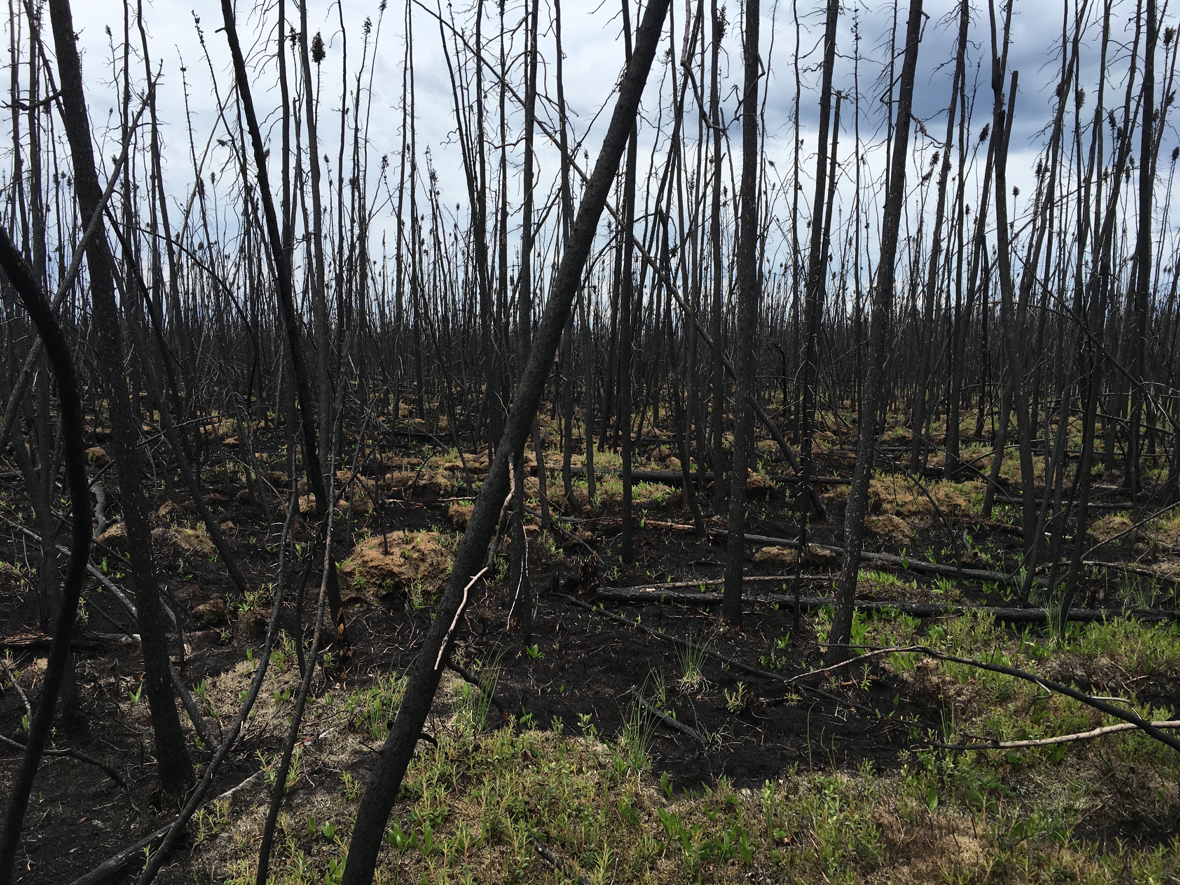
National Aeronautics and Space Administration —
This dataset provides the results of field measurements and estimates of carbon stocks and combustion rates that characterize burned and unburned southern boreal...FederalMISR Level 1B2 Ellipsoid Product subset for the VBBE region V003
National Aeronautics and Space Administration —
VBEMIB2E_003 is the Multi-angle Imaging SpectroRadiometer (MISR) Level 1B2 Ellipsoid Product subset for the VBBE region version 3. It contains Ellipsoid-projected TOA...FederalMISR Level 1B2 Local Mode Terrain Radiance Data V002
National Aeronautics and Space Administration —
MB2LMT_2 is the Multi-angle Imaging SpectroRadiometer (MISR) Level 1B2 Local Mode Terrain Radiance Data Version 2 product. It contains the terrain-projected Top-of-...122 datasets found for "Basic Trading Areas"

Official websites use .gov
A
.gov website belongs to an official government
organization in the United States.
Secure .gov websites use HTTPS
A
lock (
) or https:// means you’ve safely connected to
the .gov website. Share sensitive information only on official,
secure websites.