
-
Federal
CORONA Satellite Photography
National Aeronautics and Space Administration —
On February 24, 1995, President Clinton signed an Executive Order, directing the declassification of intelligence imagery acquired by the first generation of United... -
Federal
National Agriculture Imagery Program (NAIP)
National Aeronautics and Space Administration —
The National Agriculture Imagery Program (NAIP) acquires aerial imagery during the agricultural growing seasons in the continental U.S. A primary goal of the NAIP... -
Federal
CORONA Satellite Photographs from the U.S. Geological Survey
National Aeronautics and Space Administration —
The first generation of U.S. photo intelligence satellites collected more than 860,000 images of the Earth’s surface between 1960 and 1972. The classified military... -
Federal
USGS High Resolution Orthoimagery
National Aeronautics and Space Administration —
High resolution orthorectified images combine the image characteristics of an aerial photograph with the geometric qualities of a map. An orthoimage is a uniform-... -
Federal
LBA-ECO LC-09 Land Cover Transitions Maps for Study Sites in Para, Brazil: 1970-2001
National Aeronautics and Space Administration —
This data set includes classified land cover transition maps at 30-m resolution derived from Landsat TM, MSS, ETM+ imagery and aerial photos of Altamira, Santarem,... -
Federal
National Land Cover Database 2006 (NLCD2006)
National Aeronautics and Space Administration —
National Land Cover Database 2006 (NLCD2006) is a 16-class land cover classification scheme that has been applied consistently across the conterminous United States... -
Federal
Side Looking Airborne Radar (SLAR) Imagery
National Aeronautics and Space Administration —
Side-Looking Airborne Radar (SLAR) imagery is available from the U.S. Geological Survey (USGS) for selected project areas in the conterminous United States and... -
Federal
Aircraft Scanners
National Aeronautics and Space Administration —
The National Aeronautics and Space Administration (NASA) Aircraft Scanners data set contains digital imagery acquired from several multispectral scanners, including... -
Federal
Aerial Photo Single Frames
National Aeronautics and Space Administration —
The Aerial Photography Single Frame Records collection is a large and diverse group of imagery acquired by Federal organizations from 1937 to the present. Over 6.4... -
Federal
USGS Global Fiducials
National Aeronautics and Space Administration —
The Global Fiducials Library (GFL) is a long-term archive of images from U.S. National Imagery Systems which represents a long-term periodic record for selected... -
Federal
Digital SAR Mosaic and Elevation Map of the Greenland Ice Sheet, Version 1
National Aeronautics and Space Administration —
The Digital SAR Mosaic and Elevation Map of the Greenland Ice Sheet combines the most detailed synthetic aperture radar (SAR) image mosaic available with the best... -
Federal
NACP Peatland Land Cover Map of Upper Peninsula, Michigan, 2007-2011
National Aeronautics and Space Administration —
This dataset provides a land cover map focused on peatland ecosystems in the upper peninsula of Michigan. The map was produced at 12.5-m resolution using a multi-... -
Federal
Land Cover and Vegetation Map Collection for Seward Peninsula, Alaska
National Aeronautics and Space Administration —
This data set provides two landcover and vegetation maps for the Seward Peninsula, Alaska. These maps were produced from existing maps, Landsat imagery, and color... -
Federal
High-Resolution Rectified Aerial Photography for Collaborative Research of Environmental Change at Barrow, Alaska, USA, Version 1
National Aeronautics and Space Administration —
This data set includes aerial photography of Barrow, Alaska, which has been geocorrected to a 2002 QuickBird satellite image or Interferometric Synthetic Aperture... -
Federal
ABoVE: Wetland Type, Slave River and Peace-Athabasca Deltas, Canada, 2007 and 2017
National Aeronautics and Space Administration —
This dataset provides ecosystem-types for the Slave River Delta (SRD) and Peace-Athabasca Delta (PAD), Canada, for the time periods circa 2007 and circa 2017. The... -
Federal
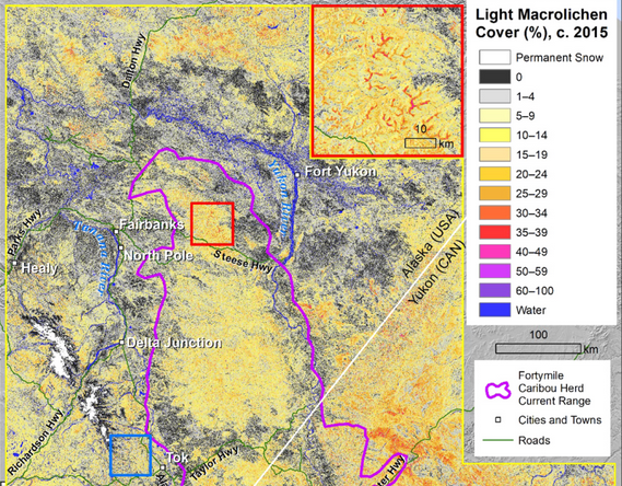
ABoVE: Lichen Forage Cover over Fortymile Caribou Range, Alaska and Yukon, 2000-2015
National Aeronautics and Space Administration —
This dataset provides modeled estimates of lichen ground cover at 30 m resolution across the Fortymile study area in interior eastern Alaska, U.S., and the Yukon... -
Federal
SAFARI 2000 ER-2 Color-IR Aerial Photography, Dry Season 2000
National Aeronautics and Space Administration —
Aerial photography from the NASA ER-2 high altitude aircraft was collected to provide detailed and spatially extensive documentation over parts of the SAFARI study... -
Federal
Multispectral Imagery, NDVI, and Terrain Models, Big Trail Lake, Fairbanks, AK, 2019
National Aeronautics and Space Administration —
This dataset provides multispectral reflectance imagery (green at 550 nm, red at 660 nm, red edge at 735 nm, and near-infrared at 790 nm), normalized difference...

Official websites use .gov
A
.gov website belongs to an official government
organization in the United States.
Secure .gov websites use HTTPS
A
lock (
) or https:// means you’ve safely connected to
the .gov website. Share sensitive information only on official,
secure websites.