
-
Federal
GIBS Web Map Tile Service (WMTS)
National Aeronautics and Space Administration —
The WMTS implementation standard provides a standards-based solution for serviing digital maps using predefined image tiles. Through the constructs of the... -
Federal
Global Hydrologic Soil Groups (HYSOGs250m) for Curve Number-Based Runoff Modeling
National Aeronautics and Space Administration —
This dataset - HYSOGs250m - represents a globally consistent, gridded dataset of hydrologic soil groups (HSGs) with a geographical resolution of 1/480 decimal... -
Federal
Flight Data For Tail 687
National Aeronautics and Space Administration —
The following zip files contain individual flight recorded data in Matlab file format. There are 186 parameters each with a data structure that contains the... -
Federal
Insulated-Gate Bipolar Transistor (IGBT) Accelerated Aging
National Aeronautics and Space Administration —
Preliminary data from thermal overstress accelerated aging using the aging and characterization system. The data set contains aging data from 6 devices, one device... -
Federal
Simulated Fine Particulate Matter (PM2.5) Estimates over Alaska, 2001-2015
National Aeronautics and Space Administration —
The dataset provides simulated PM2.5 concentration estimates over Alaska, U.S. PM2.5 (particulate matter with diameter <= 2.5 microns) concentrations in air... -
Federal
CMS: Forest Biomass and Productivity, 1-degree and 5-km, Conterminous US, 2005
National Aeronautics and Space Administration —
Notice: This data set and guide were updated on June 30, 2014 to correct an error in the reported units. The data values were not changed.Spatially-gridded estimates... -
Federal
Global Vegetation Types, 1971-1982 (Matthews)
National Aeronautics and Space Administration —
The global vegetation type data of 1 x 1 degree latitude and longitude resolution were designed for use in studies of climate and climate change. Vegetation data were... -
Federal
Stream Flow Daily Data: USGS (FIFE)
National Aeronautics and Space Administration —
The Daily Stream Flow Amounts Data Set contains daily measurements of stream flow for the four LTER stations and for the USGS stream-flow station located on... -
Federal
High Resolution Empirical Tide Prediction Software Version 14
National Aeronautics and Space Administration —
This dataset provides sea surface height and ocean surface currents associated with the predictable astronomical tide at the M2, S2, N2, K1, and O1 frequencies. The... -
Federal
Fatigue Crack Growth in Aluminum Lap Joint
National Aeronautics and Space Administration —
Fatigue experiments were conducted on aluminum lap-joint specimens, and lamb wave signals were recorded for each specimen at several time points (i.e., defined as... -
Federal
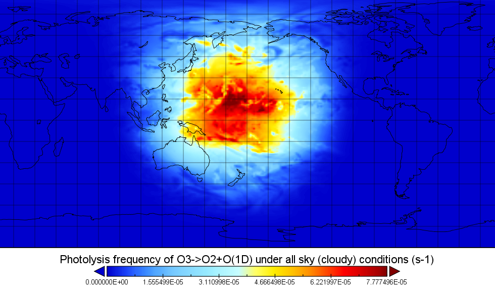
ATom: Global Modeled and CAFS Measured Cloudy and Clear Sky Photolysis Rates, 2016
National Aeronautics and Space Administration —
This dataset provides the results from nine global chemistry-climate or chemistry-transport models that estimated gridded values of atmospheric photolytic rates (J... -
Federal
Regridded Harmonized World Soil Database v1.2
National Aeronautics and Space Administration —
This data set describes select global soil parameters from the Harmonized World Soil Database (HWSD) v1.2, including additional calculated parameters such as area... -
Federal
Global Hyperspectral Imaging Spectral-library of Agricultural crops for Conterminous United States V001
National Aeronautics and Space Administration —
The Global Hyperspectral Imaging Spectral-library of Agricultural crops (GHISA) is a comprehensive compilation, collation, harmonization, and standardization of... -
Federal
Global Soil Profile Data (ISRIC-WISE)
National Aeronautics and Space Administration —
The International Soil Reference and Information Centre-World Inventory of Soil Emission Potentials (ISRIC-WISE) international soil profile data set consists of a... -
Federal
BOREAS HYD-03 Canopy Density Data
National Aeronautics and Space Administration —
The BOREAS HYD-03 team collected several data sets related to the hydrology of forested areas. This data set contains measurements of canopy density (closure) from a... -
Federal
LBA Regional Land Cover from AVHRR, 8-km, 1984 (DeFries et al.)
National Aeronautics and Space Administration —
This data set is a subset of an 8-km global land cover product (DeFries et al. 1998). This subset was created for the study area of the Large Scale Biosphere-... -
Federal
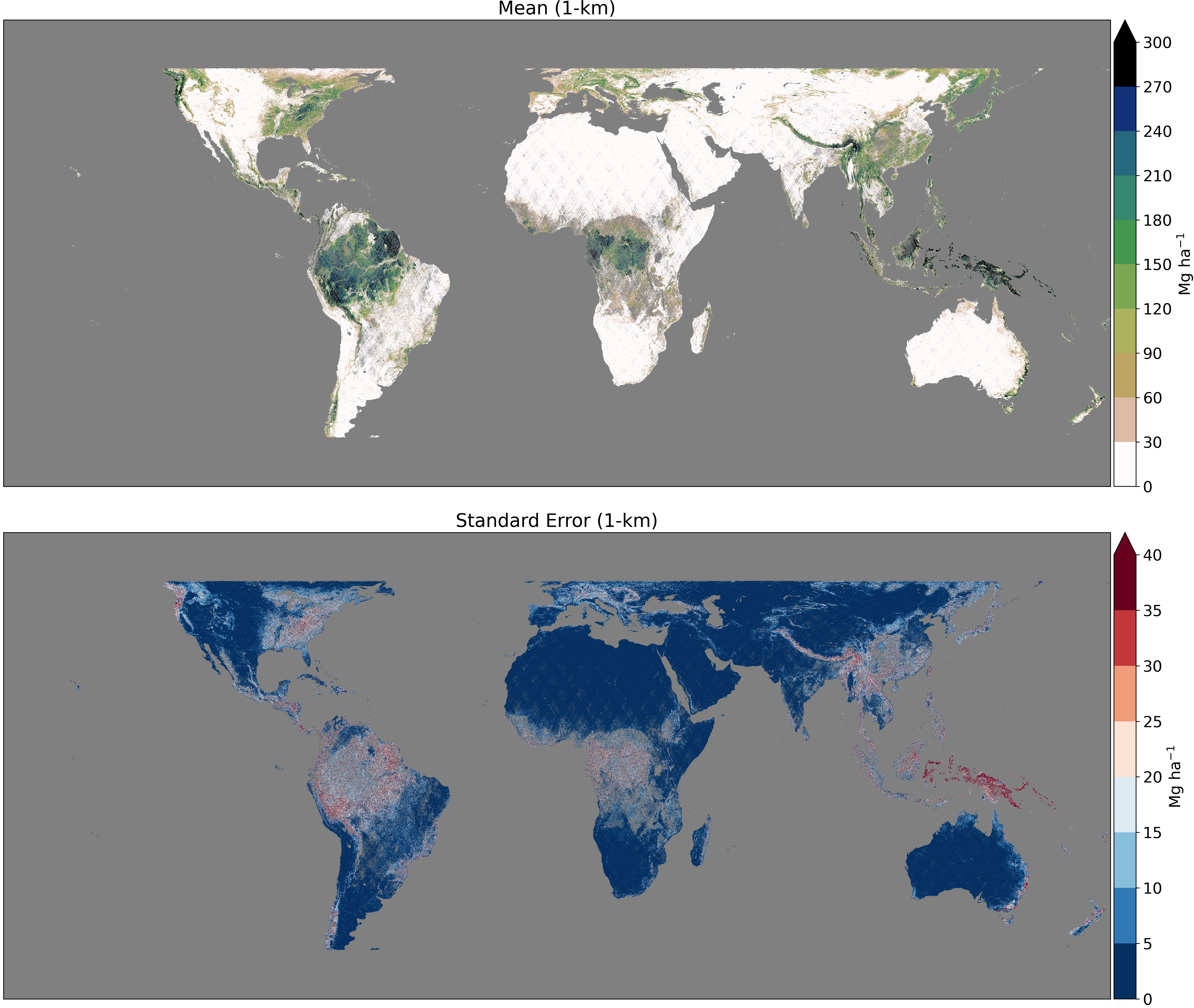
GEDI L4B Gridded Aboveground Biomass Density, Version 2.1
National Aeronautics and Space Administration —
This Global Ecosystem Dynamics Investigation (GEDI) L4B product provides 1 km x 1 km (1 km, hereafter) estimates of mean aboveground biomass density (AGBD) based on... -
Federal
Global 1-km Gridded Thickness of Soil, Regolith, and Sedimentary Deposit Layers
National Aeronautics and Space Administration —
This data set provides high-resolution estimates of the thickness of the permeable layers above bedrock (soil, regolith, and sedimentary deposits) within a global...

Official websites use .gov
A
.gov website belongs to an official government
organization in the United States.
Secure .gov websites use HTTPS
A
lock (
) or https:// means you’ve safely connected to
the .gov website. Share sensitive information only on official,
secure websites.