
-
Federal
GLDAS Noah Land Surface Model L4 monthly 0.25 x 0.25 degree V2.1 (GLDAS_NOAH025_M) at GES DISC recent views
National Aeronautics and Space Administration —
NASA Global Land Data Assimilation System Version 2 (GLDAS-2) has three components: GLDAS-2.0, GLDAS-2.1, and GLDAS-2.2. GLDAS-2.0 is forced entirely with the... -
Federal
ASTER Global Digital Elevation Model V003 NGDA recent views
National Aeronautics and Space Administration —
The ASTER Global Digital Elevation Model (GDEM) Version 3 (ASTGTM) provides a global digital elevation model (DEM) of land areas on Earth at a spatial resolution of 1... -
Federal
GLDAS Catchment Land Surface Model L4 daily 0.25 x 0.25 degree GRACE-DA1 V2.2 (GLDAS_CLSM025_DA1_D) at GES DISC recent views
National Aeronautics and Space Administration —
NASA Global Land Data Assimilation System Version 2 (GLDAS-2) has three components: GLDAS-2.0, GLDAS-2.1, and GLDAS-2.2. GLDAS-2.0 is forced entirely with the... -
Federal
Classification recent views
National Aeronautics and Space Administration —
A supervised learning task involves constructing a mapping from an input data space (normally described by several features) to an output space. A set of training... -
Federal
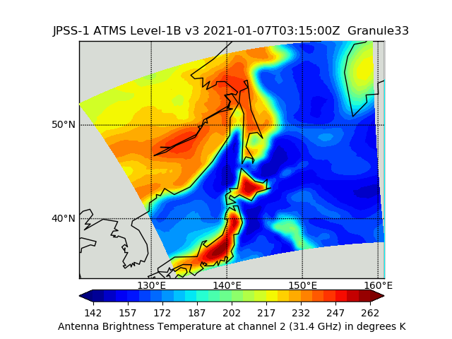
JPSS-1 ATMS Level 1B Brightness Temperature V3 (SNDRJ1ATMSL1B) at GES DISC recent views
National Aeronautics and Space Administration —
The Advanced Technology Microwave Sounder (ATMS) Level 1B data files contain brightness temperature measurements along with ancillary spacecraft, instrument, and... -
Federal
FLDAS Noah Land Surface Model L4 Global Monthly 0.1 x 0.1 degree (MERRA-2 and CHIRPS) V001 (FLDAS_NOAH01_C_GL_M) at GES DISC recent views
National Aeronautics and Space Administration —
This dataset contains a series of land surface parameters simulated from the Noah 3.6.1 model in the Famine Early Warning Systems Network (FEWS NET) Land Data... -
Federal
GLDAS Noah Land Surface Model L4 monthly 1.0 x 1.0 degree V2.1 (GLDAS_NOAH10_M) at GES DISC recent views
National Aeronautics and Space Administration —
NASA Global Land Data Assimilation System Version 2 (GLDAS-2) has three components: GLDAS-2.0, GLDAS-2.1, and GLDAS-2.2. GLDAS-2.0 is forced entirely with the... -
Federal
OSCAR third degree resolution ocean surface currents - yearly files recent views
National Aeronautics and Space Administration —
OSCAR (Ocean Surface Current Analysis Real-time) contains near-surface ocean current estimates, derived using quasi-linear and steady flow momentum equations. The... -
Federal
OMPS-NPP L2 NM Aerosol Index swath orbital recent views
National Aeronautics and Space Administration —
The OMPS-NPP L2 NM Aerosol Index swath orbital product provides aerosol index values from the Ozone Mapping and Profiling Suite (OMPS) Nadir-Mapper (NM) instrument on... -
Federal
BigFoot Field Data for North American Sites, 1999-2003 recent views
National Aeronautics and Space Administration —
The BigFoot project gathered field data for selected EOS Land Validation Sites in North America from 1999 to 2003. Data collected and derived for varying intervals at... -
Federal
Hurricane and Severe Storm Sentinel (HS3) Statistical Hurricane Intensity Prediction Scheme (SHIPS) Intensity V1 recent views
National Aeronautics and Space Administration —
The Hurricane and Severe Storm Sentinel (HS3) Statistical Hurricane Intensity Prediction Scheme (SHIPS) Intensity dataset was obtained from March 18, 2014 through... -
Federal
OMI/Aura Ozone(O3) Total Column 1-Orbit L2 Swath 13x24 km V003 (OMTO3) at GES DISC recent views
National Aeronautics and Space Administration —
The Aura Ozone Monitoring Instrument (OMI) Level-2 Total Column Ozone Data Product OMTO3 (Version 003) is available from the NASA Goddard Earth Sciences Data and... -
Federal
Comparative Analysis of Data-Driven Anomaly Detection Methods recent views
National Aeronautics and Space Administration —
This paper provides a review of three different advanced machine learning algorithms for anomaly detection in continuous data streams from a ground-test firing of a... -
Federal
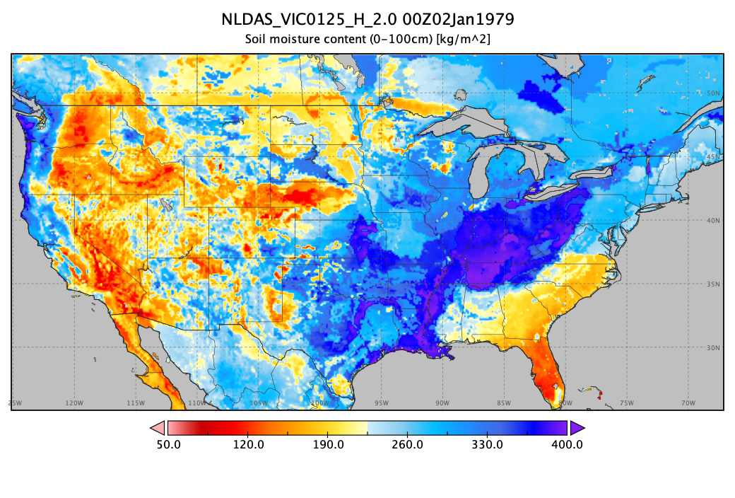
NLDAS VIC Land Surface Model L4 Hourly 0.125 x 0.125 degree V2.0 (NLDAS_VIC0125_H) at GES DISC recent views
National Aeronautics and Space Administration —
This data set contains forty-four fields simulated from the VIC land-surface model (LSM) for Phase 2 of the North American Land Data Assimilation System (NLDAS-2).... -
Federal
Cross-track Infrared Sounder (CrIS) Level 2 Earth System Science Profiling Algorithm Ammonia Retrieval Algorithm (ESSPA-NH3) V1 (SNDRSNIL2ESPNH3) recent views
National Aeronautics and Space Administration —
The objective of this limited edition data collection is to examine the ammonia products generated by the ESSPA (Earth System Science Profiling Algorithm) algorithm... -
Federal
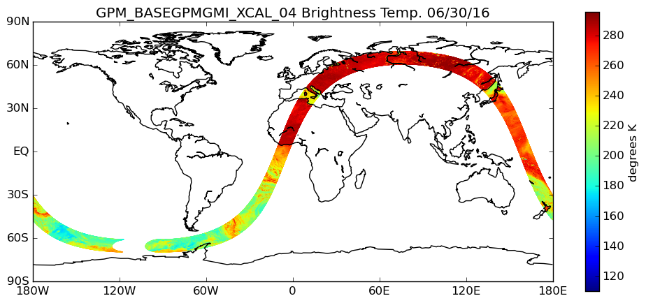
GPM GMI XCAL Common Calibrated Brightness Temperatures L1BASE 1.5 hours 13 km V07 (GPM_BASEGPMGMI_XCAL) at GES DISC recent views
National Aeronautics and Space Administration —
Version 07 is the current version of the data set. Older versions are no longer available and have been superseded by the current version. Consistent rainfall... -
Federal
A Local Asynchronous Distributed Privacy Preserving Feature Selection Algorithm for Large Peer-to-Peer Networks recent views
National Aeronautics and Space Administration —
In this paper we develop a local distributed privacy preserving algorithm for feature selection in a large peer-to-peer environment. Feature selection is often used... -
Federal
GPM SSMIS on F17 (GPROF) Climate-based Radiometer Precipitation Profiling L3 1 day 0.25 degree x 0.25 degree V07 (GPM_3GPROFF17SSMIS_DAY_CLIM) at GES DISC recent views
National Aeronautics and Space Administration —
Version 07 is the current version of the data set. Older versions will no longer be available and have been superseded by Version 07. The "CLIM" products differ from...

Official websites use .gov
A
.gov website belongs to an official government
organization in the United States.
Secure .gov websites use HTTPS
A
lock (
) or https:// means you’ve safely connected to
the .gov website. Share sensitive information only on official,
secure websites.