
-
Federal
NACP Integrated Wildland and Cropland 30-m Fuel Characteristics Map, U.S.A., 2010
National Aeronautics and Space Administration —
The data set provides a 30-m comprehensive fuelbed characteristics map for both the wildland and cropland areas of the conterminous United States (CONUS) for 2010.... -
Federal
LBA-ECO LC-21 Selective Logging Activity in the Brazilian Amazon: 1999-2002
National Aeronautics and Space Administration —
This data set provides the results of analyses of Landsat Enhanced Thematic Mapper Plus (ETM+) images for selective logging activity in the Brazilian states of Para,... -
Federal
NACP North American Forest Dynamics Project: Forest Disturbance and Regrowth Data
National Aeronautics and Space Administration —
This data set provides the results of time-series analyses of Landsat imagery for 55 selected forested sites across the conterminous U.S.A. The output is a pair of... -
Federal
NACP Site: Terrestrial Biosphere Model Output Data in Original Format
National Aeronautics and Space Administration —
This data set contains the original model output data submissions from the 24 terrestrial biosphere models (TBM) that participated in the North American Carbon... -
Federal
A Compilation of Global Soil Microbial Biomass Carbon, Nitrogen, and Phosphorus Data
National Aeronautics and Space Administration —
This data set provides the concentrations of soil microbial biomass carbon (C), nitrogen (N) and phosphorus (P), soil organic carbon, total nitrogen, and total... -
Federal
In-situ Air Temperature and Relative Humidity in Greenbelt, MD, 2013-2015
National Aeronautics and Space Administration —
This data set describes the temperature and relative humidity at 12 locations around Goddard Space Flight Center in Greenbelt MD at 15 minute intervals between... -
Federal
NACP Site: Terrestrial Biosphere Model and Aggregated Flux Data in Standard Format
National Aeronautics and Space Administration —
This data set provides standardized output variables for gross primary productivity (GPP), net ecosystem exchange (NEE), leaf area index (LAI), ecosystem respiration... -
Federal
ABoVE: Wetland Type, Slave River and Peace-Athabasca Deltas, Canada, 2007 and 2017
National Aeronautics and Space Administration —
This dataset provides ecosystem-types for the Slave River Delta (SRD) and Peace-Athabasca Delta (PAD), Canada, for the time periods circa 2007 and circa 2017. The... -
Federal
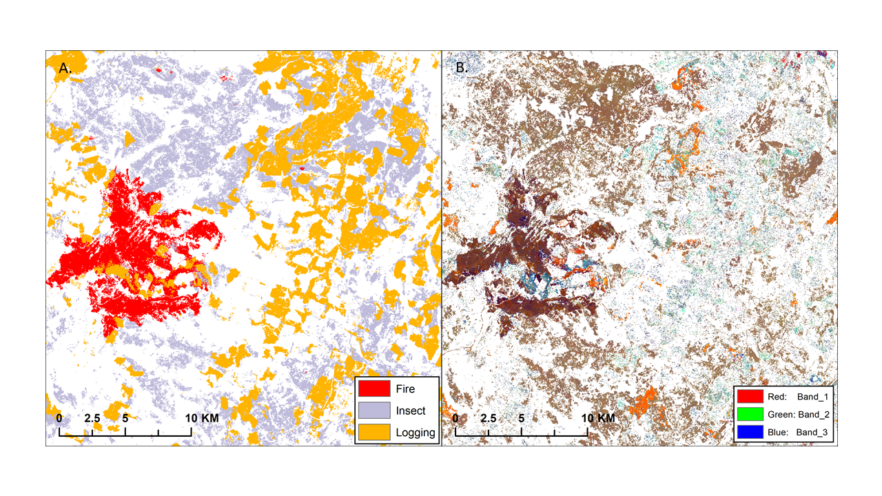
ABoVE: Landsat-derived Annual Disturbance Agents Across ABoVE Core Domain, 1987-2012
National Aeronautics and Space Administration —
This dataset provides spatial data on disturbance agents of fire, insects, and logging in the Arctic Boreal Vulnerability Experiment (ABoVE) core domain at an annual... -
Federal
ABoVE: Burn Severity, Fire Progression, Landcover and Field Data, NWT, Canada, 2014
National Aeronautics and Space Administration —
This data set provides peatland landcover classification maps, fire progression maps, and vegetation community biophysical data collected from areas that were burned... -
Federal
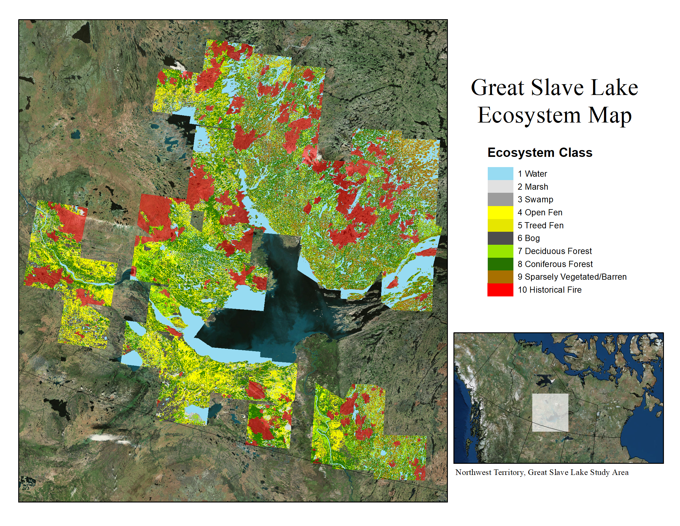
ABoVE: Ecosystem Map, Great Slave Lake Area, Northwest Territories, Canada, 1997-2011
National Aeronautics and Space Administration —
This dataset provides an ecosystem type map at 12.5 meter pixel spacing and 0.2 ha minimum mapping unit for the area surrounding Great Slave Lake, Northwest... -
Federal
Soil Organic Carbon Stock Estimates with Uncertainty across Latin America
National Aeronautics and Space Administration —
This dataset provides 5 x 5 km gridded estimates of soil organic carbon (SOC) across Latin America that were derived from existing point soil characterization data... -
Federal
LBA-ECO LC-07 Validation Overflight for Amazon Mosaics, Video, 1999
National Aeronautics and Space Administration —
This data set presents georeferenced digital video files from Validation Overflight for Amazon Mosaics (VOAM) aerial video surveys as part of the Large-Scale... -
Federal
LBA-ECO CD-10 Tree DBH Measurements at the km 67 Tower Site, Tapajos National Forest
National Aeronautics and Space Administration —
This data sets reports diameter at breast height (DBH) measurements in the old-growth upland forest at the Para Western (Santarem) - km 67, Primary Forest Tower Site.... -
Federal
CMS: LiDAR Data for Forested Areas in Paragominas, Para, Brazil, 2012-2014
National Aeronautics and Space Administration —
This data set provides raw LiDAR point cloud data and derived Digital Terrain Models (DTMs) for five forested areas in the municipality of Paragominas, Para, Brazil,... -
Federal
NACP MCI: CO2 Emissions Inventory, Upper Midwest Region, USA., 2007
National Aeronautics and Space Administration —
This data set provides a bottom-up CO2 emissions inventory for the mid-continent region of the United States for the year 2007. The study was undertaken as part of... -
Federal
BOREAS Agriculture Canada Central Saskatchewan Vector Soils Data, R1
National Aeronautics and Space Administration —
This data set provides soil descriptions for forested areas in the BOREAS southern study area (SSA) in central Saskatchewan, Canada provided by Agriculture Canada.... -
Federal
RLC Forest Fire Images in Russia, 1998-1999
National Aeronautics and Space Administration —
This data set is made up of images of forest fires in Russia from NOAA's Operational Significant Event Imagery (OSEI) archive (http://www.osei.noaa.gov) for the 1998... -
Federal
AfriSAR: Aboveground Biomass for Lope, Mabounie, Mondah, and Rabi Sites, Gabon
National Aeronautics and Space Administration —
This dataset provides gridded estimates of aboveground biomass (AGB) for four sites in Gabon at 0.25 ha (50 m) resolution derived with field measurements and airborne... -
Federal
LBA-ECO LC-14 Biophysical Measurements, Rainfall Exclusion, Tapajos National Forest
National Aeronautics and Space Administration —
This data set reports forest biophysical measurements from a rainfall exclusion experiment conducted at the km 67 Seca Floresta site, Tapajos National Forest, Brazil...

Official websites use .gov
A
.gov website belongs to an official government
organization in the United States.
Secure .gov websites use HTTPS
A
lock (
) or https:// means you’ve safely connected to
the .gov website. Share sensitive information only on official,
secure websites.