
-
Federal
Geostationary Lightning Mapper (GLM) Thunder Hour Data Product
National Aeronautics and Space Administration —
The Geostationary Lightning Mapper (GLM) is the first optical lightning detector in geostationary orbit, and GLM sensors operate aboard the National Oceanic and... -
Federal
NASA Short-term Prediction Research and Transition (SPoRT) Land Information System (LIS)
National Aeronautics and Space Administration —
The Short-term Prediction Research and Transition Land Information System (SPoRT-LIS) is a gridded observations-driven run of the Noah land surface model (LSM) in... -
Federal
GOES-R Geostationary Lightning Mapper (GLM) Gridded Data Products V1
National Aeronautics and Space Administration —
The GOES-R Geostationary Lightning Mapper (GLM) Gridded Data Products consist of full disk extent gridded lightning flash data collected by the Geostationary... -
Federal
GLM Events and Flashes Data
National Aeronautics and Space Administration —
The GLM Events and Flashes Data consist of the size and number of lightning flashes and events. The data were collected from the Geostationary Lightning Mapper (GLM)... -
Federal
ADVANCED MICROWAVE SOUNDING UNIT-A (AMSU-A) SWATH FROM NOAA-16 V1
National Aeronautics and Space Administration —
AMSU-A, the Advanced Microwave Sounding Unit, is a 15-channel passive microwave radiometer used to profile atmospheric temperature and moisture from the earth's... -
Federal
Airborne Precipitation Radar 3rd Generation (APR-3) CPEX V1
National Aeronautics and Space Administration —
The Airborne Precipitation Radar 3rd Generation (APR-3) CPEX dataset consists of radar reflectivity, Doppler velocity for all bands, linear depolarization ratio Ku-... -
Federal
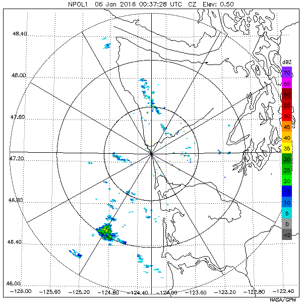
GPM GROUND VALIDATION NASA S-BAND DUAL POLARIMETRIC (NPOL) DOPPLER RADAR IFLOODS
National Aeronautics and Space Administration —
The GPM Ground Validation NASA S-Band Dual Polarimetric (NPOL) Doppler Radar IFloodS dataset was collected from April 30 to June 16, 2013 near Traer, Iowa as part of... -
Federal
GOES-R PLT Southern Ontario Lightning Mapping Array (LMA) V1
National Aeronautics and Space Administration —
The GOES-R PLT Southern Ontario Lightning Mapping Array (LMA) dataset consists of total lightning data measured from the Southern Ontario LMA (SOLMA) network during... -
Federal
GPM Ground Validation Precipitation Estimation from Remotely Sensed Information using Artificial Neural Networks Cloud Classification System (PERSIANN-CCS) IFloodS V1
National Aeronautics and Space Administration —
The GPM Ground Validation Precipitation Estimation from Remotely Sensed Information using Artificial Neural Networks Cloud Classification System (PERSIANN-CCS)... -
Federal
SBU X-band Phased Array Radar (SKYLER) IMPACTS
National Aeronautics and Space Administration —
The SBU X-band Phased Array Radar (SKYLER) IMPACTS dataset consists of polarimetric radar data collected by the Stony Brook University (SBU) X-band Phased Array Radar... -
Federal
CAMEX-3 ER-2 Doppler Radar (EDOP) V1
National Aeronautics and Space Administration —
The CAMEX-3 ER-2 Doppler Radar (EDOP) dataset is a browse-only dataset that consists of plotted reflectivity and Doppler velocity data collected by the ER-2 Doppler... -
Federal
Automated Surface Observing System (ASOS) IMPACTS V1
National Aeronautics and Space Administration —
The Automated Surface Observing Systems (ASOS) IMPACTS dataset consists of a variety of ground-based observations during the Investigation of Microphysics and... -
Federal
GPM Ground Validation NASA EPFL-LTE Parsivel DSD Data Lausanne, Switzerland V1
National Aeronautics and Space Administration —
The GPM Ground Validation NASA EPFL-LTE Parsivel DSD Data Lausanne, Switzerland dataset consists of a network of 16 Parsivel disdrometers deployed on the Ecole... -
Federal
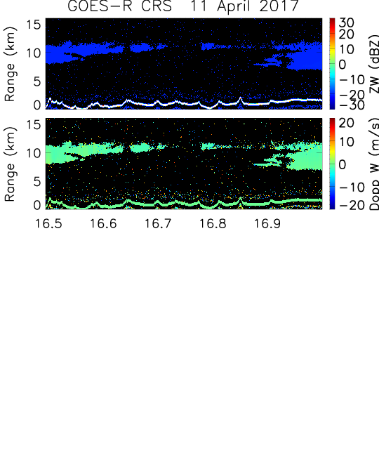
GOES-R PLT Cloud Radar System (CRS) V1
National Aeronautics and Space Administration —
The GOES-R PLT Field Campaign Cloud Radar System (CRS) dataset provides high-resolution profiles of reflectivity and Doppler velocity at aircraft nadir along the... -
Federal
Advanced Vertical Atmospheric Profiling System Dropsondes (AVAPS) IMPACTS V1
National Aeronautics and Space Administration —
The Advanced Vertical Atmospheric Profiling System (AVAPS) IMPACTS dataset consists of vertical atmospheric profile measurements collected by the Advanced Vertical... -
Federal
GOES CPEX V1
National Aeronautics and Space Administration —
The GOES CPEX dataset contains products obtained from the Geostationary Operational Environmental Satellite 13. These data were collected in support of the NASA... -
Federal
GPM Ground Validation NASA S-Band Dual Polarimetric (NPOL) Doppler Radar OLYMPEX V2
National Aeronautics and Space Administration —
The GPM Ground Validation NASA S-Band Dual Polarimetric (NPOL) Doppler Radar OLYMPEX V2 dataset consists of rain rate, reflectivity, Doppler velocity, and other radar...

Official websites use .gov
A
.gov website belongs to an official government
organization in the United States.
Secure .gov websites use HTTPS
A
lock (
) or https:// means you’ve safely connected to
the .gov website. Share sensitive information only on official,
secure websites.