
-
Federal
Weather Research and Forecasting (WRF) Model IMPACTS V1
National Aeronautics and Space Administration —
The Weather Research and Forecasting (WRF) Model IMPACTS dataset includes model data simulated by the Weather Research and Forecasting (WRF) model for the... -
Federal
Geostationary Lightning Mapper (GLM) Thunder Hour Data Product
National Aeronautics and Space Administration —
The Geostationary Lightning Mapper (GLM) is the first optical lightning detector in geostationary orbit, and GLM sensors operate aboard the National Oceanic and... -
Federal
LIS/OTD 2.5 Degree Low Resolution Monthly Climatology Time Series (LRMTS) V2.3.2015
National Aeronautics and Space Administration —
The LIS/OTD 2.5 Degree Low Resolution Monthly Climatology Time Series (LRMTS) contains a variety of gridded climatologies of total lightning flash rates obtained from... -
Federal
World Wide Lightning Location Network (WWLLN) Monthly Thunder Hour Data
National Aeronautics and Space Administration —
The World Wide Lightning Location Network (WWLLN) has monitored global lightning since late 2004. Since 2013, the number of global WWLLN sensors has remained largely... -
Federal
GPM Ground Validation CXSI Radar Imagery OLYMPEX V1
National Aeronautics and Space Administration —
The GPM Ground Validation CXSI Radar Imagery OLYMPEX dataset contains radar reflectivity and precipitation rate images obtained from Environment and Climate Change... -
Federal
ADVANCED MICROWAVE SOUNDING UNIT-A (AMSU-A) SWATH FROM NOAA-16 V1
National Aeronautics and Space Administration —
AMSU-A, the Advanced Microwave Sounding Unit, is a 15-channel passive microwave radiometer used to profile atmospheric temperature and moisture from the earth's... -
Federal
ACES Aircraft and Mechanical Data V1
National Aeronautics and Space Administration —
The ACES Aircraft and Mechanical Data consist of aircraft (e.g. pitch, roll, yaw) and mechanical (e.g. aircraft engine speed, tail commands, fuel levels) data... -
Federal
GOES-R PLT Airborne Visible/Infrared Imaging Spectrometer (AVIRIS) V1
National Aeronautics and Space Administration —
The GOES-R PLT Airborne Visible/Infrared Imaging Spectrometer (AVIRIS) dataset consists of radiance, reflectance, water phase, and navigation data delivered by the... -
Federal
Automated Surface Observing System (ASOS) IMPACTS V1
National Aeronautics and Space Administration —
The Automated Surface Observing Systems (ASOS) IMPACTS dataset consists of a variety of ground-based observations during the Investigation of Microphysics and... -
Federal
Advanced Vertical Atmospheric Profiling System Dropsondes (AVAPS) IMPACTS V1
National Aeronautics and Space Administration —
The Advanced Vertical Atmospheric Profiling System (AVAPS) IMPACTS dataset consists of vertical atmospheric profile measurements collected by the Advanced Vertical... -
Federal
GPM GROUND VALIDATION NASA S-BAND DUAL POLARIMETRIC (NPOL) DOPPLER RADAR IFLOODS
National Aeronautics and Space Administration —
The GPM Ground Validation NASA S-Band Dual Polarimetric (NPOL) Doppler Radar IFloodS dataset was collected from April 30 to June 16, 2013 near Traer, Iowa as part of... -
Federal
GPM GROUND VALIDATION NASA S-BAND DUAL POLARIMETRIC (NPOL) DOPPLER RADAR MC3E V1
National Aeronautics and Space Administration —
The GPM Ground Validation NASA S-band Dual Polarimetric (NPOL) Doppler Radar MC3E dataset was collected by the NASA NPOL radar, which was developed by a research team... -
Federal
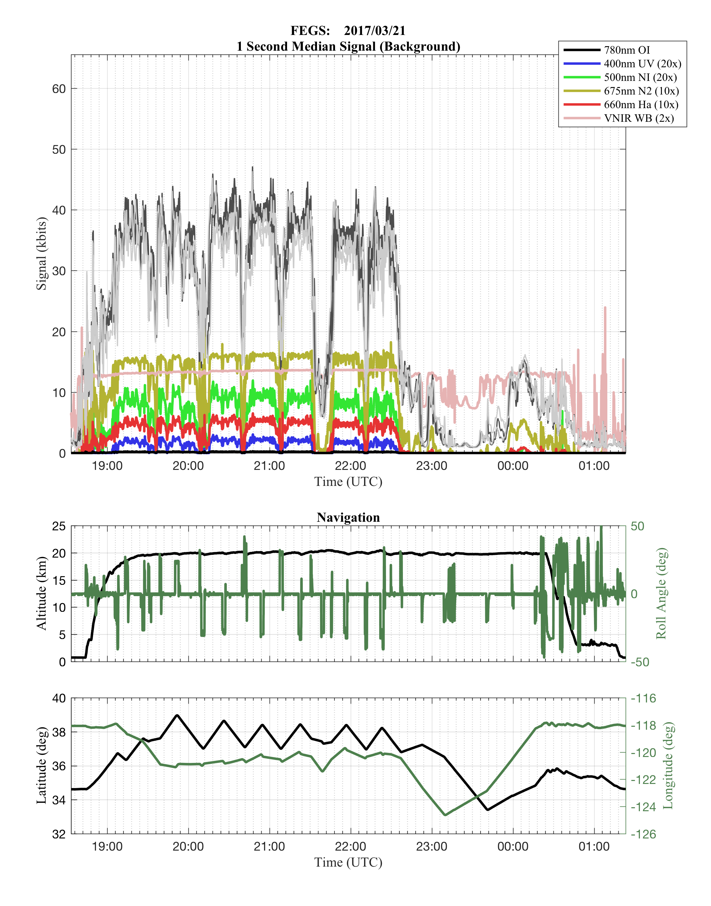
GOES-R PLT Fly's Eye GLM Simulator (FEGS) V1
National Aeronautics and Space Administration —
The GOES-R PLT Fly’s Eye GLM Simulator (FEGS) dataset consists of lightning flash, lightning pulse, and radiance data collected by the FEGS flown aboard a NASA ER-2... -
Federal
GPM GROUND VALIDATION DUAL-FREQUENCY DUAL-POLARIZED DOPPLER RADAR (D3R) GCPEX V1
National Aeronautics and Space Administration —
The GPM Ground Validation Dual-frequency Dual-polarized Doppler Radar (D3R) GCPEx and IFloodS data sets contain radar reflectivity and doppler velocity measurements.... -
Federal
Advanced Microwave Precipitation Radiometer (AMPR) ALOFT
National Aeronautics and Space Administration —
The Advanced Microwave Precipitation Radiometer (AMPR) ALOFT dataset consists of brightness temperature measurements collected by the Advanced Microwave Precipitation... -
Federal
Cloud Radar System (CRS) IMPACTS V1
National Aeronautics and Space Administration —
The Cloud Radar System (CRS) IMPACTS dataset consists of calibrated radar reflectivity, Doppler velocity, linear depolarization ratio, and normalized radar cross-... -
Federal
GOES-R PLT Cloud Physics LiDAR (CPL) V1
National Aeronautics and Space Administration —
The GOES-R PLT Cloud Physics Lidar (CPL) dataset consists of backscatter coefficient, lidar depolarization ratio, layer top/base height, layer type, particulate... -
Federal
New York State Mesonet IMPACTS V1
National Aeronautics and Space Administration —
The New York State Mesonet IMPACTS dataset is a browse-only dataset and consists of temperature, wind, wind direction, mean sea level pressure, precipitation, and...

Official websites use .gov
A
.gov website belongs to an official government
organization in the United States.
Secure .gov websites use HTTPS
A
lock (
) or https:// means you’ve safely connected to
the .gov website. Share sensitive information only on official,
secure websites.