
-
Federal
CMS GOSAT and ObsPack L4 Top-down yearly methane emissions for individual sectors at 0.5x0.625 degrees for North America V1 (CMS_GO_CH4_SEC_TDYC_NA)
National Aeronautics and Space Administration —
Methane emissions are provided by sector in the contiguous United States (CONUS), Canada, and Mexico by inverse analysis of in situ (GLOBALVIEWplus CH4ObsPack) and... -
Federal
GLDAS Catchment Land Surface Model L4 daily 0.25 x 0.25 degree GRACE-DA1 V2.2 (GLDAS_CLSM025_DA1_D_EP) at GES DISC
National Aeronautics and Space Administration —
NASA Global Land Data Assimilation System Version 2 (GLDAS-2) has three components: GLDAS-2.0, GLDAS-2.1, and GLDAS-2.2. GLDAS-2.0 is forced entirely with the... -
Federal
OMI/Aura NO2 Tropospheric, Stratospheric & Total Columns MINDS Daily L2 Global Gridded 0.25 degree x 0.25 degree V1.1 (OMI_MINDS_NO2G) at GES DISC
National Aeronautics and Space Administration —
As part of the NASA's Making Earth System Data Records for Use in Research Environments (MEaSUREs) program, this project entitled “Multi-Decadal Nitrogen Dioxide and... -
Federal
TROPESS Chemical Reanalysis NO 6-Hourly 3-dimensional Product V1 (TRPSCRNO6H3D) at GES DISC
National Aeronautics and Space Administration —
The TROPESS Chemical Reanalysis NO 6-Hourly 3-dimensional Product contains vertical concentrations of nitric oxide. The data are part of the Tropospheric Chemical... -
Federal
MERRA-2 tavg1_2d_flx_Nx: 2d,1-Hourly,Time-Averaged,Single-Level,Assimilation,Surface Flux Diagnostics 0.625 x 0.5 degree V5.12.4 (M2T1NXFLX) at GES DISC
National Aeronautics and Space Administration —
M2T1NXFLX (or tavg1_2d_flx_Nx) is an hourly time-averaged 2-dimensional data collection in Modern-Era Retrospective analysis for Research and Applications version 2... -
Federal
AMSR-MODIS Boundary Layer Water Vapor L3 Monthly 1 degree x 1 degree V1 (AMMBLWV) at GES DISC
National Aeronautics and Space Administration —
This data set provides an estimate the marine boundary layer water vapor beneath uniform cloud fields. Microwave radiometry from AMSR-E and AMSR-2 provides the total... -
Federal
Daily FluxSat GPP of biomass over Land, Based on MODIS Terra and Aqua adjusted reflectance Collection 6.1, on a Global 0.5 by 0.625 Degree Grid, Level 3 Version 2.2
National Aeronautics and Space Administration —
This dataset provides global gridded daily estimates of gross primary production (GPP) and uncertainties at 0.5 deg latitude by 0.625 deg longitude resolution for the... -
Federal
OMI/Aura NO2 Tropospheric, Stratospheric & Total Columns MINDS Daily L3 Global Gridded 0.25 degree x 0.25 degree V1.1 (OMI_MINDS_NO2d) at GES DISC
National Aeronautics and Space Administration —
As part of the NASA's Making Earth System Data Records for Use in Research Environments (MEaSUREs) program, this project entitled “Multi-Decadal Nitrogen Dioxide and... -
Federal
Carbon Monitoring System Lake Superior Primary Production Yearly V1 (CMSLakeSuperiorPPY) at GES DISC
National Aeronautics and Space Administration —
Yearly Average primary production/carbon fixation data for Lake Superior. The primary production data is derived using MODIS imagery with model data.The NASA Carbon... -
Federal
MERRA-2 tavgU_3d_rad_Np: 3d,diurnal,Time-Averaged,Pressure-Level,Assimilation,Radiation Diagnostics 0.625 x 0.5 degree V5.12.4 (M2TUNPRAD) at GES DISC
National Aeronautics and Space Administration —
M2TUNPRAD (or tavgU_3d_rad_Np) is a 3-dimensional monthly diurnal means data collection in Modern-Era Retrospective analysis for Research and Applications version 2... -
Federal
GPM AMSR-E on AQUA Common Calibrated Brightness Temperatures L1C 1.5 hours 10.5 km V07 (GPM_1CAQUAAMSRE) at GES DISC
National Aeronautics and Space Administration —
All 1C products have a common L1C data structure, simple and generic. Each L1C swath includes scan time, latitude and longitude, scan status, quality, incidence... -
Federal
GPM MHS on METOP-B (GPROF) Radiometer Precipitation Profiling L2A 1.5 hours 17 km V07 (GPM_2AGPROFMETOPBMHS) at GES DISC
National Aeronautics and Space Administration —
Version 07 is the current version of the data set. Older versions will no longer be available and have been superseded by Version 07. The 2AGPROF (also known as, GPM... -
Federal
VISSR/SMS-2 Level 1 Atmospheric and Oceanographic Image Processing System (AOIPS) Data V001 (VISSRSMS2L1AOIPS) at GES DISC
National Aeronautics and Space Administration —
VISSRSMS2L1AOIPS is the Visible Infrared Spin-Scan Radiometer (VISSR) Level 1 Atmospheric and Oceanographic Image Processing System (AOIPS) data product from the... -
Federal
TROPESS CrIS-SNPP L2 Ammonia for West Coast Fires, Standard Product V1 (TRPSDL2NH3CRSWCF) at GES DISC
National Aeronautics and Space Administration —
The TROPESS CrIS-SNPP L2 Ammonia for West Coast Fires, Standard Product contains the vertical distribution of the retrieved atmospheric state of ammonia (NH3), formal... -
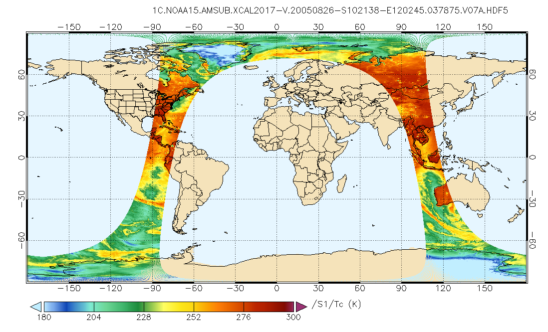
Federal
GPM AMSU-B on NOAA 15 Common Calibrated Brightness Temperatures L1C 1.5 hours 16 km V07 (GPM_1CNOAA15AMSUB) at GES DISC
National Aeronautics and Space Administration —
Version 07 is the current version of the data set. Older versions will no longer be available and have been superseded by Version 07.All 1C products have a common L1C... -
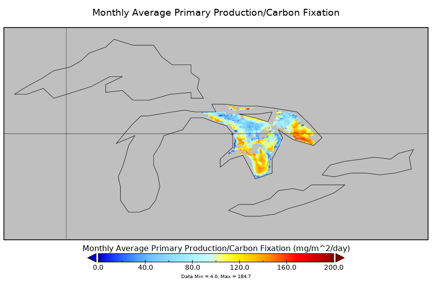
Federal
Carbon Monitoring System Lake Huron Primary Production Monthly V1 (CMSLakeHuronPPM) at GES DISC
National Aeronautics and Space Administration —
Monthly Average primary production/carbon fixation data for Lake Huron. The primary production data is derived using MODIS imagery with model data.The NASA Carbon... -
Federal
NLDAS Noah Land Surface Model L4 Hourly 0.125 x 0.125 degree V2.0 (NLDAS_NOAH0125_H) at GES DISC
National Aeronautics and Space Administration —
This data set contains fifty-three fields simulated from the Noah land-surface model (LSM) for Phase 2 of the North American Land Data Assimilation System (NLDAS-2).... -
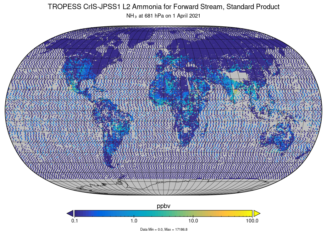
Federal
TROPESS CrIS-JPSS1 L2 Ammonia for Forward Stream, Standard Product V1 (TRPSDL2NH3CRS1FS) at GES DISC
National Aeronautics and Space Administration —
The TROPESS CrIS-JPSS1 L2 Ammonia for Forward Stream, Standard Product contains the vertical distribution of the retrieved atmospheric state of ammonia (NH3), formal... -
Federal
MLS/Aura Level 2 Nitric Acid (HNO3) Mixing Ratio V005 (ML2HNO3) at GES DISC
National Aeronautics and Space Administration —
ML2HNO3 is the EOS Aura Microwave Limb Sounder (MLS) standard product for nitric acid derived from radiances measured by the 240 GHz radiometer at and below 10 hPa,... -
Federal
HAQAST Sentinel-5P TROPOMI Nitrogen Dioxide (NO2) GLOBAL Annual Level 3 0.1 x 0.1 Degree Gridded Data Version 2.4 (HAQ_TROPOMI_NO2_GLOBAL_A_L3) at GES DISC
National Aeronautics and Space Administration —
This product provides level 3 annual averages of tropospheric Nitrogen dioxide (NO2) vertical column density derived from the level 2 Tropospheric Monitoring...

Official websites use .gov
A
.gov website belongs to an official government
organization in the United States.
Secure .gov websites use HTTPS
A
lock (
) or https:// means you’ve safely connected to
the .gov website. Share sensitive information only on official,
secure websites.