
-
Federal
Global Food Security Support Analysis Data (GFSAD) Crop Dominance 2010 Global 1 km V001
National Aeronautics and Space Administration —
The NASA Making Earth System Data Records for Use in Research Environments (MEaSUREs) Global Food Security Support Analysis Data (GFSAD) Crop Dominance Global 1... -
Federal
SENTINEL-1A_OCN
National Aeronautics and Space Administration —
SENTINEL-1A Level 2 Ocean wind, wave and current data -
Federal
Arctic Water Vapor Characteristics from Rawinsondes, Version 1
National Aeronautics and Space Administration —
A gridded climatological monthly-mean data base of Arctic water vapor characteristics has been assembled by combining fixed station data with data from soundings... -
Federal
Sentinel-1 Interferograms - Coherence (BETA)
National Aeronautics and Space Administration —
Sentinel-1 SLC interferometric products generated by JPL using ISCE v2.0.0, delivered by ASF -
Federal
BOREAS RSS-01 PARABOLA SSA Surface Reflectance and Transmittance Data
National Aeronautics and Space Administration —
The BOREAS RSS-01 team collected surface reflectance and transmittance data from three forested sites in the SSA. This data set contains averaged reflectance factors... -
Federal
EMIT L4 Earth System Model Products V001
National Aeronautics and Space Administration —
The Earth Surface Mineral Dust Source Investigation (EMIT) instrument measures surface mineralogy, targeting the Earth’s arid dust source regions. EMIT is installed... -
Federal
SHIFT: Wetland Spectra, Salinity, and Fractional Cover, Devereux Slough, CA, 2022
National Aeronautics and Space Administration —
This dataset includes field data, analysis code, and corresponding airborne imagery collected and generated during the 2022 NASA Surface Biology Geology (SBG) High... -
Federal
Last of the Wild Project, Version 2, 2005 (LWP-2): Global Human Influence Index (HII) Dataset (IGHP)
National Aeronautics and Space Administration —
The Global Human Influence Index Dataset of the Last of the Wild Project, Version 2, 2005 (LWP-2) is a global dataset of 1-kilometer grid cells, created from nine... -
Federal
Last of the Wild Project, Version 1, 2002 (LWP-1): Last of the Wild Dataset (Geographic)
National Aeronautics and Space Administration —
The Last of the Wild Dataset of the Last of the Wild Project, Version 1, 2002 (LWP-1) is derived from the LWP-1 Human Footprint Dataset. The gridded data are... -
Federal
NOAA-20 VIIRS Global Mapped Inherent Optical Properties (IOP) - Near Real-time (NRT) Data, version R2022.0
National Aeronautics and Space Administration —
The Ocean Biology DAAC produces near real-time (quicklook) products using the best-available combination of ancillary data from meteorological and ozone data. As... -
Federal
USGS Global Forest Observations Initiative (GFOI) Colombia
National Aeronautics and Space Administration —
The Global Forest Observations Initiative (GFOI) is an initiative of the inter-governmental Group on Earth Observations (GEO) that aims to: foster the sustained... -
Federal
SENTINEL-1A_SINGLE_POL_GRD_HIGH_RES
National Aeronautics and Space Administration —
Sentinel-1A Single-pol ground projected high and full resolution images -
Federal
CMS: Global 0.5-deg Wetland Methane Emissions and Uncertainty (WetCHARTs v1.3.3)
National Aeronautics and Space Administration —
This dataset provides global monthly wetland methane (CH4) emissions estimates at 0.5 by 0.5-degree resolution for the period 2001-01-01 to 2022-08-31 that were... -
Federal
MODIS/Terra Thermal Anomalies/Fire 5-Min L2 Swath 1km NRT
National Aeronautics and Space Administration —
The MODIS/Terra Thermal Anomalies/Fire 5-Min L2 Swath 1km Near Real Time (NRT), short name MOD14, product is primarily derived from MODIS 4- and 11-micrometer... -
Federal
ECOSTRESS Evaporative Stress Index PT-JPL Daily L4 Global 70m V001
National Aeronautics and Space Administration —
The ECOsystem Spaceborne Thermal Radiometer Experiment on Space Station (ECOSTRESS) mission measures the temperature of plants to better understand how much water... -
Federal
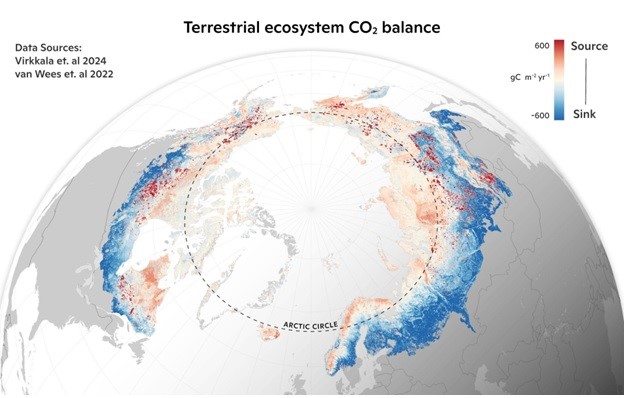
Machine learning-based Arctic-boreal terrestrial ecosystem CO2 fluxes, 2001-2020
National Aeronautics and Space Administration —
This dataset provides gridded estimates of gross primary productivity (GPP), ecosystem respiration (Reco), and net ecosystem CO2 exchange (NEE) across the circumpolar... -
Federal
Global Food Security-support Analysis Data (GFSAD) Cropland Extent-Product 2015 Validation 30 m V001
National Aeronautics and Space Administration —
The NASA Making Earth System Data Records for Use in Research Environments (MEaSUREs) Global Food Security-support Analysis Data (GFSAD) data product provides...

Official websites use .gov
A
.gov website belongs to an official government
organization in the United States.
Secure .gov websites use HTTPS
A
lock (
) or https:// means you’ve safely connected to
the .gov website. Share sensitive information only on official,
secure websites.