
-
Federal
MASTER: Geological Earth Mapping Experiment (GEMx), Spring 2024
National Aeronautics and Space Administration —
This dataset includes Level 1B (L1B) data products from the MODIS/ASTER Airborne Simulator (MASTER) instrument. The spectral data were collected during 26 flights... -
Federal
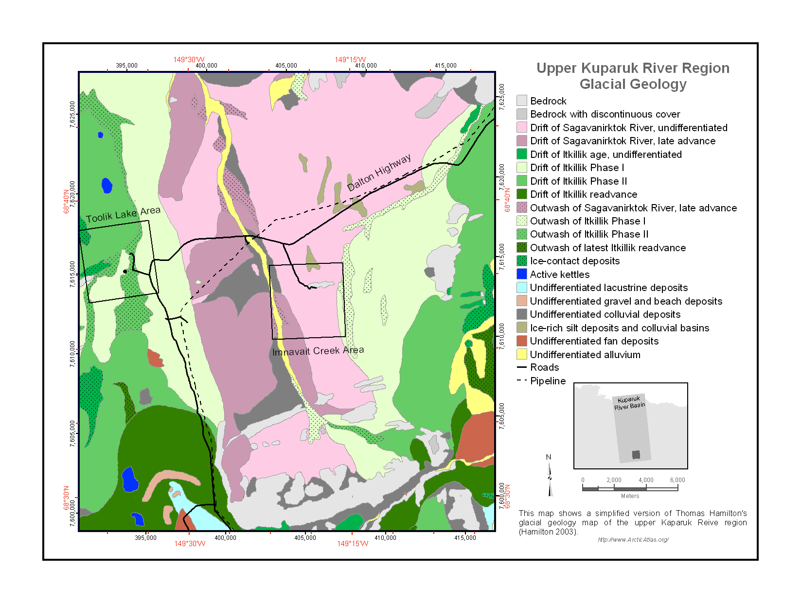
Maps of Vegetation Types and Physiographic Features, Kuparuk River Basin, Alaska
National Aeronautics and Space Administration —
This data set provides a collection of vegetation, landscape, geobotanical, elevation, hydrology, and geologic maps for the Kuparuk River Basin, North Slope, Alaska.... -
Federal
Heat Capacity Mapping Mission (HCMM)
National Aeronautics and Space Administration —
The mission was the first of a series of NASA Applications Explorer Missions and is also known as AEM-A. Day/night coverage over a given area occurred at intervals... -
Federal
MESSENGER Magnetometer (MAG) Interplanetary Magnetic Field, Radial-Tangential-Normal, RTN, Coordinates, High Resolution, 1 s Data
National Aeronautics and Space Administration —
This MESSENGER Magnetic field data set contains cruise-phase magnetic field vectors in RTN coordinates at time resolutions typically of 0.5 s or 1.0 s and sometimes... -
Federal
Permafrost Map of Alaska, USA, Version 1
National Aeronautics and Space Administration —
This data set consists of a geo-referenced digital map and attribute data derived from the publication 'Permafrost map of Alaska'. The map is presented at a scale of... -
Federal
VO1/VO2 MARS INFRARED THERMAL MAPPER RESAMPLED DATA V1.0
National Aeronautics and Space Administration —
This data set contains the Infrared Thermal Mapping (IRTM) data of Mars acquired by the Viking orbiters. The database contains the time, geometry, and radiative... -
Federal
NLCD 1992/2001 Retrofit Land Cover Change Product
National Aeronautics and Space Administration —
Developments in mapping methodology, new sources of input data, and changes in the mapping legend for the 2001 National Land Cover Database (NLCD2001) will confound... -
Federal
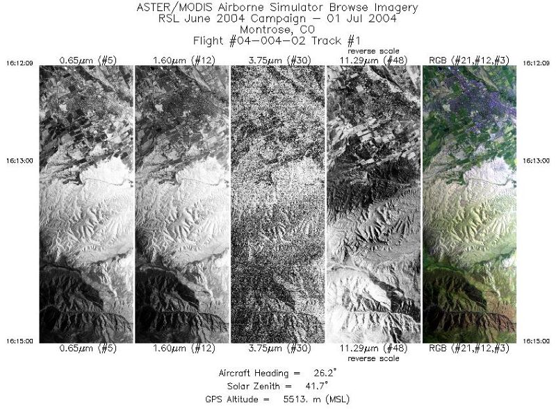
MASTER: Geological substrate mapping, Utah-Colorado, June, 2004
National Aeronautics and Space Administration —
This dataset includes Level 1B (L1B) data products from the MODIS/ASTER Airborne Simulator (MASTER) instrument. The spectral data were collected during two flights... -
Federal
SWOT Level 2 Radiometer Brightness Temperatures and Troposphere Operational Data Product Version D
National Aeronautics and Space Administration —
The SWOT Level 2 Radiometer Brightness Temperatures and Troposphere Operational Geophysical Data Record (OGDR) Version D dataset produced by the Surface Water and... -
Federal
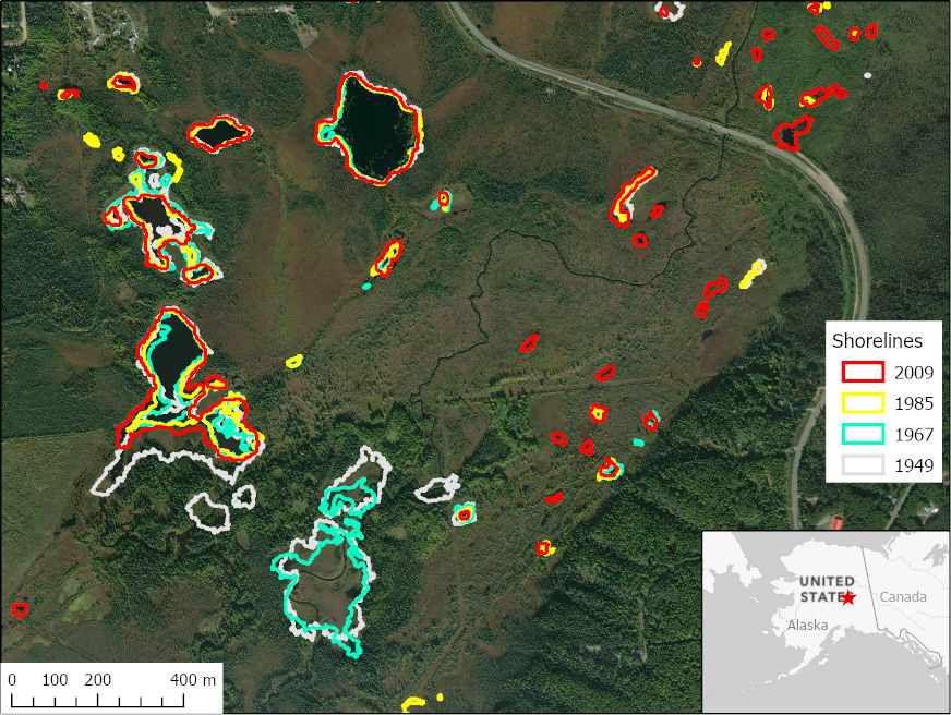
ABoVE: Historical Lake Shorelines and Areas near Fairbanks, Alaska from 1949-2009
National Aeronautics and Space Administration —
This dataset includes maps of historical lake shorelines with derived lake areas in the southern portion of the Goldstream Valley and the surrounding landscape north... -
Federal
SWOT Level 2 Radiometer Brightness Temperatures and Troposphere Interim Data Product
National Aeronautics and Space Administration —
The SWOT Level 2 Radiometer Brightness Temperatures and Troposphere Interim Geophysical Data Record (IGDR) Version 1.0 dataset produced by the Surface Water and Ocean... -
Federal
AVIRIS-NG L1B Calibrated Radiance, Facility Instrument Collection, V1
National Aeronautics and Space Administration —
This dataset contains Level 1B (L1B) orthocorrected, scaled radiance image files as well as files of observational geometry and illumination parameters and supporting... -
Federal
SWOT Level 2 Radiometer Brightness Temperatures and Troposphere Interim Data Product, Version 2.0
National Aeronautics and Space Administration —
The SWOT Level 2 Radiometer Brightness Temperatures and Troposphere Interim Geophysical Data Record (IGDR) Version 1.0 dataset produced by the Surface Water and Ocean... -
Federal
MOLA MISSION EXPERIMENT GRIDDED DATA RECORD
National Aeronautics and Space Administration —
The Mars Global Surveyor spacecraft includes a laser altimeter instrument. The primary objective of the Mars Orbiter Laser Altimeter (MOLA) is to determine globally... -
Federal
HDDS_Baseline_Adhoc
National Aeronautics and Space Administration —
The U.S. Geological Survey (USGS) Emergency Operations, in support of the Department of Homeland Security, provides imagery and resources for use in disaster... -
Federal
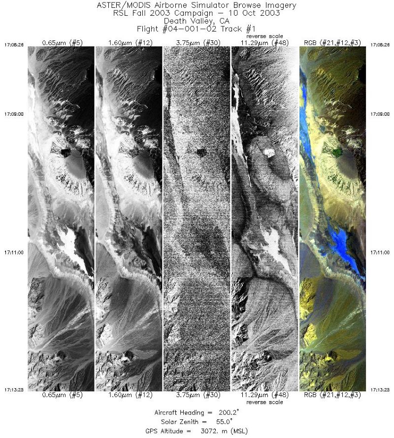
MASTER: Geological fault mapping, California-Nevada, October, 2003
National Aeronautics and Space Administration —
This dataset includes Level 1B (L1B) data products from the MODIS/ASTER Airborne Simulator (MASTER) instrument. The spectral data were collected during six flights... -
Federal
Rock glaciers, Entremont, Valais, Switzerland, Version 1
National Aeronautics and Space Administration —
The Entremont area is 300 square km wide and located in the western part of the Swiss Alps between the Mont-Blanc Massif and the Valaisian Alps, slightly north of the... -
Federal
SHIFT: AVIRIS-NG L2A Unrectified Surface Reflectance Version 1
National Aeronautics and Space Administration —
This dataset contains Level 2A (L2A) unrectified surface reflectance images from NASA's Airborne Visible / Infrared Imaging Spectrometer-Next Generation (AVIRIS-NG)... -
Federal
Borehole temperatures in deep wells of Western Siberia, Russia, 1960-1995, Version 1
National Aeronautics and Space Administration —
This data set is a database of the permafrost and geothermal conditions of the oil and gas deposits of Western Siberia. Data were taken from 736 plots, each having...

Official websites use .gov
A
.gov website belongs to an official government
organization in the United States.
Secure .gov websites use HTTPS
A
lock (
) or https:// means you’ve safely connected to
the .gov website. Share sensitive information only on official,
secure websites.