
-
Federal
USGS Digital Orthophoto Quadrangles
National Aeronautics and Space Administration —
A Digital Orthophoto Quadrangle (DOQ) is a computer-generated image of an aerial photograph in which the image displacement caused by terrain relief and camera tilt... -
Federal
Sentinel-5P TROPOMI Total Ozone Column 1-Orbit L2 7km x 3.5km V1 (S5P_L2__O3_TOT) at GES DISC
National Aeronautics and Space Administration —
Starting from August 6th in 2019, Sentinel-5P TROPOMI along-track high spatial resolution (~5.5km at nadir) has been implemented. Starting from July 13th in 2020,... -
Federal
GEDI L2A Elevation and Height Metrics Data Global Footprint Level V002
National Aeronautics and Space Administration —
The Global Ecosystem Dynamics Investigation (GEDI) mission aims to characterize ecosystem structure and dynamics to enable radically improved quantification and... -
Federal
Inductive Monitoring System (IMS)
National Aeronautics and Space Administration —
IMS: Inductive Monitoring System The Inductive Monitoring System (IMS) is a tool that uses a data mining technique called clustering to extract models of normal... -
Federal
MASH Catalogs of MASH Planetary Nebulae
National Aeronautics and Space Administration —
The first part of the Macquarie/AAO/Strasbourg H-alpha Planetary Nebula Catalog (MASH) contains 903 new true, likely and possible Galactic planetary nebulae (PNe)... -
Federal
The Fourth U.S. Naval Observatory CCD Astrograph Catalog
National Aeronautics and Space Administration —
UCAC4 is a compiled, all-sky star catalog covering mainly the 8 to 16 magnitude range in a single bandpass between V and R. Positional errors are about 15 to 20 mas... -
Federal
GEOS-Carb CASA-GFED Daily Fire and Fuel Emissions 0.5 degree x 0.5 degree V3 (GEOS_CASAGFED_D_FIRE) at GES DISC
National Aeronautics and Space Administration —
This product provides Daily average wildfire emissions (FIRE) andfuel wood burning emissions (FUEL) derived from the Carnegie-Ames-Stanford-Approach – Global Fire... -
Federal
ORACLES Trace Gas Aircraft InSitu Data
National Aeronautics and Space Administration —
ORACLES_TraceGas_AircraftInSitu_Data are in situ trace gas measurements collected onboard the P-3 Orion or ER-2 aircraft during the ObseRvations of Aerosols above... -
Federal
ASTEROID NAMES AND DISCOVERY V7.0
National Aeronautics and Space Administration —
This data set lists name, designation(s), and discovery circumstances for all asteroids numbered as of the given stop date. It is compiled and maintain by David... -
Federal
LAT 2-year Point Source Catalog
National Aeronautics and Space Administration —
The Fermi Gamma-ray Space Telescope (Fermi) Large Area Telescope (LAT) is a successor to EGRET, with greatly improved sensitivity, resolution, and energy range. This... -
Federal
GPM IMERG Early Precipitation L3 1 day 0.1 degree x 0.1 degree V07 (GPM_3IMERGDE) at GES DISC
National Aeronautics and Space Administration —
Version 07 is the current version of the data set. Older versions will no longer be available and have been superseded by Version 07.The Integrated Multi-satellitE... -
Federal
Suomi-NPP VIIRS Global Binned Inherent Optical Properties (IOP) - Near Real-time (NRT) Data, version R2022.0
National Aeronautics and Space Administration —
The Ocean Biology DAAC produces near real-time (quicklook) products using the best-available combination of ancillary data from meteorological and ozone data. As... -
Federal
GPM SSMIS on F16 (GPROF) Radiometer Precipitation Profiling L2 1.5 hours 12 km V07 (GPM_2AGPROFF16SSMIS) at GES DISC
National Aeronautics and Space Administration —
Version 07 is the current version of the data set. Older versions will no longer be available and have been superseded by Version 07.The 2AGPROF (Goddard Profiling)... -
Federal
MODIS/Aqua+Terra Global Flood Product L3 NRT 250m 2-day GeoTIFF
National Aeronautics and Space Administration —
The MODIS/Aqua+Terra Global Flood Product L3 Near Real Time (NRT) 250m 2-day GeoTIFF Product (MCDWD_L3_F2_NRT) (beta) provides maps of flooding globally. The Global... -
Federal
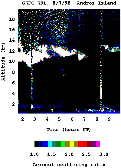
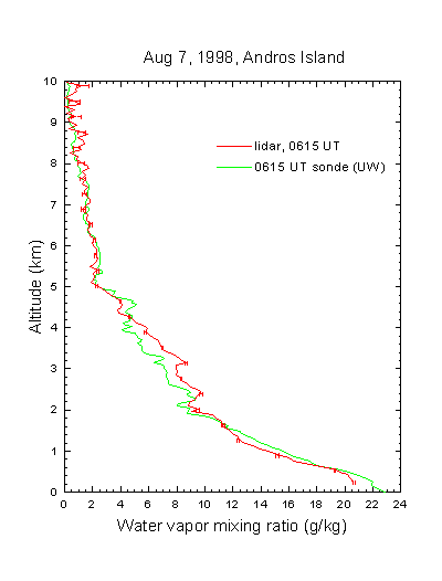
CAMEX-3 SCANNING RAMAN LIDAR V1
National Aeronautics and Space Administration —
The CAMEX-3 Scanning Raman LIDAR dataset collected data during the CAMEX-3 campaign on Andros Island during the period 6 August - 20 September 1998. The SRL... -
Federal
First ISCCP Regional Experiment (FIRE) Cirrus Phase II National Weather Service(NWS) Inner-Network Rawinsonde Data
National Aeronautics and Space Administration —
The First ISCCP Regional Experiments have been designed to improve data products and cloud/radiation parameterizations used in general circulation models (GCMs).... -
Federal
SnowEx23 Oct22 Laser Snow Microstructure Specific Surface Area Low-snow V001
National Aeronautics and Space Administration —
This data set reports vertical profiles of snow reflectance and specific surface area (SSA) collected in October 2022 as part of the NASA SnowEx 2023 Alaska field... -
Federal
Gene expression profiling in human fibroblast after low-LET irradiation
National Aeronautics and Space Administration —
Exposure to radiation provokes cellular responses controlled in part by gene expression networks. MicroRNAs (miRNAs) are small non-coding RNAs which mostly regulate... -
Federal
NRAO VLA Sky Survey Catalog
National Aeronautics and Space Administration —
This table contains the National Radio Astronomy Observatory (NRAO) Very Large Array (VLA) Sky Survey, the so-called NVSS Catalog. The NVSS Catalog covers the sky... -
Federal
IMS HIGH INTENSITY SPECTROMETER V1.0
National Aeronautics and Space Administration —
This data set lists counts as a function of either angular position or energy level. The data were obtained from the Ion Mass Spectrometer (IMS) High Intensity...

Official websites use .gov
A
.gov website belongs to an official government
organization in the United States.
Secure .gov websites use HTTPS
A
lock (
) or https:// means you’ve safely connected to
the .gov website. Share sensitive information only on official,
secure websites.