
-
Federal
Ecosystem Demography Model: Scaling Vegetation Dynamics Across South America
National Aeronautics and Space Administration —
This model product contains the source code for the Ecosystem Demography Model (ED version 1.0) as well as model input and output data for a portion of South America... -
Federal
BOREAS Site and Area Geographic Coordinate Information
National Aeronautics and Space Administration —
In an effort to properly document the sites and areas where data were collected, personnel of the BOReal Ecosystem-Atmosphere Study (BOREAS) Information System... -
Federal
BOREAS TE-18 Geosail Canopy Reflectance Model
National Aeronautics and Space Administration —
The SAIL (Scattering from Arbitrarily Inclined Leaves) model was combined with the Jasinski geometric model to simulate canopy spectral reflectance and absorption of... -
Federal
Tidal Wetland Soil Carbon Stocks for the Conterminous United States, 2006-2010
National Aeronautics and Space Administration —
This dataset provides modeled estimates of soil carbon stocks for tidal wetland areas of the Conterminous United States (CONUS) for the period 2006-2010. Wetland... -
Federal
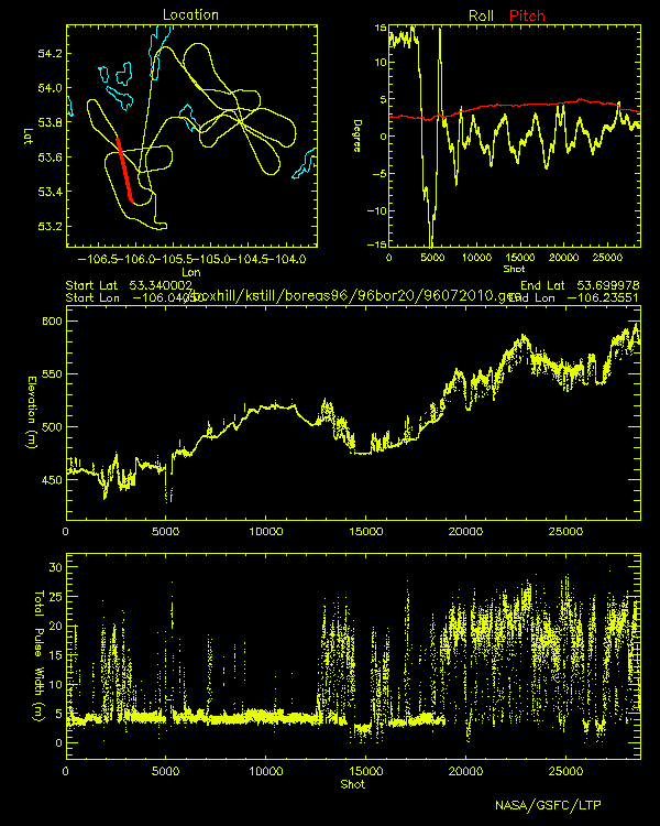
BOREAS Scanning Lidar Imager of Canopies by Echo Recovery (SLICER): Level-3 Data
National Aeronautics and Space Administration —
Scanning Lidar Imager of Canopies by Echo Recovery (SLICER) data were acquired in support of BOReal Ecosystem-Atmosphere Study (BOREAS) at all of the Tower Flux (TF)... -
Federal
BOREAS TE-19 Ecosystem Carbon Balance Model
National Aeronautics and Space Administration —
The BOREAS TE-19 team developed a model called the Spruce and Moss Model (SPAM) designed to simulate the daily carbon balance of a black spruce/moss boreal forest... -
Federal
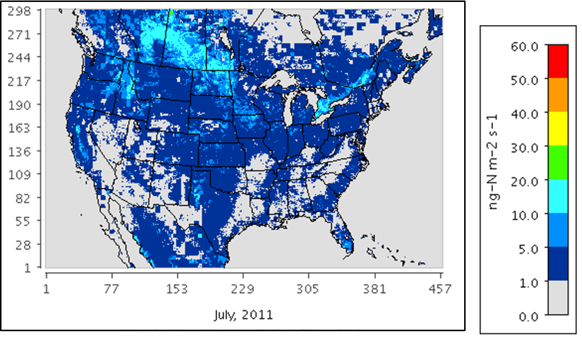
Mechanistic Module for Soil Nitrogen Emissions for CMAQ Model, North America, 2011
National Aeronautics and Space Administration —
This model product provides source code, input data files, and example model outputs for a new mechanistic soil nitrogen (N) module in-line with the Community... -
Federal
BDSNP Module for Improved Soil NO Emission Estimates for CMAQ Model, Conterminous USA
National Aeronautics and Space Administration —
This model product provides: (1) the source code for the updated Berkeley-Dalhousie Soil Nitric Oxide (NO) Parameterization module (BDSNP, Version 1.0) as implemented... -
Federal
Global Food Security-support Analysis Data (GFSAD) Cropland Extent 2015 Southeast and Northeast Asia product 30 m V001
National Aeronautics and Space Administration —
The NASA Making Earth System Data Records for Use in Research Environments (MEaSUREs) Global Food Security-support Analysis Data (GFSAD) data product provides... -
Federal
Land Surface Model (LSM 1.0) for Ecological, Hydrological, Atmospheric Studies
National Aeronautics and Space Administration —
The NCAR LSM 1.0 is a land surface model developed by Gordon Bonan to examine biogeophysical and biogeochemical land-atmosphere interactions, especially the effects... -
Federal
BOREAS Elevation Contours over the NSA and SSA ARC/Info Generate Format
National Aeronautics and Space Administration —
This data set was prepared by BORIS staff by reformatting the original data into the ARC/INFO Generate format. The original data were received in SIF at a scale of... -
Federal
Global Food Security-support Analysis Data (GFSAD) Cropland Extent 2015 Europe, Central Asia, Russia, Middle East product 30 m V001
National Aeronautics and Space Administration —
The NASA Making Earth System Data Records for Use in Research Environments (MEaSUREs) Global Food Security-support Analysis Data (GFSAD) data product provides... -
Federal
AERONET-OCEAN COLOR
National Aeronautics and Space Administration —
The Aerosol Robotic Network (AERONET), developed to sustain atmospheric studies at various scales with measurements from worldwide distributed autonomous sun-... -
Federal
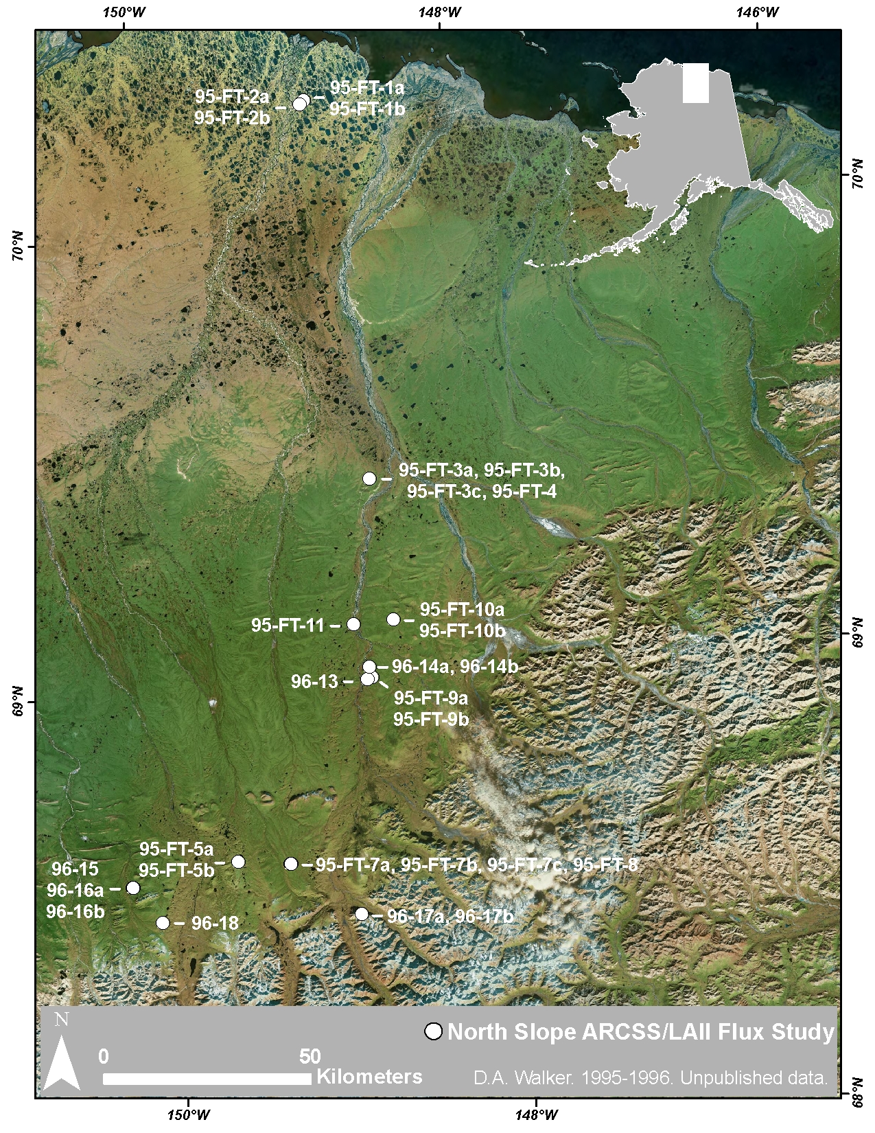
Arctic Vegetation Plots at ARCSS/LAII Flux Sites, North Slope, Alaska, 1995-1996
National Aeronautics and Space Administration —
This dataset provides vegetation cover and environmental plot and soil data collected at flux tower sites of the North Slope Arctic System Science/Land-Atmosphere-Ice... -
Federal
Global Soil Texture and Derived Water-Holding Capacities (Webb et al.)
National Aeronautics and Space Administration —
A standardized global data set of soil horizon thicknesses and textures (particle size distributions) was compiled by Webb et al. This data set will be used for the... -
Federal
ARC Code TI: EOS Clearinghouse (ECHO)
National Aeronautics and Space Administration —
ECHO is a clearinghouse of Earth science Metadata under the EOS Program. -
Federal
Wetland Salinity Maps of Select Estuary Sites in the United States, 2020
National Aeronautics and Space Administration —
This dataset provides gridded average annual wetland salinity concentrations in practical salinity units (PSU) at 30-meter resolution within 24 coastal estuary sites... -
Federal
Global Food Security-support Analysis Data (GFSAD) Cropland Extent-Product 2015 Validation 30 m V001
National Aeronautics and Space Administration —
The NASA Making Earth System Data Records for Use in Research Environments (MEaSUREs) Global Food Security-support Analysis Data (GFSAD) data product provides... -
Federal
Global Food Security-support Analysis Data (GFSAD) Cropland Extent 2015 South America product 30 m V001
National Aeronautics and Space Administration —
The NASA Making Earth System Data Records for Use in Research Environments (MEaSUREs) Global Food Security-support Analysis Data (GFSAD) data product provides... -
Federal
Cloud Regime for CRE Feedback Study
National Aeronautics and Space Administration —
Cloud-only regimes (and 3 sub-regimes of CR15) originally derived from Terra and Aqua observations in 50S-50N, and corresponding "regime numbers on map" files...

Official websites use .gov
A
.gov website belongs to an official government
organization in the United States.
Secure .gov websites use HTTPS
A
lock (
) or https:// means you’ve safely connected to
the .gov website. Share sensitive information only on official,
secure websites.