
-
Federal
Mercury Map Catalog
National Aeronautics and Space Administration —
The Mercury Map Catalog includes various mappings of the surface of Mercury published by the U.S. Geological Survey from 1976 - 1990. -
Federal
Landsat 7 Data Sets
National Aeronautics and Space Administration —
Landsat represents the world's longest continuously acquired collection of space-based moderate-resolution land remote sensing data. Four decades of imagery provides... -
Federal
LBA Regional River Discharge Data (Coe and Olejniczak)
National Aeronautics and Space Administration —
This data set is a subset of a global river discharge data set by Coe and Olejniczak (1999). The subset was created for the study area of the Large Scale Biosphere-... -
Federal
ARCB/GSSR M RADIO TELESC DERIVED RADAR MODEL UNIT MAP V1.0
National Aeronautics and Space Administration —
A model for Mars depolarized radar echo power that (1) matches the observed variation of total radar cross section with longitude and (2) produces model spectra that... -
Federal
MEaSUREs Greenland Ice Velocity: Selected Glacier Site Single-Pair Velocity Maps from Optical Images V001
National Aeronautics and Space Administration —
This data set, part of the NASA Making Earth System Data Records for Use in Research Environments (MEaSUREs) program, consists of surface velocity estimates for... -
Federal
SWOT Level 2 Radiometer Brightness Temperatures and Troposphere Operational Data Product, Version 2.0
National Aeronautics and Space Administration —
The SWOT Level 2 Radiometer Brightness Temperatures and Troposphere Operational Geophysical Data Record (OGDR) Version 1.0 dataset produced by the Surface Water and... -
Federal
National Land Cover Data set 1992 (NLCD1992)
National Aeronautics and Space Administration —
National Land Cover Dataset 1992 (NLCD1992) is a 21-class land cover classification scheme that has been applied consistently across the lower 48 United States at a... -
Federal
North American Landscape Characterization
National Aeronautics and Space Administration —
The North American Landscape Characterization (NALC) project is a component of the Landsat Pathfinder Program, which is part of a larger Pathfinder Program initiated... -
Federal
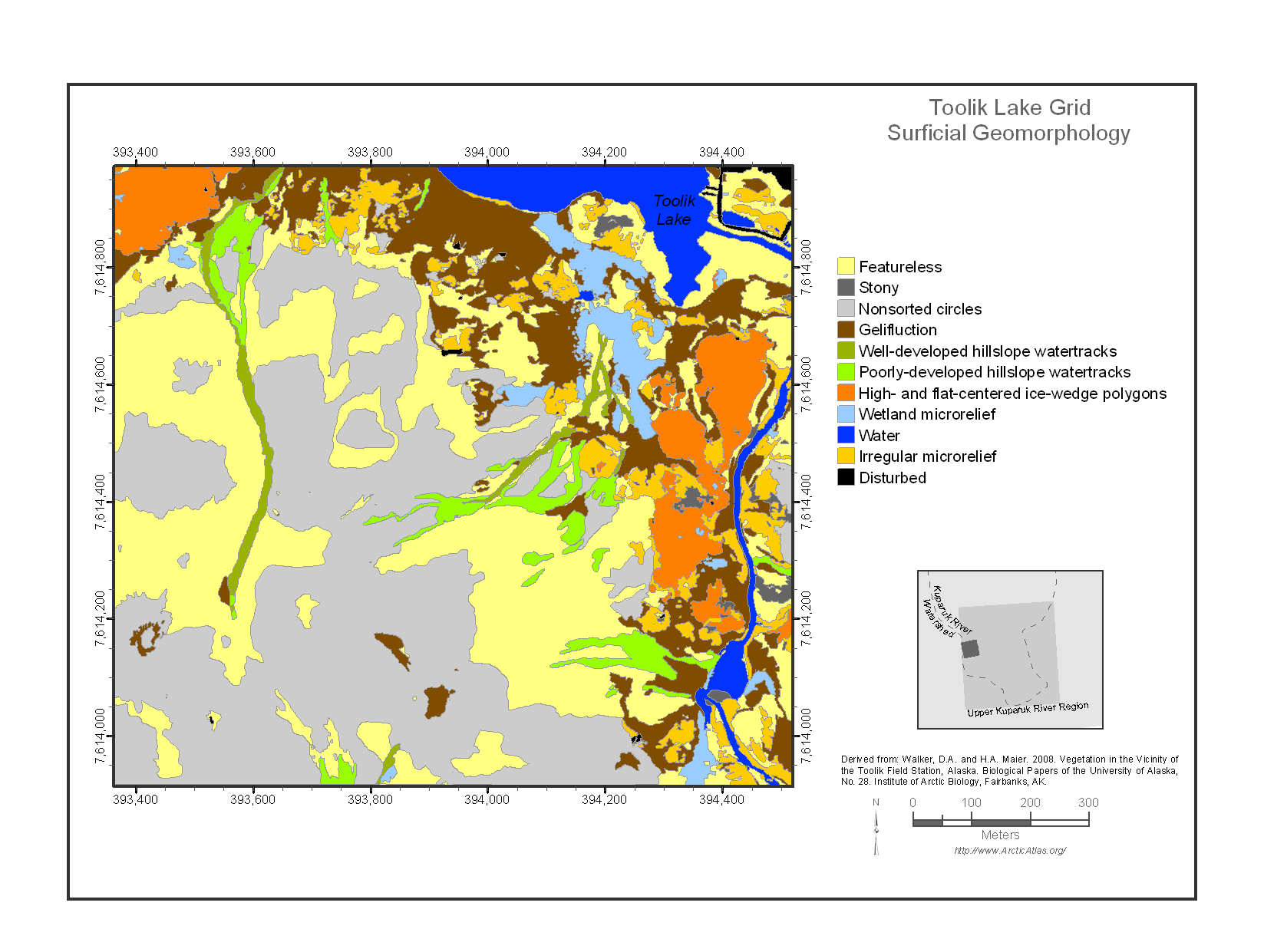
Maps of Vegetation Types and Physiographic Features, Toolik Lake Area, Alaska
National Aeronautics and Space Administration —
This data set provides the spatial distributions of vegetation types, soil carbon, and physiographic features in the Toolik Lake area, Alaska. Specific attributes... -
Federal
Rock glacier velocities, Selwyn Mountains, Yukon and NWT, Canada, Version 1
National Aeronautics and Space Administration —
An average of 6 markers were surveyed on each of 15 rock glaciers, once each in 1983 and 1995 using a level (1983) and a theodolite (1995). Measurement error was on... -
Federal
AVIRIS-Classic: L2 Calibrated Reflectance, Facility Instrument Collection, V1
National Aeronautics and Space Administration —
This dataset contains Level 2 (L2) orthocorrected reflectance from the Airborne Visible / Infrared Imaging Spectrometer (AVIRIS-Classic) instrument. This is the NASA... -
Federal
SWOT Level 2 Radiometer Brightness Temperatures and Troposphere Interim Data Product Version 1.0
National Aeronautics and Space Administration —
The SWOT Level 2 Radiometer Brightness Temperatures and Troposphere Interim Geophysical Data Record (IGDR) Version 1.0 dataset produced by the Surface Water and Ocean... -
Federal
AVIRIS-Classic: L1B Calibrated Radiance, Facility Instrument Collection, V1
National Aeronautics and Space Administration —
This dataset contains Level 1B (L1B) orthocorrected, scaled radiance image files as well as files of observational geometry and illumination parameters and supporting... -
Federal
MGN V RDRS DERIVED DIGITAL IMAGE MAP DATA RECORD V1.0
National Aeronautics and Space Administration —
This data set contains the Magellan the FMAP, a full-resolution (75 meters/pixel) global mosaic, produced by the U.S. Geological Survey from Magellan F-BIDR data. The... -
Federal
MGN V RDRS DERIVED DIGITAL IMAGE MAP DATA RECORD V1.0
National Aeronautics and Space Administration —
This data set contains the Magellan the FMAP, a full-resolution (75 meters/pixel) global mosaic, produced by the U.S. Geological Survey from Magellan F-BIDR data. The... -
Federal
Permafrost Map for Northwestern Canada (Mackenzie Region), Version 1
National Aeronautics and Space Administration —
The Permafrost Map for Northwestern Canada (Mackenzie Region) is a digital version of the 1:1,000,000 map produced by Heginbottom and Radburn [Heginbottom, J.A. and... -
Federal
SHIFT: AVIRIS-NG L1A Unrectified Radiance
National Aeronautics and Space Administration —
This dataset contains Level 1A (L1A) unrectified surface radiance image files as well as files of observational geometry and illumination parameters and supporting... -
Federal
ENVISAT MERIS Global Mapped CyAN Project, True Color (TC) Data, version 5.0
National Aeronautics and Space Administration —
Cyanobacteria Assessment Network (CyAN) is a multi-agency project among EPA, the National Aeronautics and Space Administration (NASA), the National Oceanic and... -
Federal
HLS Sentinel-2 Multi-spectral Instrument Surface Reflectance Daily Global 30m v2.0
National Aeronautics and Space Administration —
The Harmonized Landsat Sentinel-2 (HLS) project provides consistent surface reflectance data from the Operational Land Imager (OLI) aboard the joint NASA/USGS Landsat... -
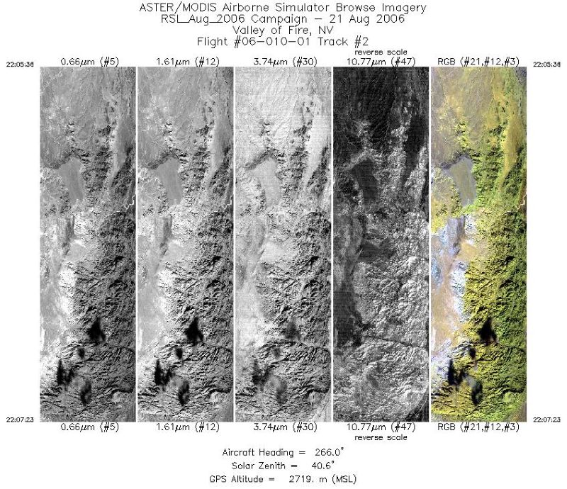
Federal
MASTER: Airborne Science, Southwest US, August 2006
National Aeronautics and Space Administration —
This dataset includes Level 1B (L1B) data products from the MODIS/ASTER Airborne Simulator (MASTER) instrument. The spectral data were collected during 18 flights...

Official websites use .gov
A
.gov website belongs to an official government
organization in the United States.
Secure .gov websites use HTTPS
A
lock (
) or https:// means you’ve safely connected to
the .gov website. Share sensitive information only on official,
secure websites.