
-
Federal
Thermal-Inertial UAV Night Dataset
National Aeronautics and Space Administration —
Thermal-Inertial UAV Night Dataset -
Federal
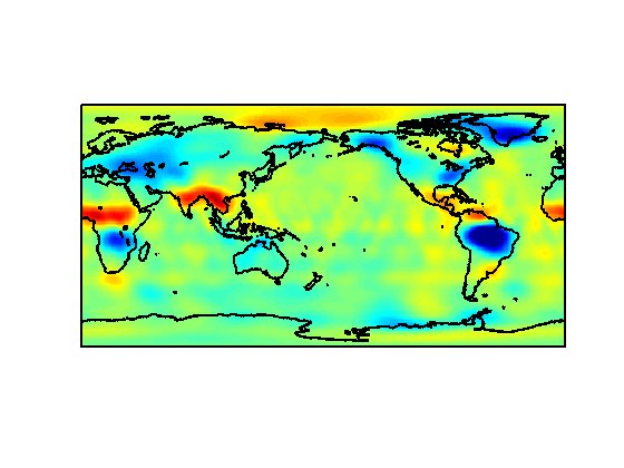
Global Annual PM2.5 Grids from MODIS, MISR and SeaWiFS Aerosol Optical Depth (AOD), 1998-2019, V4.GL.03 NGDA
National Aeronautics and Space Administration —
The Global Annual PM2.5 Grids from MODIS, MISR and SeaWiFS Aerosol Optical Depth (AOD), 1998-2019, V4.GL.03 consists of annual concentrations (micrograms per cubic... -
Federal
Georeferenced U.S. County-Level Population Projections, Total and by Sex, Race and Age, Based on the SSPs, 2020-2100
National Aeronautics and Space Administration —
The Georeferenced U.S. County-Level Population Projections, Total and by Sex, Race and Age, Based on the SSPs, 2020-2100 consists of county-level population... -
Federal
High Resolution Empirical Tide Prediction Software Version 14
National Aeronautics and Space Administration —
This dataset provides sea surface height and ocean surface currents associated with the predictable astronomical tide at the M2, S2, N2, K1, and O1 frequencies. The... -
Federal
Catalog of NASA-Related Case Studies
National Aeronautics and Space Administration —
The OCKO has developed over 50 case studies to enhance learning at workshops, training, retreats and conferences. Case studies make mission knowledge attractive and... -
Federal
PDS Software Release Nasaview (3.10.0)
National Aeronautics and Space Administration —
Software release 3.10.0 -
Federal
MLS/Aura Near-Real-Time L2 Water Vapor (H2O) Mixing Ratio V005 (ML2H2O_NRT) at GES DISC
National Aeronautics and Space Administration —
ML2H2O_NRT is the EOS Aura Microwave Limb Sounder (MLS) Near-Real-Time (NRT) product for water vapor (H2O). This product contains H2O profiles derived from the 190... -
Federal
Gazetteer of Planetary Nomenclature
National Aeronautics and Space Administration —
Planetary nomenclature, like terrestrial nomenclature, is used to uniquely identify a feature on the surface of a planet or satellite so that the feature can be... -
Federal
LRO MOON CRATER EDR RAWDATA VERSION 1.0
National Aeronautics and Space Administration —
This data set comprises the raw binary data from from the LRO Cosmic Ray Telescope for the Effects of Radiation (CRaTER) instrument. The data consists of the... -
Federal
Sentinel-1 Interferograms - Coherence (BETA)
National Aeronautics and Space Administration —
Sentinel-1 SLC interferometric products generated by JPL using ISCE v2.0.0, delivered by ASF -
Federal
Extra-vehicular Activity (EVA) - US and Russia
National Aeronautics and Space Administration —
Activities done by an astronaut or cosmonaut outside a spacecraft beyond the Earth's appreciable atmosphere. -
Federal
ASTEROID PROPER ELEMENTS V1.0
National Aeronautics and Space Administration —
Proper elements of asteroids are derived from the osculating orbital elements by correcting for the perturbations of the major planets to arrive at elements which are... -
Federal
Daily and Annual PM2.5 Concentrations for the Contiguous United States, 1-km Grids, v1 (2000 - 2016)
National Aeronautics and Space Administration —
The Daily and Annual PM2.5 Concentrations for the Contiguous United States, 1-km Grids, v1 (2000 - 2016) data set includes predictions of PM2.5 concentrations in grid... -
Federal
PDS Chandrayaan-1 Moon Mineralogy Mapper (M3) Release 3
National Aeronautics and Space Administration —
M3 -
Federal
West Africa Coastal Vulnerability Mapping: Population Projections, 2030 and 2050
National Aeronautics and Space Administration —
The West Africa Coastal Vulnerability Mapping: Population Projections, 2030 and 2050 data set is based on an unreleased working version of the Gridded Population of... -
Federal
Low Elevation Coastal Zone (LECZ) Urban-Rural Population and Land Area Estimates, Version 3
National Aeronautics and Space Administration —
The Low Elevation Coastal Zone (LECZ) Urban-Rural Population and Land Area Estimates, Version 3 data set contains land areas with urban, quasi-urban, rural, and total... -
Federal
Landsat 2000
National Aeronautics and Space Administration —
Landsat.org, an affiliate of the Tropical Rain Forest Information Center (TRFIC), now hosts the Global Orthorectified Landsat Datasets for four epochs: 1970's MSS,... -
Federal
Asteroid Lightcurve Database (LCDB) V3.0
National Aeronautics and Space Administration —
The asteroid lightcurve database (LCDB) is one of the more widely-used research tools for those doing research that compares and contrasts physical characteristics of... -
Federal
Last of the Wild Project, Version 2, 2005 (LWP-2): Global Human Footprint Dataset (Geographic)
National Aeronautics and Space Administration —
The Global Human Footprint Dataset of the Last of the Wild Project, Version 2, 2005 (LWP-2) is the Human Influence Index (HII) normalized by biome and realm. The HII...

Official websites use .gov
A
.gov website belongs to an official government
organization in the United States.
Secure .gov websites use HTTPS
A
lock (
) or https:// means you’ve safely connected to
the .gov website. Share sensitive information only on official,
secure websites.