
-
Federal
BINARY MINOR PLANETS V8.0
National Aeronautics and Space Administration —
The data set lists orbital and physical properties for well-observed or suspected binary/multiple minor planets including the Pluto system, compiled from the... -
Federal
Estimation of Faults in DC Electrical Power System
National Aeronautics and Space Administration —
This paper demonstrates a novel optimizationbased approach to estimating fault states in a DC power system. The model includes faults changing the circuit topology... -
Federal
SDO/AIA Carrington Maps
National Aeronautics and Space Administration —
Synoptic (or Carrington) Map PNG images created from EUV images observed by the Atmospheric Imaging Assembly (AIA) on the Solar Dynamics Observatory (SDO). Maps are... -
Federal
JUNO E/J/S/SS WAVES EXPERIMENT DATA RECORDS V1.0
National Aeronautics and Space Administration —
The Juno Waves EDR complete data set includes all Waves science and housekeeping data for the entire Juno mission. This data set consists of reformatted,... -
Federal
Large Quasar Astrometric Catalog, 3rd Release
National Aeronautics and Space Administration —
Since the release of the original Large Quasar Astrometric Catalog (LQAC: Souchay et al. 2009, A&A, 494, 815), a large number of quasars have been discovered... -
Federal
VOYAGER 1 SOLAR WIND MAGNETIC FIELD HGCOORDS HOUR AVGS V1.0
National Aeronautics and Space Administration —
This dataset contains Voyager 1 magnetometer data from the interplanetary cruise averaged to 1 hour samples in Heliographic coordinates. -
Federal
PENGUIn-3 (PG3) Ground-based Vector Magnetic Field (L2) 1.0 s Data
National Aeronautics and Space Administration —
PENGUIn-3, Antarctica, Ground-based Vector Magnetic Field Level 2 Data, 1.0 s Time Resolution, Station Code: (PG3), Station Location: (GEO Latitude -84.8, Longitude... -
Federal
Regridded Harmonized World Soil Database v1.2
National Aeronautics and Space Administration —
This data set describes select global soil parameters from the Harmonized World Soil Database (HWSD) v1.2, including additional calculated parameters such as area... -
Federal
Supporting Shellfish Aquaculture in the Chesapeake Bay using Artificial Intelligence to Detect Poor Water Quality through Sampling and Remote Sensing
National Aeronautics and Space Administration —
This use-inspired NASA AIST project collects biological, chemical, and physical variables in and above the water at Chesapeake Bay sites for analysis within the lab.... -
Federal
CNOFS CINDI IVM 500 ms Ion Drift Data
National Aeronautics and Space Administration —
This data set contains plasma parameters of the equatorial F-region in the ionosphere measured by the Ion Velocity Meter (IVM) of the Coupled Ion-Neutral Dynamics... -
Federal
Moderate Resolution Imaging Spectroradiometer (MODIS) - Aqua NGDA
National Aeronautics and Space Administration —
This dataset represents multiple products archived at the multiple archive centers for the MODIS (Moderate Resolution Imaging Spectroradiometer) instrument aboard the... -
Federal
Population Exposure Estimates in Proximity to Nuclear Power Plants, Country-Level Aggregates
National Aeronautics and Space Administration —
The Population Exposure Estimates in Proximity to Nuclear Power Plants, Country-Level Aggregates data set consists of country-level estimates of total, urban, and... -
Federal
VIIRS/NPP Land Surface Temperature/Emissivity Daily L3 Global 1km SIN Grid Night V001
National Aeronautics and Space Administration —
The VNP21A1N VIIRS Version 1 data product was decommissioned on April 8th, 2025. Users are encouraged to use Version 2 data products, which provide better calibration... -
Federal
Blind Source Separation
National Aeronautics and Space Administration —
Blind source separation in Simulink using STFT and inverse STFT (Signal processing blockset). -
Federal
Global Rural-Urban Mapping Project, Version 1 (GRUMPv1): Land and Geographic Unit Area Grids
National Aeronautics and Space Administration —
The Global Rural-Urban Mapping Project, Version 1 (GRUMPv1): Land and Geographic Unit Area Grids measure land areas in square kilometers and the mean Unit size... -
Federal
CDDIS_LLR_data
National Aeronautics and Space Administration —
Lunar Laser Ranging (LLR) measures the distance between the Earth and the Moon using laser ranging. A short pulse of coherent light generated by a laser (Light... -
Federal
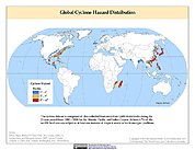
Global Cyclone Hazard Frequency and Distribution
National Aeronautics and Space Administration —
The Global Cyclone Hazard Frequency and Distribution is a 2.5 minute grid based on more than 1,600 storm tracks for the period 1 January 1980 through 31 December 2000... -
Federal
NASA 3D Models: Jason 1
National Aeronautics and Space Administration —
Jason 1 is an oceanography mission to monitor global ocean circulation, study the ties between the oceans and atmosphere, improve global climate forecasts and... -
Federal
HANPP Collection: Human Appropriation of Net Primary Productivity as a Percentage of Net Primary Productivity
National Aeronautics and Space Administration —
The HANPP Collection: Human Appropriation of Net Primary Productivity as a Percentage of Net Primary Productivity represents a map identifying regions in which human... -
Federal
Reduced-Resolution Radar Imagery, Digital Elevation Models, and Related GIS Layers for Barrow, Alaska, USA, Version 1
National Aeronautics and Space Administration —
This product set contains reduced-resolution Interferometric Synthetic Aperture Radar (IFSAR) imagery and geospatial data for the Barrow Peninsula (155.39 - 157.48...

Official websites use .gov
A
.gov website belongs to an official government
organization in the United States.
Secure .gov websites use HTTPS
A
lock (
) or https:// means you’ve safely connected to
the .gov website. Share sensitive information only on official,
secure websites.