
-
Federal
CMS: Terrestrial Carbon Stocks, Emissions, and Fluxes for Conterminous US, 2001-2016 NGDA recent views
National Aeronautics and Space Administration —
This dataset provides estimates of carbon pools, fluxes, and associated uncertainties across the contiguous USA (CONUS) at 0.5-degree resolution for all terrestrial... -
Federal
ISLSCP II MODIS (Collection 4) IGBP Land Cover, 2000-2001 NGDA recent views
National Aeronautics and Space Administration —
This data set, ISLSCP II MODIS (Collection 4) IGBP Land Cover, 2000-2001, contains global land cover classifications (dominant type, classification confidence and... -
Federal
LBA-ECO LC-22 Field Validation of MODIS Deforestation Detection, Brazil, 2005 NGDA recent views
National Aeronautics and Space Administration —
This data set contains field observations, corresponding GPS points, and point and polygons of deforested areas in the state of Mato Grosso, Brazil, for the period... -
Federal
ABoVE: Light-Curve Modelling of Gridded GPP Using MODIS MAIAC and Flux Tower Data NGDA recent views
National Aeronautics and Space Administration —
This dataset contains gridded estimations of daily ecosystem Gross Primary Production (GPP) in grams of carbon per day at a 1 km2 spatial resolution over Alaska and... -
Federal
ABoVE: Active Layer Thickness from Remote Sensing Permafrost Model, Alaska, 2001-2015 NGDA recent views
National Aeronautics and Space Administration —
This dataset provides annual estimates of active layer thickness (ALT) at 1 km resolution across Alaska from 2001-2015. The ALT was estimated using a remote sensing-... -
Federal
ISLSCP II Monthly Snow-Free Albedo, 1982-1998, and Background Soil Reflectance NGDA recent views
National Aeronautics and Space Administration —
This data set contains monthly average snow-free surface shortwave albedo calculated for the period 1982-1998 and estimates of background soil/litter reflectances in... -
Federal
MODIS-derived Vegetation and Albedo Parameters for Agroecosystem-Climate Modeling NGDA recent views
National Aeronautics and Space Administration —
This dataset provides MODIS-derived leaf area index (LAI), stem area index (SAI), vegetation area fraction, dominant landcover category, and albedo parameters for the... -
Federal
Carbon Pools across CONUS using the MaxEnt Model, 2005, 2010, 2015, 2016, and 2017 NGDA recent views
National Aeronautics and Space Administration —
This dataset provides annual estimates of six carbon pools, including forest aboveground live biomass, belowground biomass, aboveground dead biomass, belowground dead... -
Federal
Synthesis of Winter In Situ Soil CO2 Flux in pan-Arctic and Boreal Regions, 1989-2017 NGDA recent views
National Aeronautics and Space Administration —
This dataset provides a synthesis of winter ( September-April) in situ soil CO2 flux measurement data from locations across pan-Arctic and Boreal permafrost regions.... -
Federal
Global Fire Atlas with Characteristics of Individual Fires, 2003-2016 NGDA recent views
National Aeronautics and Space Administration —
The Global Fire Atlas is a global dataset that tracks the day-to-day dynamics of individual fires to determine the timing and location of ignitions, fire size,... -
Federal
Russian Boreal Forest Disturbance Maps Derived from Landsat Imagery, 1984-2000 NGDA recent views
National Aeronautics and Space Administration —
This data set provides Boreal forest disturbance maps at 30-m resolution for 55 selected sites across Northern Eurasia within the Russian Federation. Disturbance... -
Federal
Global Monthly Mean Leaf Area Index Climatology, 1981-2015 NGDA recent views
National Aeronautics and Space Administration —
This dataset provides a global 0.25 degree x 0.25 degree gridded monthly mean leaf area index (LAI) climatology as averaged over the period from August 1981 to August... -
Federal
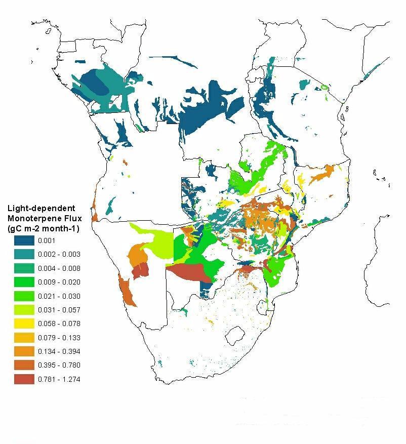
SAFARI 2000 Estimated BVOC Emissions for Southern African Land Cover Types NGDA recent views
National Aeronautics and Space Administration —
Improved vegetation distribution and emission data for Africa south of the equator were developed for the Southern African Regional Science Initiative (SAFARI 2000)... -
Federal
LBA-ECO LC-24 Forest Cover Map from MODIS, 500-m, South America: 2001 NGDA recent views
National Aeronautics and Space Administration —
This data set, LBA-ECO LC-24 Forest Cover Map from MODIS, 500-m, South America: 2001, contains forest cover information for 2001 for all of South America. The data... -
Federal
ABoVE: Environmental Conditions During Fall Moose Hunting Seasons, Alaska, 2000-2016 NGDA recent views
National Aeronautics and Space Administration —
This dataset provides daily and annual air temperature, river water level, and leaf drop dates coincident with the moose (Alces alces) hunting season (September) for... -
Federal
ABoVE: Dall Sheep Response to Snow and Landscape Covariates, Alaska, 2005-2008 NGDA recent views
National Aeronautics and Space Administration —
This dataset provides daily estimates of snow depth and snow density for the study area in Lake Clark National Park and Preserve (LCNPP), Alaska. The data were... -
Federal
ISLSCP II Snow-Free, Spatially Complete, 16 Day Albedo, 2002 NGDA recent views
National Aeronautics and Space Administration —
This data set, ISLSCP II Snow-Free, Spatially Complete, 16 Day Albedo, 2002, contains 9 files for snow-free, spatially complete 16-day global black-sky albedos at... -
Federal
SAFARI 2000 MODIS Water and Heat Fluxes, Maun, Botswana, Dry Season 2001 NGDA recent views
National Aeronautics and Space Administration —
A physically-based model, Energy: Surface Towards Atmosphere (ESTA), was used to model and map the energy and water balances of a heterogeneous land surface in a... -
Federal
ISLSCP II Historical Croplands Cover, 1700-1992 NGDA recent views
National Aeronautics and Space Administration —
The Historical Croplands Cover data set was developed to understand the consequences of historical changes in land use and land cover for ecosystem goods and... -
Federal
SAFARI 2000 1-Degree Estimates of Burned Biomass, Area, and Emissions, 2000 NGDA recent views
National Aeronautics and Space Administration —
A new method is used to generate spatial estimates of monthly averaged biomass burned area and spatial and temporal estimates of trace gas and aerosol emissions from...

Official websites use .gov
A
.gov website belongs to an official government
organization in the United States.
Secure .gov websites use HTTPS
A
lock (
) or https:// means you’ve safely connected to
the .gov website. Share sensitive information only on official,
secure websites.