
-
Federal
Global Food Security-support Analysis Data (GFSAD) Cropland Extent 2015 South Asia, Afghanistan, and Iran product 30 m V001
National Aeronautics and Space Administration —
The NASA Making Earth System Data Records for Use in Research Environments (MEaSUREs) Global Food Security-support Analysis Data (GFSAD) data product provides... -
Federal
Delta-X: NUMAR Predictive Model for Marsh Accretion Rates and Chemical Properties
National Aeronautics and Space Administration —
This dataset provides input data and model code to run the Marsh Accretion Rates (NUMAR) process model used to predict soil accretion rates and chemical properties... -
Federal
Delta-X: In Situ Water Surface Reflectance across MRD, LA, USA, 2021, V3
National Aeronautics and Space Administration —
This dataset includes above water measurements of remote-sensing reflectance measured in situ at field sampling stations during the Delta-X 2021 field efforts.... -
Federal
nu-Anomica algorithm
National Aeronautics and Space Administration —
One-class nu-Support Vector machine (SVMs) learning technique maps the input data into a much higher dimensional space and then uses a small portion of the training... -
Federal
Tropical Cloud-Precip (hybrid) Regime, Pr6x1 set
National Aeronautics and Space Administration —
Cloud-Precipitation Hybrid Regimes with MODIS C6.1 2D joint histogram of CTP and COT (total 42 bins) and IMERG v06B precipitation histogram (total 6 bins) derived in... -
Federal
Helicopter MMR Reflectance Data (SNF)
National Aeronautics and Space Administration —
A major aspect of the ground data collection effort in the SNF during the summers of 1983 and 1984 was the acquisition of helicopter canopy reflectance measurements.... -
Federal
A Global Database of Litterfall Mass and Litter Pool Carbon and Nutrients
National Aeronautics and Space Administration —
Measurement data of aboveground litterfall and littermass and litter carbon, nitrogen, and nutrient concentrations were extracted from 685 original literature sources... -
Federal
SORCE XPS Level 4 Solar Spectral Irradiance 1.0nm Res 24-Hour Means V012 (SOR4XPSD_LOW) at GES DISC
National Aeronautics and Space Administration —
The SORCE XPS Level 4 Solar Spectral Irradiance 1.0nm Res 24-Hour Means product (SOR4XPSD_LOW) contains modelled spectral extreme ultraviolet (XUV) irradiances based... -
Federal
NLCD 1992/2001 Retrofit Land Cover Change Product
National Aeronautics and Space Administration —
Developments in mapping methodology, new sources of input data, and changes in the mapping legend for the 2001 National Land Cover Database (NLCD2001) will confound... -
Federal
Archive of Census Related Products (ACRP): 1990 ZIP Equivalency Files
National Aeronautics and Space Administration —
The 1990 Zip Equivalency Files portion of the Archive of Census Related Products (ACRP) contains population and housing data derived from the U.S. Census Bureau's... -
Federal
NACP Integrated Wildland and Cropland 30-m Fuel Characteristics Map, U.S.A., 2010
National Aeronautics and Space Administration —
The data set provides a 30-m comprehensive fuelbed characteristics map for both the wildland and cropland areas of the conterminous United States (CONUS) for 2010.... -
Federal
Global Soil Types, 0.5-Degree Grid (Modified Zobler)
National Aeronautics and Space Administration —
A global data set of soil types is available at 0.5-degree latitude by 0.5-degree longitude resolution. There are 106 soil units, based on Zobler?s (1986) assessment... -
Federal
Global Hyperspectral Imaging Spectral-library of Agricultural crops for Central Asia V001
National Aeronautics and Space Administration —
The Global Hyperspectral Imaging Spectral-library of Agricultural crops (GHISA) is a comprehensive compilation, collation, harmonization, and standardization of... -
Federal
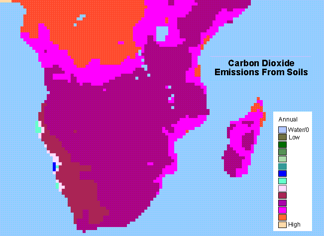
SAFARI 2000 Monthly and Annual CO2 Emissions from Soil, 0.5 Degree Grid
National Aeronautics and Space Administration —
The data set provides estimated monthly and annual soil CO2 emissions for southern Africa (the SAFARI 2000 project region). The calculated emissions are from the... -
Federal
SiB3 Modeled Global 1-degree Hourly Biosphere-Atmosphere Carbon Flux, 1998-2006
National Aeronautics and Space Administration —
The Simple Biosphere Model, Version 3 (SiB3) was used to produce a global data set of hourly carbon fluxes between the atmosphere and the terrestrial biosphere for... -
Federal
Ecosystem Demography Model: Scaling Vegetation Dynamics Across South America
National Aeronautics and Space Administration —
This model product contains the source code for the Ecosystem Demography Model (ED version 1.0) as well as model input and output data for a portion of South America... -
Federal
BOREAS Site and Area Geographic Coordinate Information
National Aeronautics and Space Administration —
In an effort to properly document the sites and areas where data were collected, personnel of the BOReal Ecosystem-Atmosphere Study (BOREAS) Information System... -
Federal
BOREAS TE-18 Geosail Canopy Reflectance Model
National Aeronautics and Space Administration —
The SAIL (Scattering from Arbitrarily Inclined Leaves) model was combined with the Jasinski geometric model to simulate canopy spectral reflectance and absorption of...

Official websites use .gov
A
.gov website belongs to an official government
organization in the United States.
Secure .gov websites use HTTPS
A
lock (
) or https:// means you’ve safely connected to
the .gov website. Share sensitive information only on official,
secure websites.