
-
Federal
LBA-ECO CD-10 H2O Profiles at km 67 Tower Site, Tapajos National Forest
National Aeronautics and Space Administration —
This data set reports vertical profiles of H2O vapor concentrations measured at the Para Western (Santarem) - km 67, Primary Forest Tower Site (Figure 1). This site... -
Federal
Far Ultraviolet Explorer (FUSE) Observation Log
National Aeronautics and Space Administration —
NASA's FUSE (Far Ultraviolet Spectroscopic Explorer) spacecraft provided spectra in the far-ultraviolet portion of the electromagnetic spectrum (the wavelength range... -
Federal
MODIS/Terra+Aqua Land Cover Type Yearly L3 Global 0.05Deg CMG V061
National Aeronautics and Space Administration —
The Terra and Aqua combined Moderate Resolution Imaging Spectroradiometer (MODIS) Land Cover Climate Modeling Grid (CMG) (MCD12C1) Version 6.1 data product provides a... -
Federal
Magnetically-coupled microcalorimeter arrays for x-ray astrophysics with sub-eV spectral resolution and large format capability Project
National Aeronautics and Space Administration —
"We propose to develop a revolutionary x-ray camera for astrophysical imaging spectroscopy. High-resolution x-ray spectroscopy is a powerful tool for studying the... -
Federal
Expandable Variable-Autonomy Architecture Project
National Aeronautics and Space Administration —
Effective multi-level autonomous piloting systems require integration with safety-critical functions. The Expandable Variable-Autonomy... -
Federal
TRMM Ground Validation Calibrated QC Radar Reflectivity Full Volume Scan L1C 1 hour V7 (TRMM_1C51UW) at GES DISC
National Aeronautics and Space Administration —
This dataset is part of the University of Washington TRMM Ground Validation products. Files are in "Universal Format", described in BAMS, Vol 61, No 11, November... -
Federal
Archive of Census Related Products (ACRP): 1990 Public Use Microdata Sample Areas (PUMA) Boundary Files
National Aeronautics and Space Administration —
The 1990 Public Use Microdata Sample Areas (PUMA) Boundary Files portion of the Archive of Census Related Products (ACRP) consists of 5% sample (apuma) and 1% sample... -
Federal
Voyager 1 Plasma Wave Subsystem (PWS), 16-Channel Spectrum Analyzer Data
National Aeronautics and Space Administration —
This data set contains Voyager 1 Plasma Wave Subsystem (PWS) electric field 16-channel Spectrum Analyzer (SA) data for the entire mission in calibrated CDF files. As... -
Federal
Voyager 2 Plasma Wave Subsystem (PWS), 16-Channel Spectrum Analyzer Data
National Aeronautics and Space Administration —
This data set contains Voyager 2 Plasma Wave Subsystem (PWS) electric field 16-channel Spectrum Analyzer (SA) data for the entire mission in calibrated CDF files. As... -
Federal
Small Magellanic Cloud XMM-Newton Point Source Catalog
National Aeronautics and Space Administration —
The XMM-Newton survey of the Small Magellanic Cloud (SMC) yielded complete coverage of the bar and eastern wing in the 0.2-12.0 keV energy band. In addition to the... -
Federal
GPM Ground Validation Doppler on Wheels (DOW) OLYMPEX V2
National Aeronautics and Space Administration —
The GPM Ground Validation Doppler on Wheels (DOW) OLYMPEX V2 dataset was obtained by a dual-polarization and dual-frequency X-band mobile radar operated by the Center... -
Federal
EASE-Grid 2.0 Land-Ocean-Coastline-Ice Masks Derived from Boston University MODIS/Terra Land Cover Data, Version 1
National Aeronautics and Space Administration —
These Land-Ocean-Coastline-Ice (LOCI) files provide land classification masks derived from the Boston University MOD12Q1 V004 MODIS/Terra 1 km Land Cover Product... -
Federal
MODIS/Aqua Near Real Time (NRT) Calibrated Radiances 5-Min L1B Swath 1km
National Aeronautics and Space Administration —
The MODIS Level 1B Near Real Time (NRT) data set contains calibrated and geolocated at-aperture radiances for 36 discrete bands located in the 0.4 to 14.4 micron... -
Federal
U.S. Census Grids (Summary File 1), 1990: Metropolitan Statistical Areas
National Aeronautics and Space Administration —
The U.S. Census Grids (Summary File 1), 1990: Metropolitan Statistical Areas data set contains grids of demographic and socioeconomic data from the year 1990 U.S.... -
Federal
M 16 (Eagle Nebula) Chandra X-Ray Point Source Catalog
National Aeronautics and Space Administration —
Mechanisms regulating the origin of X-rays in young stellar objects and the correlation with their evolutionary stage are under debate. Studies of the X-ray... -
Federal
Harmonic Constants for Baroclinic Tide Prediction
National Aeronautics and Space Administration —
This dataset of Harmonic Constants for Baroclinic Tide Prediction was produced by Edward Zaron (Oregon State University) and Shane Elipot (University of Miami). It... -
Federal
Archive of Census Related Products (ACRP): 1990 Census Block Statistics
National Aeronautics and Space Administration —
The 1990 Census Block Statistics portion of the Archive of Census Related Products (ACRP) contains population and housing data from the U.S. Census Bureau's 1990... -
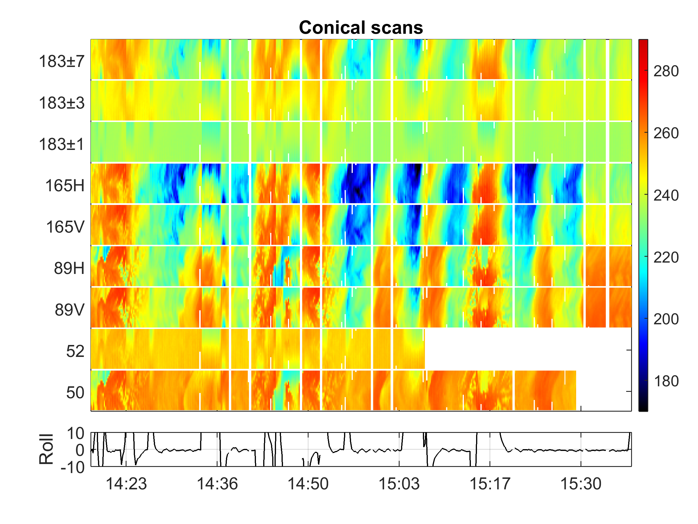
Federal
GPM Ground Validation Conical Scanning Millimeter-wave Imaging Radiometer (CoSMIR) OLYMPEX V1
National Aeronautics and Space Administration —
The GPM Ground Validation Conical Scanning Millimeter-wave Imaging Radiometer (CoSMIR) OLYMPEX dataset consists of brightness temperatures from 9 channels as measured... -
Federal
NLDAS VIC Land Surface Model L4 Hourly 0.125 x 0.125 degree V2.0 (NLDAS_VIC0125_H) at GES DISC
National Aeronautics and Space Administration —
This data set contains forty-four fields simulated from the VIC land-surface model (LSM) for Phase 2 of the North American Land Data Assimilation System (NLDAS-2).... -
Federal
SnowEx23 University of Wyoming Ground Penetrating Radar V001
National Aeronautics and Space Administration —
This data set contains the results of 1 GHz ground-penetrating radar surveys conducted at the Arctic Coastal Plain (ACP) site and the Upper Kuparuk/Toolik (UKT) site...

Official websites use .gov
A
.gov website belongs to an official government
organization in the United States.
Secure .gov websites use HTTPS
A
lock (
) or https:// means you’ve safely connected to
the .gov website. Share sensitive information only on official,
secure websites.