
-
Federal
Pan-STARRS DR1 Catalog ConeSearch
National Aeronautics and Space Administration —
Pan-STARRS is a system for wide-field astronomical imaging developed and operated by the Institute for Astronomy at the University of Hawaii. Pan-STARRS1 (PS1) is the... -
Federal
Multi-Global Navigation Satellite System (GNSS) Broadcast Ephemeris Data (daily files) from NASA CDDIS
National Aeronautics and Space Administration —
This dataset consists of ground-based multi-GNSS (Global Navigation Satellite System) Broadcast Ephemeris Data. GNSS satellites provide autonomous geo-spatial... -
Federal
Effects of Climate Change on Global Food Production from SRES Emissions and Socioeconomic Scenarios
National Aeronautics and Space Administration —
The Effects of Climate Change on Global Food Production from SRES Emissions and Socioeconomic Scenarios is an update to a major crop modeling study by the NASA... -
Federal
Compendium of Environmental Sustainability Indicator Collections: 2004 Environmental Vulnerability Index (EVI)
National Aeronautics and Space Administration —
The 2004 Environmental Vulnerability Index (EVI) portion of the Compendium of Environmental Sustainability Indicator Collections contains 111 variables for 235... -
Federal
2012 Environmental Performance Index and Pilot Trend Environmental Performance Index
National Aeronautics and Space Administration —
The 2012 Environmental Performance Index (EPI) ranks 132 countries on 22 performance indicators in the following 10 policy categories: environmental burden of... -
Federal
China Dimensions Data Collection: Fundamental GIS: Digital Chart of China, 1:1M, Version 1
National Aeronautics and Space Administration —
The Fundamental GIS: Digital Chart of China, 1:1M, Version 1 consists of vector maps of China and surrounding areas. The maps include roads, railroads, drainage... -
Federal
Compendium of Environmental Sustainability Indicator Collections: The Wellbeing of Nations
National Aeronautics and Space Administration —
The Wellbeing of Nations portion of the Compendium of Environmental Sustainability Indicator Collections contains a subset of 123 variables assembled from the... -
Federal
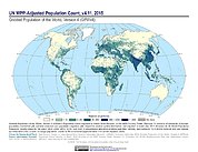
Gridded Population of the World, Version 4 (GPWv4): Population Density Adjusted to Match 2015 Revision UN WPP Country Totals, Revision 11
National Aeronautics and Space Administration —
The Gridded Population of the World, Version 4 (GPWv4): Population Density Adjusted to Match 2015 Revision of UN WPP Country Totals, Revision 11 consists of estimates... -
Federal
Global 15 x 15 Minute Grids of the Downscaled Population Based on the SRES B2 Scenario, 1990 and 2025
National Aeronautics and Space Administration —
The Global 15x15 Minute Grids of the Downscaled Population Based on the Special Report on Emissions Scenarios (SRES) B2 Scenario, 1990 and 2025, are geospatial... -
Federal
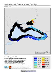
Indicators of Coastal Water Quality: Change in Chlorophyll-a Concentration 1998-2007
National Aeronautics and Space Administration —
The Change in Chlorophyll-a Concentrations 1998-2007 component of the Indicators of Coastal Water Quality Collection represents a tabular time series of the... -
Federal
Low Elevation Coastal Zone (LECZ) Urban-Rural Population and Land Area Estimates, Version 3
National Aeronautics and Space Administration —
The Low Elevation Coastal Zone (LECZ) Urban-Rural Population and Land Area Estimates, Version 3 data set contains land areas with urban, quasi-urban, rural, and total... -
Federal
Gridded Population of the World, Version 3 (GPWv3): Population Count Grid, Future Estimates
National Aeronautics and Space Administration —
The Gridded Population of the World, Version 3 (GPWv3): Population Count Grid, Future Estimates consists of estimates of human population for the years 2005, 2010,... -
Federal
INFORM Global Risk Index 2019 Mid Year, v0.3.7
National Aeronautics and Space Administration —
The INFORM Global Risk Index 2019 Mid Year, v0.3.7 data set identifies the countries at a high risk of humanitarian crisis that are more likely to require... -
Federal
Annual Land Use and Urban Land Cover: Ethiopia, Nigeria, and South Africa, 2016-2020
National Aeronautics and Space Administration —
This dataset provides a two-tier annual Land Use (LU) and Urban Land Cover (LC) product suite over three African countries, Ethiopia, Nigeria, and South Africa,... -
Federal
GNSS GLONASS Combined Broadcast Ephemeris Data (30-second sampling, daily files) from NASA CDDIS
National Aeronautics and Space Administration —
This dataset consists of ground-based Global Navigation Satellite System (GNSS) GLObal NAvigation Satellite System (GLONASS) Broadcast Ephemeris Data (hourly files)... -
Federal
Landsat-Derived Global Rainfed and Irrigated-Cropland Product 30 m V001
National Aeronautics and Space Administration —
The Landsat-Derived Global Rainfed and Irrigated-Cropland Product (LGRIP) provides high resolution, global cropland data to assist and address food and water security... -
Federal
Gridded Population of the World, Version 3 (GPWv3): Population Density Grid
National Aeronautics and Space Administration —
The Gridded Population of the World, Version 3 (GPWv3): Population Density Grid consists of estimates of human population for the years 1990, 1995, and 2000 by 2.5... -
Federal
Gridded Population of the World, Version 4 (GPWv4): Population Count Adjusted to Match 2015 Revision of UN WPP Country Totals, Revision 11
National Aeronautics and Space Administration —
The Gridded Population of the World, Version 4 (GPWv4): Population Count Adjusted to Match 2015 Revision of UN WPP Country Totals, Revision 11 consists of estimates... -
Federal
2008 Environmental Performance Index (EPI)
National Aeronautics and Space Administration —
The 2008 Environmental Performance Index (EPI) centers on two broad environmental protection objectives: (1) reducing environmental stresses on human health, and (2)...

Official websites use .gov
A
.gov website belongs to an official government
organization in the United States.
Secure .gov websites use HTTPS
A
lock (
) or https:// means you’ve safely connected to
the .gov website. Share sensitive information only on official,
secure websites.