
-
Federal
China Dimensions Data Collection: China Maps Bibliographic Database
National Aeronautics and Space Administration —
The China Maps Bibliographic Database is an historical collection of bibliographic information for more than 400 maps of China. The information resides in a... -
Federal
Vegetation Drought Response Index (VegDRI)
National Aeronautics and Space Administration —
The National Drought Mitigation Center produces VegDRI in collaboration with the US Geological Survey's (USGS) Center for Earth Resources Observation and Science... -
Federal
China Dimensions Data Collection: China Administrative Regions GIS Data: 1:1M, County Level, 1 July 1990
National Aeronautics and Space Administration —
The China Administrative Regions GIS Data: 1:1M, County Level, 1 July 1990 consists of geographic boundary data for the administrative regions of China as of 1 July... -
Federal
AIRSAR_POLSAR_3_FREQ_POLARIMETRY
National Aeronautics and Space Administration —
AIRSAR three-frequency polarimetric frame product -
Federal
NPP Cropland: Gridded Estimates For the Central USA, 1982-1996, R1
National Aeronautics and Space Administration —
This data set contains a single data file (.csv format) that provides gridded values of net primary productivity (NPP) for cropland in eight counties in the central... -
Federal
LBA-ECO CD-06 Physical, Political, and Hydrologic Maps, Ji-Parana River Basin, Brazil
National Aeronautics and Space Administration —
This data set contains physical, hydrologic, political, demographic, and societal maps for the Ji-Parana River Basin, in the state of Rondonia, Brazil. These data... -
Federal
Archive of Census Related Products (ACRP): 1990 Summary Tape File (STF1B)
National Aeronautics and Space Administration —
The 1990 Summary Tape File (STF1B) portion of the Archive of Census Related Products (ACRP) contains population and housing data, along with additional demographic... -
Federal
GAFFEY METEORITE SPECTRA V2.0
National Aeronautics and Space Administration —
Laboratory spectra of meteorite samples, obtained by M. J. Gaffey. -
Federal
AIRSAR_TOPSAR_DEM_P
National Aeronautics and Space Administration —
AIRSAR topographic SAR digital elevation model PTIF product -
Federal
UAVSAR_POLSAR_ML_COMPLEX_SLANT
National Aeronautics and Space Administration —
UAVSAR PolSAR Scene Complex -
Federal
UAVSAR_POLSAR_DEM
National Aeronautics and Space Administration —
UAVSAR PolSAR Scene DEM TIFF -
Federal
UAVSAR_POLSAR_ML_COMPLEX_GRD_5X5
National Aeronautics and Space Administration —
UAVSAR PolSAR Scene Projected Multilook 5x5 -
Federal
UAVSAR_INSAR_AMPLITUDE_GRD
National Aeronautics and Space Administration —
UAVSAR Repeat Pass Interferometry Ground Projected Amplitude Scene -
Federal
UAVSAR_INSAR_METADATA
National Aeronautics and Space Administration —
UAVSAR Repeat Pass Interferometry Scene Metadata -
Federal
Archive of Census Related Products (ACRP): 1990 Standard Extract Files
National Aeronautics and Space Administration —
The 1990 Standard Extract Files portion of the Archive of Census Related Products (ACRP) contains population and housing data derived from the U.S. Census Bureau's... -
Federal
Archive of Census Related Products (ACRP): 1990 SAS Transport Files
National Aeronautics and Space Administration —
The 1990 SAS Transport Files portion of the Archive of Census Related Products (ACRP) contains housing and population data from the U.S. Census Bureau's 1990 Summary... -
Federal
Gaffey Meteorite Spectra V1.0
National Aeronautics and Space Administration —
This data set contains 166 laboratory spectra of 108 meteorite samples, as reported by M. J. Gaffey in Gaffey (1976) [GAFFEY1976]. This in turn was based on his PhD... -
Federal
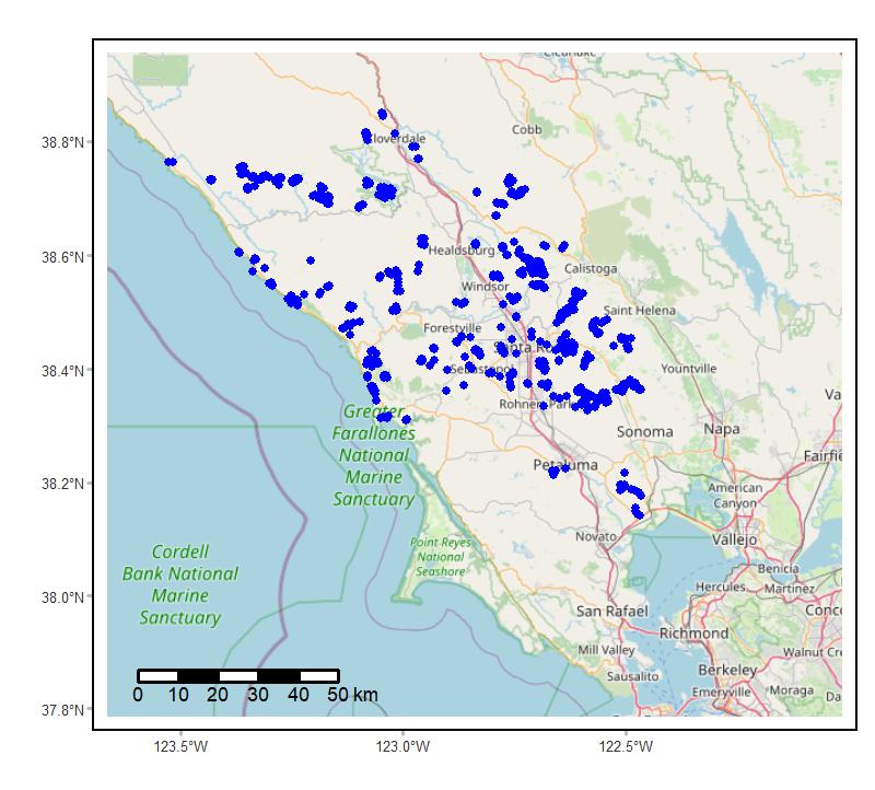
Soundscapes to Landscapes Acoustic Recordings, Sonoma County, CA, 2017-2022
National Aeronautics and Space Administration —
This dataset holds in situ sound recordings from sites in Sonoma County, California, USA as part of the Soundscapes to Landscapes citizen science project. Recordings... -
Federal
OWLETS-2 SERC Research Vessel Data
National Aeronautics and Space Administration —
OWLETS2_Ship_Data_1 is the Ozone Water-Land Environmental Transition Study (OWLETS-2) data collected onboard the Smithsonian Environmental Research Center (SERC)... -
Federal
OWLETS-1 Surface Lidar Data
National Aeronautics and Space Administration —
OWLETS1_SurfaceLidar_Data_1 is the Ozone Water-Land Environmental Transition Study (OWLETS-1) lidar data collected at the NASA Langley Research Center ground site and...

Official websites use .gov
A
.gov website belongs to an official government
organization in the United States.
Secure .gov websites use HTTPS
A
lock (
) or https:// means you’ve safely connected to
the .gov website. Share sensitive information only on official,
secure websites.