
-
Federal
CAR ARMCAS Arctic Cloud BRDF Measurements V2 (CAR_ARMCAS_BRDF) at GES DISC
National Aeronautics and Space Administration —
The Arctic Radiation Measurement in Column Atmosphere-surface System (ARMCAS) was a collaborative research effort between the Cloud and Aerosol Research (CAR) Group,... -
Federal
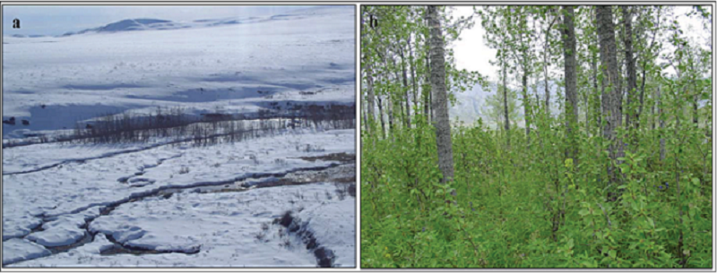
Arctic Vegetation Plots, Poplars, Arctic and Interior AK and YT, Canada, 2003-2005
National Aeronautics and Space Administration —
This data set provides vegetation cover and environmental plot data collected from 32 balsam poplar (Populus balsamifera L., Salicaceae) vegetation plots located on... -
Federal
IBEX High Energy Neutral Atom Imager (ENA-Hi) Data Release-13, Compton Getting, no Survival Probability, Antiram direction, West Ecliptic Pressure and Flux Power Law Slope Maps, Level H3 (H3), annually averaged Data
National Aeronautics and Space Administration —
The IBEX ENA-Hi data sets are from Release 13 of all-sky map data for the first ten years, 2009-2018, in the form of ram direction Hydrogen, H, energetic neutral atom... -
Federal
IBEX High Energy Neutral Atom Imager (ENA-Hi) Data Release-14, Compton Getting corrected, not Survival Probability corrected, Ram direction, West Ecliptic Global Distributed Flux and Flux Power Law Slope Maps, Level H3 (H3), three year average Data
National Aeronautics and Space Administration —
The Interstellar Boundary Explorer, IBEX, has operated in space since 2008 updating our knowledge of the outer heliosphere and its interaction with the local... -
Federal
Ultraluminous X-Ray Sources in Nearby Galaxies Catalog
National Aeronautics and Space Administration —
One hundred and seven ultraluminous X-ray sources (ULXs) with 0.3-10.0 keV luminosities in excess of 1039 erg s-1 are identified in a complete sample of 127 nearby... -
Federal
SDSS NBCKDE Catalog of Photometrically Selected Quasar Candidates
National Aeronautics and Space Administration —
This table contains a catalog of 1,015,082 quasar candidates selected from the photometric imaging data of the Sloan Digital Sky Survey (SDSS) using a non-parametric... -
Federal
Early-Type Galaxies Chandra X-Ray Point Source Catalog
National Aeronautics and Space Administration —
This table contains the results of a Chandra survey of low-mass X-ray binaries (LMXBs) in 24 early-type galaxies. Correcting for detection incompleteness, the X-ray... -
Federal
Sloan Digital Sky Survey (DR5)/XMM-Newton Quasar Survey Catalog
National Aeronautics and Space Administration —
This table contains the 5th Data Release Sloan Digital Sky Survey (DR5 SDSS)/XMM-Newton Quasar Survey Catalog. This catalog contains 792 SDSS DR5 quasars with optical... -
Federal
NGC 1332 Chandra X-Ray Compact Source Catalog
National Aeronautics and Space Administration —
Chandra ACIS-S3 (Advanced CCD Imaging Spectrometer) observations of the nearby S0 galaxy NGC 1332 resolve much of the X-ray emission into 73 point sources, of which... -
Federal
Chandra Archive Of Galaxies Ultraluminous X-Ray Source Catalog
National Aeronautics and Space Administration —
One hundred fifty-five (the abstract in the paper erroneously states the number to be 154) discrete, non-nuclear, ultraluminous X-ray (ULX) sources, with... -
Federal
2WHSP Catalog of High Synchrotron Peaked Blazars and Candidates
National Aeronautics and Space Administration —
High Synchrotron Peaked blazars (HSPs) dominate the gamma-ray sky at energies larger than a few GeV, however only a few hundred blazars of this type have been... -
Federal
Aqua AIRS Level 2 JoSFRA Retrieval Standard: Atmosphere cloud and surface geophysical state per footprint V2 at GES DISC
National Aeronautics and Space Administration —
The Joint Single Footprint Retrieval Algorithm (JoSFRA) Level-2 geophysical parameters include estimates of atmospheric temperature and water vapor profiles, cloud... -
Federal
JERS-1 Synthetic Aperture Radar, 100-m Mosaics, South America: 1995-1996, R1
National Aeronautics and Space Administration —
This data set provides ~100-m resolution image mosaics of South America acquired during the low flood season between September and December 1995 and during the high... -
Federal
S-MODE Pre-Pilot Ocean Wave Slope from Visible-Band Polarimetry at the Air-Sea Interaction Tower Version 1
National Aeronautics and Space Administration —
These wave slope data from polarimetry described below are considered preliminary and should not be used for any purpose without consulting Chris Zappa... -
Federal
Ships of Opportunity for PACE (SO-PACE): Validation of water-leaving reflectances, IOPs, and plankton community metrics
National Aeronautics and Space Administration —
SO-PACE will make use of opportunistic instrument deployments on research vessels to produce measurements of hyperspectral Rrs spanning 350 nm - 750 nm using the... -
Federal
EXOSAT/CMA High Galactic Latitude Survey
National Aeronautics and Space Administration —
A survey of serendipitous source performed in the very soft X-ray band (0.05-2.0 keV) using the EXOSAT imaging telescopes is presented. The survey covers 783 square... -
Federal
SWOT Simulated Level 2 North America Continent High Rate River Vectors Product Version 1.0
National Aeronautics and Space Administration —
This dataset contains a simulated river data product to be provided by the Surface Water and Ocean Topography (SWOT) mission. SWOT will provide a global coverage but...

Official websites use .gov
A
.gov website belongs to an official government
organization in the United States.
Secure .gov websites use HTTPS
A
lock (
) or https:// means you’ve safely connected to
the .gov website. Share sensitive information only on official,
secure websites.