
-
Federal
Wind Solar Wind Experiment (SWE) Faraday Cup, Solar Wind Plasma Reduced Ion Distribution Functions, 92 s Data
National Aeronautics and Space Administration —
WIND Solar Wind Experiment, SWE, Faraday cup data: this data set contains three-dimensional measurements of ions in the energy range 150 eV to 8 keV. Placed 15° above... -
Federal
Shawano (SWNO) Ground-based Vector Magnetic Field (L2) 0.5 s Data
National Aeronautics and Space Administration —
Shawano, WI, Ground-based Vector Magnetic Field Level 2 Data, 0.5 s Time Resolution, Station Code: (SWNO), Station Location: (GEO Latitude 44.8, Longitude 271.4),... -
Federal
Schefferville (SCHF) Ground-based Vector Magnetic Field (L2) 0.5 s Data
National Aeronautics and Space Administration —
Schefferville, QC, Ground-based Vector Magnetic Field Level 2 Data, 0.5 s Time Resolution, Station Code: (SCHF), Station Location: (GEO Latitude 54.8, Longitude... -
Federal
RENU2 Electron Retarding Potential Analyzer (ERPA) Thermal Electron Temperature (Main), (H0), 0.5 ms Data
National Aeronautics and Space Administration —
RENU2 Electron Retarding Potential Analyzer (ERPA) Thermal Electron Temperature (Main) -
Federal
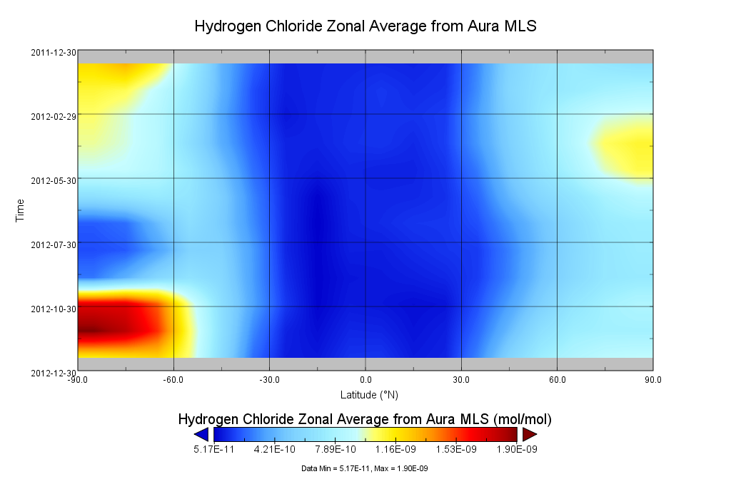
GOZCARDS Source Hydrogen Chloride 1 month L3 10 degree Zonal Means on a Vertical Pressure Grid V1 (GozSmlpHCl) at GES DISC
National Aeronautics and Space Administration —
The GOZCARDS Source Data for Hydrogen Chloride 1 month L3 10 degree Zonal Averages on a Vertical Pressure Grid product (GozSmlpHCl) contains zonal means and related... -
Federal
GPM GROUND VALIDATION KVNX NEXRAD MC3E V1
National Aeronautics and Space Administration —
The GPM Ground Validation KVNX NEXRAD MC3E dataset was collected from April 22, 2011 to June 6, 2011 for the Midlatitude Continental Convective Clouds Experiment... -
Federal
Bowen Ratio Surface Flux: UNL (FIFE)
National Aeronautics and Space Administration —
The Bowen Ratio Surface Flux Observations (UNL) Data Set contains surface flux and micrometeorolgical measurements collected at one location located in a flat area of... -
Federal
ARISE 2014 C-130 Remotely Sensed Aerosol and Trace Gas Data
National Aeronautics and Space Administration —
ARISE_Cloud_AircraftInSitu_C130_Data_1 is the Arctic Radiation - IceBridge Sea & Ice Experiment (ARISE) 2014 in-situ cloud data product. This product is a result... -
Federal
Arctic Vegetation Plots from Pingo Communities, North Slope, Alaska, 1984-1986
National Aeronautics and Space Administration —
This data set provides vegetation species and vegetation plot data collected between 1983 and 1985 from 293 study plots on 41 pingos on the North Slope of Alaska. The... -
Federal
Aquarius Official Release Level 3 Sea Surface Density Standard Mapped Image Monthly Data V5.0
National Aeronautics and Space Administration —
Aquarius Level 3 sea surface density standard mapped image data contains gridded 1 degree spatial resolution derived density averaged over daily, 7 day, monthly, and... -
Federal
Aquarius Official Release Level 3 Rain-flagged Sea Surface Salinity Standard Mapped Image Daily Data V5.0
National Aeronautics and Space Administration —
Aquarius Level 3 sea surface salinity (SSS) rain-flagged standard mapped image data contains gridded 1 degree spatial resolution SSS averaged overdaily, 7 day,... -
Federal
ECCO Atmosphere Surface Temperature, Humidity, Wind, and Pressure - Daily Mean llc90 Grid (Version 4 Release 4)
National Aeronautics and Space Administration —
This dataset provides daily-averaged atmosphere surface temperature, humidity, winds, and pressure on the native Lat-Lon-Cap 90 (LLC90) model grid from the ECCO... -
Federal
ABoVE: Dall Sheep Lamb Recruitment and Climate Data, Alaska and NW Canada, 2000-2015
National Aeronautics and Space Administration —
This dataset contains estimated annual average Dall sheep (Ovis dalli dalli) lamb-to-ewe ratios for each year from 2000-2015 across the full species range in Alaska... -
Federal
Gamma-RaySourceDetailedCatalog(Macomb&Gehrels1999)
National Aeronautics and Space Administration —
This database table contains the slightly revised contents of the detailed Tables 2A - 2G from the General Gamma-Ray Source Catalog of Macomb & Gehrels (1999). It... -
Federal
Aircraft Flux-Raw: U of Wy. (FIFE)
National Aeronautics and Space Administration —
The University of Wyoming (UW) King Air atmospheric boundary layer measurement missions were flown in 1987 during IFCs 3 and 4. This Raw Boundary Layer Fluxes data... -
Federal
Atacama Cosmology Telescope 2008 Survey 148-GHz Extragalactic Source Catalog
National Aeronautics and Space Administration —
This table contains a list of extragalactic radio sources detected in a 455 square-degree map of the southern sky made at a frequency of 148 GHz from the Atacama... -
Federal
KDIX NEXRAD IMPACTS V1
National Aeronautics and Space Administration —
The KDIX NEXRAD IMPACTS dataset consists of Next Generation Weather Radar (NEXRAD) Level II surveillance data that were collected at 31 NEXRAD sites from January 1 to... -
Federal
MMS 3 Electric Double Probe (EDP) Three-Dimensional Electric Field, Level 2 (L2), Slow Mode, 0.125 s Data
National Aeronautics and Space Administration —
Electric Double Probe, Quick-Look Three-Dimensional Electric Field, Level 2, Slow Survey Data -
Federal
AIRS/Aqua L3 8-day CO2 in the free troposphere (AIRS+AMSU) 2.5 degrees x 2 degrees V005 (AIRX3C28) at GES DISC
National Aeronautics and Space Administration —
Atmospheric Infrared Sounder (AIRS) is a grating spectrometer (R = 1200) aboard the second Earth Observing System (EOS) polar-orbiting platform, EOS Aqua. In...

Official websites use .gov
A
.gov website belongs to an official government
organization in the United States.
Secure .gov websites use HTTPS
A
lock (
) or https:// means you’ve safely connected to
the .gov website. Share sensitive information only on official,
secure websites.