
-
Federal
China Dimensions Data Collection: China County-Level Data from Provincial Economic Yearbooks, Keyed to 1:1M GIS Map
National Aeronautics and Space Administration —
The China County-Level Data on Provincial Economic Yearbooks, Keyed To 1:1M GIS Map consists of socioeconomic and boundary data for the administrative regions of... -
Federal
2008 Environmental Performance Index (EPI)
National Aeronautics and Space Administration —
The 2008 Environmental Performance Index (EPI) centers on two broad environmental protection objectives: (1) reducing environmental stresses on human health, and (2)... -
Federal
NASA Landsat Data Collection
National Aeronautics and Space Administration —
The NASA Landsat Data Collection (NLDC) is a compilation of Landsat multispectral scanner (MSS) scenes and Landsat thematic mapper (TM) scenes. This compilation of... -
Federal
Pilot 2006 Environmental Performance Index (EPI)
National Aeronautics and Space Administration —
The Pilot 2006 Environmental Performance Index (EPI) centers on two broad environmental protection objectives: (1) reducing environmental stresses on human health,... -
Federal
NPP Multi-Biome: Gridded Estimates for Selected Regions Worldwide, 1954-1998, R3
National Aeronautics and Space Administration —
This data set provides two data files (.csv format) containing gridded (0.5-degree) estimates of net primary productivity (NPP), elevation, temperature,... -
Federal
Water Quality (WQ) monitoring program for Clear Lake, CA
National Aeronautics and Space Administration —
Clear Lake is a large, shallow, hypereutrophic lake in Northern California, USA. Clear Lake is an important water resource for the surrounding community offering many... -
Federal
Natural Resource Protection and Child Health Indicators, 2020 Release
National Aeronautics and Space Administration —
The Natural Resource Protection and Child Health Indicators, 2020 Release, is produced in support of the U.S. Millennium Challenge Corporation as selection criteria... -
Federal
Natural Resource Protection and Child Health Indicators, 2014 Release
National Aeronautics and Space Administration —
The Natural Resource Protection and Child Health Indicators, 2014 Release, are produced in support of the U.S. Millennium Challenge Corporation as selection criteria... -
Federal
NARSTO EPA Supersite (SS) Houston, Texas Air Quality Study 2000 (TexAQS2000) Texas Natural Resource Conservation Commission (TNRCC) continuous ambient monitoring stations (CAMS) Air Quality Data
National Aeronautics and Space Administration —
NARSTO_EPA_HOUSTON_TEXAQS2000_CAMS_DATA is the North American Research Strategy for Tropospheric Ozone (NARSTO) Environmental Protection Agency (EPA) Supersite (SS)... -
Federal
Natural Resource Protection and Child Health Indicators, 2023 Release
National Aeronautics and Space Administration —
The Natural Resource Protection and Child Health Indicators, 2023 Release, is produced in support of the U.S. Millennium Challenge Corporation as selection criteria... -
Federal
Natural Resource Protection and Child Health Indicators, 2021 Release
National Aeronautics and Space Administration —
The Natural Resource Protection and Child Health Indicators, 2021 Release, is produced in support of the U.S. Millennium Challenge Corporation (MCC) as selection... -
Federal
Cryosolic pedons from Russia and Alaska, Version 1
National Aeronautics and Space Administration —
U.S. pedon data on the CAPS Version 1.0 CD-ROM, June 1998, are a sample of the pedon data contained on a CD-ROM produced by the National Soil Survey Center - Soil... -
Federal
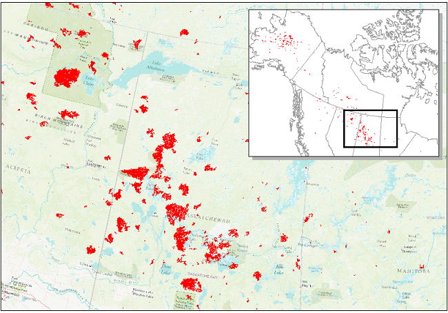
ABoVE: Landsat-derived Burn Scar dNBR across Alaska and Canada, 1985-2015
National Aeronautics and Space Administration —
This dataset contains differenced Normalized Burned Ratio (dNBR) at 30-m resolution calculated for burn scars from fires that occurred within the Arctic Boreal and... -
Federal
Natural Resource Protection and Child Health Indicators, 2022 Release
National Aeronautics and Space Administration —
The Natural Resource Protection and Child Health Indicators, 2022 Release, is produced in support of the U.S. Millennium Challenge Corporation (MCC) as selection... -
Federal
Natural Resource Protection and Child Health Indicators, 2013 Release
National Aeronautics and Space Administration —
The Natural Resource Protection and Child Health Indicators, 2013 Release, are produced in support of the U.S. Millennium Challenge Corporation as selection criteria... -
Federal
Global Soil Profile Data (ISRIC-WISE)
National Aeronautics and Space Administration —
The International Soil Reference and Information Centre-World Inventory of Soil Emission Potentials (ISRIC-WISE) international soil profile data set consists of a... -
Federal
ABoVE: Wildfire Date of Burning within Fire Scars across Alaska and Canada, 2001-2019
National Aeronautics and Space Administration —
This dataset provides estimates of wildfire progression represented by date of burning (DoB) within fire scars across Alaska and Canada for the period 2001-2019. Burn... -
Federal
Natural Resource Protection and Child Health Indicators, 2012 Release
National Aeronautics and Space Administration —
The Natural Resource Protection and Child Health Indicators, 2012 Release, are produced in support of the U.S. Millennium Challenge Corporation as selection criteria... -
Federal
Natural Resource Management Index (NRMI), 2010 Release
National Aeronautics and Space Administration —
The Natural Resource Management Index (NRMI), 2010 Release is a composite index for 157 countries derived from the average of four proximity-to-target indicators for... -
Federal
Natural Resource Protection and Child Health Indicators, 2017 Release
National Aeronautics and Space Administration —
The Natural Resource Protection and Child Health Indicators, 2017 Release, is produced in support of the U.S. Millennium Challenge Corporation (MCC) as selection...

Official websites use .gov
A
.gov website belongs to an official government
organization in the United States.
Secure .gov websites use HTTPS
A
lock (
) or https:// means you’ve safely connected to
the .gov website. Share sensitive information only on official,
secure websites.