

14 datasets found
-
Federal
BOREAS/SRC AMS Suite A Surface Meteorological and Radiation Data: 1996
National Aeronautics and Space Administration —
Contains the data collected in 1996 by the AMS suite A instrument set operated by SRC and provided to BORIS. -
Federal
BOREAS Scanning Lidar Imager of Canopies by Echo Recovery (SLICER): Level-3 Data
National Aeronautics and Space Administration —
Scanning Lidar Imager of Canopies by Echo Recovery (SLICER) data were acquired in support of BOReal Ecosystem-Atmosphere Study (BOREAS) at all of the Tower Flux (TF)... -
Federal
MAPSS: Mapped Atmosphere-Plant-Soil System Model, Version 1.0
National Aeronautics and Space Administration —
MAPSS (Mapped Atmosphere-Plant-Soil System) is a landscape to global vegetation distribution model that was developed to simulate the potential biosphere impacts and... -
Federal
BOREAS/SRC AMS Suite A Surface Meteorological and Radiation Data: 1994
National Aeronautics and Space Administration —
Contains the data collected in 1994 by the AMS suite A instrument set operated by SRC and provided to BORIS. -
Federal
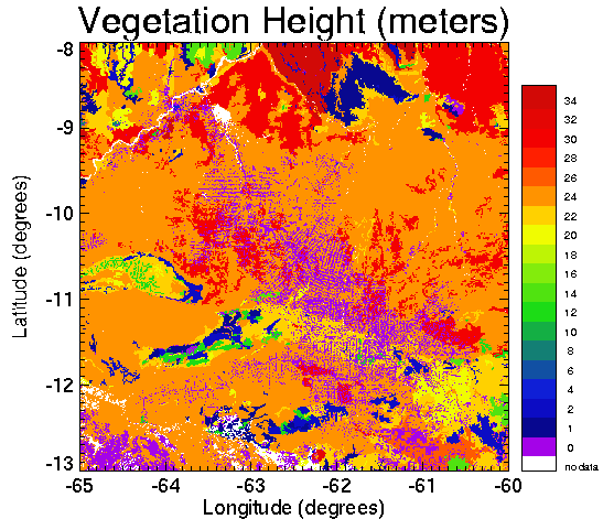
Pre-LBA CABARE Mapped Land Surface and Vegetation Characteristics, Rondonia, Brazil
National Aeronautics and Space Administration —
Surface parameter digital maps of vegetation, soil, and topography were obtained for Rondonia, Brazil, covering the 5x5 degree region bounded by 13-8 degrees S and... -
Federal
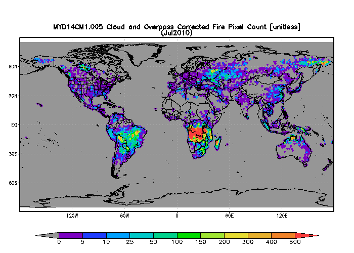
MODIS/Aqua 1 degree Gridded MODIS Active Fire Product V005 (MYD14CM1) at GES DISC NGDA
National Aeronautics and Space Administration —
The gridded MODIS active fire products present statistical summaries of fire pixel information (Giglio et al., 2003). The global monthly products are generated at 1x1... -
Federal
BOREAS HYD-03 Subcanopy Radiation Data
National Aeronautics and Space Administration —
This table contains the sub-canopy radiation data collected by HYD-3. -
Federal
RLC Forest Stand Carbon Map of Russia
National Aeronautics and Space Administration —
This dataset is a 1:15 million scale map of forest stand carbon for the land area of Russia (Stone et al., 2000). The objective was to create a first approximation of... -
Federal
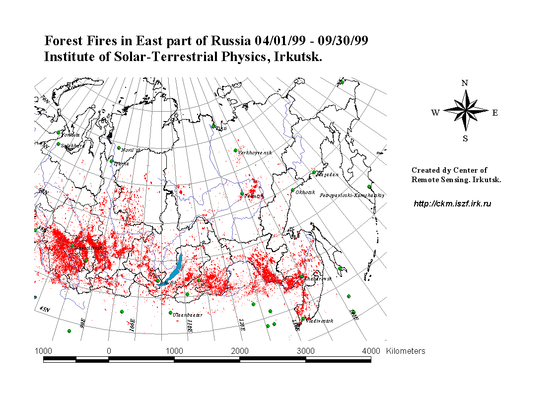
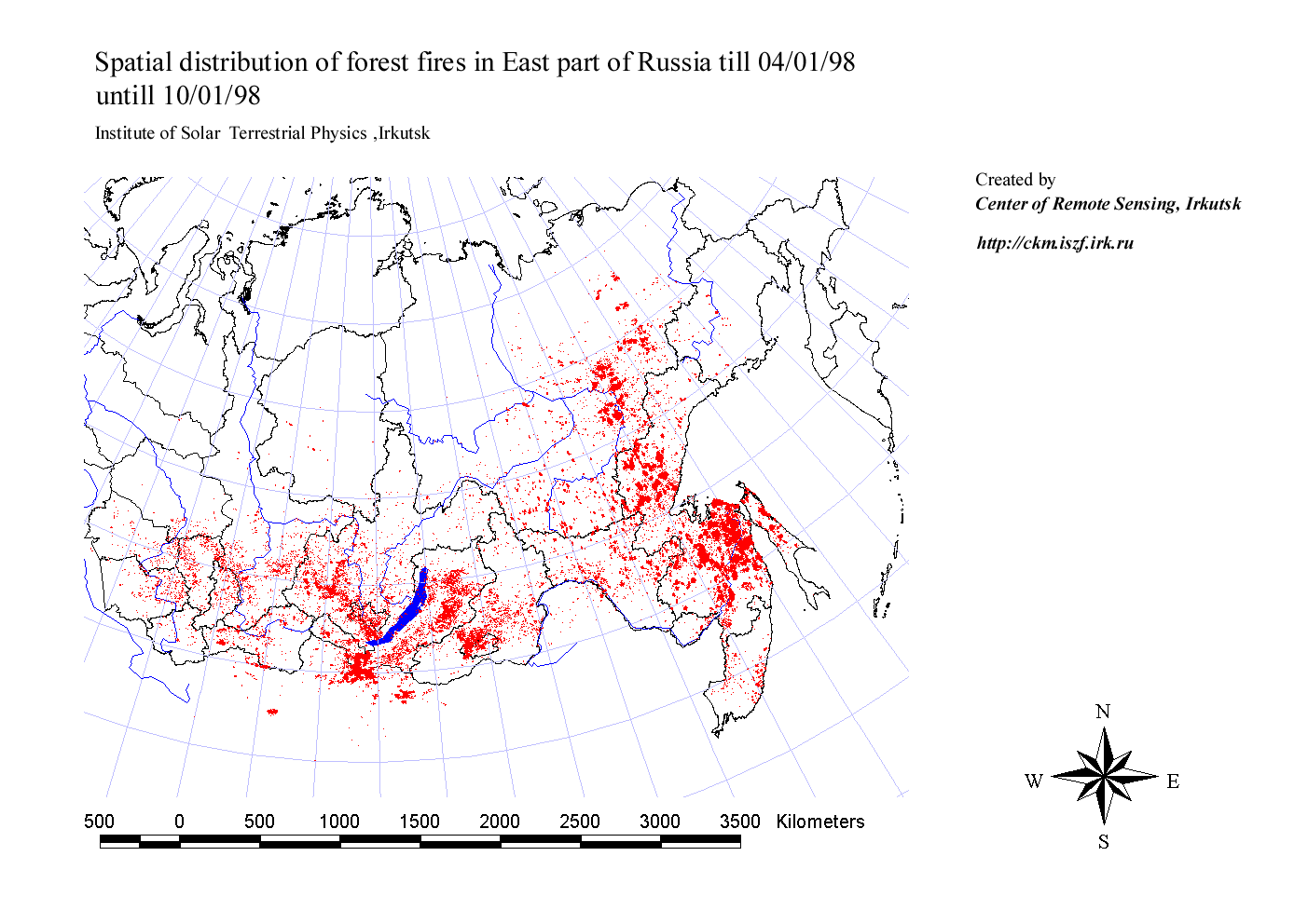
RLC Forest Fire Locations in Eastern Russia, 1998-1999
National Aeronautics and Space Administration —
This dataset is derived from Russian forest fire imagery from the National Forest Fire Center of Russia archive that was collected by the Center of Remote Sensing,... -
Federal
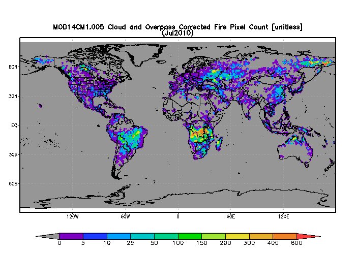
MODIS/Terra 1 degree Gridded MODIS Active Fire Product V005 (MOD14CM1) at GES DISC NGDA
National Aeronautics and Space Administration —
The gridded MODIS active fire products present statistical summaries of fire pixel information (Giglio et al., 2003). The global monthly products are generated at 1x1... -
Federal
ISLSCP II Global River Fluxes of Carbon and Sediments to the Oceans
National Aeronautics and Space Administration —
The River Carbon Flux data set represents estimates for the riverine export of carbon and of sediments. This data set includes the amounts of carbon and of sediments... -
Federal
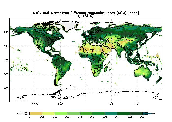
MODIS/Aqua Monthly Vegetation Indices Global 1x1 degree V005 (MYDVI) at GES DISC NGDA
National Aeronautics and Space Administration —
The global monthly gridded MODIS vegetation indices product is derived from the standard 0.05 CMG MODIS Aqua Vegetation Indices Monthly product MYD13C2 (Huete et al,... -
Federal
MODIS/Terra Monthly Vegetation Indices Global 1x1 degree V005 (MODVI) at GES DISC NGDA
National Aeronautics and Space Administration —
The global monthly gridded MODIS vegetation indices product is derived from the standard 0.05 CMG MODIS Terra Vegetation Indices Monthly product MOD13C2 (Huete et al,... -
Federal
BOREAS RSS-04 1994 Southern Study Area Jack Pine LAI & FPAR Data
National Aeronautics and Space Administration —
Contains Decagon Ceptometer estimates of LAI and fPAR. Contains LI-COR LAI-2000 estimates of leaf area index and mean tip angle.
14 datasets found