
-
Federal
Global Flood Hazard Frequency and Distribution
National Aeronautics and Space Administration —
The Global Flood Hazard Frequency and Distribution is a 2.5 minute grid derived from a global listing of extreme flood events between 1985 and 2003 (poor or missing... -
Federal
GPM Ground Validation Global Flood Monitoring System (GFMS) Flood Maps IFloodS V1
National Aeronautics and Space Administration —
The GPM Ground Validation Global Flood Monitoring System (GFMS) Flood Maps IFloodS dataset contains global flood estimates on a 0.25 degree spatial resolution every 3... -
Federal
Geocoded Disasters (GDIS) Dataset
National Aeronautics and Space Administration —
The Geocoded Disasters (GDIS) Dataset is a geocoded extension of a selection of natural disasters from the Centre for Research on the Epidemiology of Disasters'... -
Federal
Burn Scar - Corrected Reflectance (VIIRS / Suomi-NPP)
National Aeronautics and Space Administration —
This visualization represents a "false color" band combination (M11-I2-I1 | Red-Green-Blue) of data collected by the VIIRS instrument on the Suomi-NPP satellite and... -
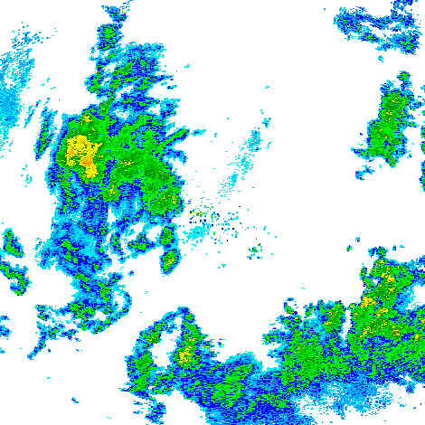
Federal
GPM GROUND VALIDATION NEXRAD LEVEL II KDVN IFLOODS V1
National Aeronautics and Space Administration —
The GPM Ground Validation Next Generation Weather Radar (NEXRAD) Level II IFloodS datasets were collected from four sites (see Table 1) from March 29, 2013 to June... -
Federal
Mirador - Earth Surface and Interior
National Aeronautics and Space Administration —
Earth Science data access made simple. The goal of the Earth Surface and Interior focus area is to assess, mitigate and forecast the natural hazards that affect... -
Federal
GPM GROUND VALIDATION MET ONE RAIN GAUGE PAIRS IFLOODS V2
National Aeronautics and Space Administration —
The GPM Ground Validation Met One Rain Gauge Pairs IFloodS V2 data measures the amount of fallen precipitation collected by a Model 380 tipping bucket rain gauge made... -
Federal
LBA-ECO LC-04 THMB Model Simulations for the Amazon and Tocantins Basins: 1939-1998
National Aeronautics and Space Administration —
The model output data provided were generated by the THMB 1.2 (Terrestrial Hydrology Model with Biogeochemistry) model which simulates the flow of water through... -
Federal
SMALL SOLAR SYSTEM OBJECTS SPECTROSCOPIC SURVEY V1.0
National Aeronautics and Space Administration —
This dataset contains the visible spectra of 820 asteroids obtained between November 1996 and May 2001 at the 1.52m telescope at ESO (La Silla). The useful spectral... -
Federal
Global Flood Proportional Economic Loss Risk Deciles
National Aeronautics and Space Administration —
The Global Flood Proportional Economic Loss Risk Deciles is a 2.5 minute grid of flood hazard economic loss as proportions of Gross Domestic Product (GDP) per... -
Federal
GPM Ground Validation Hydro-Estimator IFloodS V1
National Aeronautics and Space Administration —
The GPM Ground Validation Hydro-Estimator IFloodS dataset contains rainfall rate estimates derived using NOAA’s Geostationary Operational Environmental Satellites... -
Federal
GPM Ground Validation Goddard Profiling Algorithm (GPROF) 2014 IFloodS V3
National Aeronautics and Space Administration —
The GPM Ground Validation Goddard Profiling Algorithm (GPROF) 2014 IFloodS dataset consists of precipitation data derived from microwave radiometers and sounders... -
Federal
Groundswell Spatial Population and Migration Projections at One-Eighth Degree According to SSPs and RCPs, 2010-2050
National Aeronautics and Space Administration —
The Groundswell Spatial Population and Migration Projections at One-Eighth Degree According to SSPs and RCPs, 2010-2050, data set provides a baseline population... -
Federal
LBA-ECO LC-07 CO2 and CH4 Flux from Wetlands, Negro River Basin, Brazil: 2004-2006
National Aeronautics and Space Administration —
This data set provides estimates of daily and monthly carbon dioxide (CO2) and methane (CH4) diffusive and ebullitive flux for dry and flooded areas from two study... -
Federal
Global Multihazard Mortality Risks and Distribution
National Aeronautics and Space Administration —
The Global Multihazard Mortality Risks and Distribution is a 2.5 minute grid identifying and characterizing the nature of multihazard risk at the global scale. For... -
Federal
MODIS/Aqua+Terra Global Flood Product L3 NRT 250m 1-day GeoTIFF
National Aeronautics and Space Administration —
The MODIS/Aqua+Terra Global Flood Product L3 Near Real Time (NRT) 250m 1-day GeoTIFF (MCDWD_L3_F1_NRT) (beta) provides daily maps of flooding globally. The Global... -
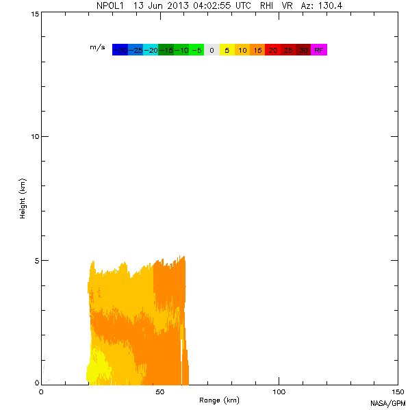
Federal
GPM GROUND VALIDATION NASA S-BAND DUAL POLARIMETRIC (NPOL) DOPPLER RADAR IFLOODS V2
National Aeronautics and Space Administration —
The GPM Ground Validation NASA S-Band Dual Polarimetric (NPOL) Doppler Radar IFloodS dataset was collected from April 30 to June 16, 2013 near Traer, Iowa as part of... -
Federal
GPM Ground Validation USGS Stream Flow IFloodS V1
National Aeronautics and Space Administration —
The GPM Ground Validation USGS Stream Flow IFloodS dataset was obtained from USGS during the Iowa Flood Studies (IFloodS) field campaign that extended from March 30,... -
Federal
Global Multihazard Total Economic Loss Risk Deciles
National Aeronautics and Space Administration —
The Global Multihazard Total Economic Loss Risk Deciles is a 2.5 minute grid of global multihazard total economic loss risks. First, for each of the considered... -
Federal
GPM Ground Validation NEXRAD Level III KDVN IFloodS
National Aeronautics and Space Administration —
The GPM Ground Validation NEXRAD Level III KDVN IFloodS dataset contain precipitation products derived from selected NEXt Generation Weather RADar system (NEXRAD)...

Official websites use .gov
A
.gov website belongs to an official government
organization in the United States.
Secure .gov websites use HTTPS
A
lock (
) or https:// means you’ve safely connected to
the .gov website. Share sensitive information only on official,
secure websites.