
-
Federal
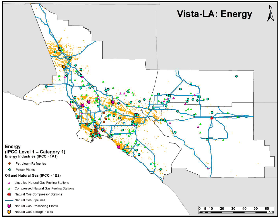
Sources of Methane Emissions (Vista-LA), South Coast Air Basin, California, USA recent views
National Aeronautics and Space Administration —
This data set provides spatial data products with identified and classified locations of potential methane (CH4) emitting facilities and infrastructure in the South... -
Federal
Methane Plumes Derived from AVIRIS-NG over Point Sources across California, 2016-2017 recent views
National Aeronautics and Space Administration —
This dataset provides maps of methane (CH4) plumes along flight lines over identified methane point-source emitting infrastructure across the State of California, USA... -
Federal
BOREAS AFM-06 Boundary Layer Height Data recent views
National Aeronautics and Space Administration —
Contains AFM-06 hourly inversion height measurements. -
Federal
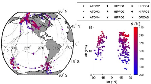
ATom: L2 Measurements from CU High-Resolution Aerosol Mass Spectrometer (HR-AMS) recent views
National Aeronautics and Space Administration —
This dataset provides the atmospheric concentrations of separated ions from inorganic and organic species measured by the High-Resolution Aerosol Mass Spectrometer... -
Federal
LBA-ECO ND-02 Agricultural and Secondary Forest Soil Trace Gas Flux, Para: 2001-2004 recent views
National Aeronautics and Space Administration —
This data set reports the results of a study to measure soil emissions of the carbon dioxide (CO2), methane (CH4), and nitrous oxide (N2O), and nitric oxide (NO)... -
Federal
Vulcan: High-Resolution Annual Fossil Fuel CO2 Emissions in USA, 2010-2015, Version 3 recent views
National Aeronautics and Space Administration —
The Vulcan version 3.0 annual dataset provides estimates of annual carbon dioxide (CO2) emissions from the combustion of fossil fuels (FF) and CO2 emissions from... -
Federal
ISLSCP II Globalview: Atmospheric CO2 Concentrations recent views
National Aeronautics and Space Administration —
The GlobalView Carbon Dioxide (CO2) data product contains synchronized and smoothed time series of atmospheric CO2 concentrations at selected sites that were created... -
Federal
ABoVE: Monthly Hydrological Fluxes for Canada and Alaska, 1979-2018 recent views
National Aeronautics and Space Administration —
This dataset provides modeled estimates of monthly hydrological fluxes at 0.25-degree resolution over Alaska and Canada for the years 1979-2018. The estimates were... -
Federal
Gridded Winter Soil CO2 Flux Estimates for pan-Arctic and Boreal Regions, 2003-2100 recent views
National Aeronautics and Space Administration —
This dataset provides gridded estimates of soil CO2 flux (g C m-2 d-1) for the winter non-growing season (NGS) across pan-Arctic and Boreal permafrost regions (>49... -
Federal
ATom: Age of Air, ArN2 Ratio, and Trace Gases in Stratospheric Samples, 2009-2018 recent views
National Aeronautics and Space Administration —
This dataset provides calculated age of air (AoA) and the argon/nitrogen (Ar/N2) ratio (per meg) from stratospheric flask samples and simultaneous high-frequency... -
Federal
LBA-ECO CD-01 Meteorological Data, Tapajos and Amazon Rivers, Santarem, Brazil: 2001 recent views
National Aeronautics and Space Administration —
This data set contains meteorological data collected around the confluence of the Tapajos River with the Amazon River in the Amazon Basin near Santarem, Brazil, in... -
Federal
VEMAP 2: U.S. Monthly Climate, 1895-1993, Version 2 recent views
National Aeronautics and Space Administration —
An integrated input data set for ecosystem and vegetation modeling for the conterminous United States. The data set is a ~100 year gridded monthly time series of... -
Federal
Simulated Fine Particulate Matter (PM2.5) Estimates over Alaska, 2001-2015 recent views
National Aeronautics and Space Administration —
The dataset provides simulated PM2.5 concentration estimates over Alaska, U.S. PM2.5 (particulate matter with diameter <= 2.5 microns) concentrations in air... -
Federal
VEMAP 2: Monthly Historical and Future Climate Data, Alaska, USA recent views
National Aeronautics and Space Administration —
This data set provides the results of the development of The Vegetation/Ecosystem Modeling and Analysis Project (VEMAP) Phase 2 transient climate change scenarios for... -
Federal
BOREAS ER2 Aircraft Flight Logs recent views
National Aeronautics and Space Administration —
During 1994 and 1996, digital and analog imaging instruments mounted on the NASA ER2 aircraft collected various remotely sensed data from the atmosphere and earth's... -
Federal
ABoVE: Wolf Denning Phenology and Reproductive Success, Alaska and Canada, 2000-2017 NGDA recent views
National Aeronautics and Space Administration —
This dataset provides annual gray wolf (Canis lupus) denning spatial information and timing, associated climatic and phenologic metrics, and reproductive success... -
Federal
CARVE: L2 Atmospheric CO2, CO, and CH4 Concentrations, CARVE Tower, Alaska, 2011-2015 recent views
National Aeronautics and Space Administration —
This data set provides atmospheric methane (CH4), carbon dioxide (CO2), and carbon monoxide (CO) dry air mole fractions and water vapor mole fractions (H2O) from... -
Federal
CARVE: L2 Column Gas and Uncertainty from Airborne FTS, Alaska, 2012-2015 recent views
National Aeronautics and Space Administration —
This data set provides total vertical column O2, CO2, CH4, CO, and H2O, as well as dry-air columns of CO2, CH4, CO, and H2O from airborne campaigns over the Alaskan... -
Federal
Global-Gridded Daily Methane Emissions from Inland Dam-Reservoir Systems recent views
National Aeronautics and Space Administration —
This dataset includes global maps of methane (CH4) emissions from inland dam-reservoir systems at 0.25-degree spatial resolution. Daily emission rates (as grams of... -
Federal
Burned and Unburned Field Site Data, Noatak, Seward, and North Slope, AK, 2016-2018 recent views
National Aeronautics and Space Administration —
This dataset includes field measurements from unburned and burned 10 m x 10 m and 1 m x 1 m plots in the Noatak, Seward, and North Slope regions of the Alaskan tundra...

Official websites use .gov
A
.gov website belongs to an official government
organization in the United States.
Secure .gov websites use HTTPS
A
lock (
) or https:// means you’ve safely connected to
the .gov website. Share sensitive information only on official,
secure websites.