
-
Federal
AIRSAR_TOPSAR_DEM
National Aeronautics and Space Administration —
AIRSAR topographic SAR digital elevation model product -
Federal
AIRSAR_TOPSAR_C-BAND_DEM_AND_STOKES
National Aeronautics and Space Administration —
AIRSAR topographic SAR digital elevation model C_Stokes product -
Federal
Gridded Population of the World, Version 4 (GPWv4): Data Quality Indicators, Revision 11
National Aeronautics and Space Administration —
The Gridded Population of the World, Version 4 (GPWv4): Data Quality Indicators, Revision 11 consists of three data layers created to provide context for the... -
Federal
Low Elevation Coastal Zone (LECZ) Global Delta Urban-Rural Population and Land Area Estimates, Version 1
National Aeronautics and Space Administration —
The Low Elevation Coastal Zone (LECZ) Global Delta Urban-Rural Population and Land Area Estimates, Version 1 data set provides country-level estimates of urban,... -
Federal
Alaska AVHRR Twice-Monthly Composites
National Aeronautics and Space Administration —
The goal of the Alaska Advanced Very High Resolution Radiometer (AVHRR) project is to compile a time series data set of calibrated, georegistered daily observations... -
Federal
AIRSAR_TOPSAR_DEM_C
National Aeronautics and Space Administration —
AIRSAR topographic SAR digital elevation model CTIF product -
Federal
Gridded Population of the World, Version 3 (GPWv3): National Administrative Boundaries
National Aeronautics and Space Administration —
The Gridded Population of the World, Version 3 (GPWv3): National Administrative Boundaries are derived from the land area grid to show the outlines of pixels (cells)... -
Federal
Gridded Population of the World, Version 3 (GPWv3): Centroids
National Aeronautics and Space Administration —
The Gridded Population of the World, Version 3 (GPWv3): Centroids consists of estimates of human population counts and densities for the years 1990, 1995, 2000, 2005,... -
Federal
Global Rural-Urban Mapping Project, Version 1 (GRUMPv1): Coastlines
National Aeronautics and Space Administration —
The Global Rural-Urban Mapping Project, Version 1 (GRUMPv1): Coastlines data are derived from the land area grids to show the outlines of pixels (cells) that contain... -
Federal
Sea Level Rise Impacts on Ramsar Wetlands of International Importance
National Aeronautics and Space Administration —
The Sea Level Rise Impacts on Ramsar Wetlands of International Importance data set represents the results of an analysis using the boundaries for Ramsar sites... -
Federal
AIRSAR_TOPSAR_DEM_P
National Aeronautics and Space Administration —
AIRSAR topographic SAR digital elevation model PTIF product -
Federal
AIRSAR_TOPSAR_DEM_L
National Aeronautics and Space Administration —
AIRSAR topographic SAR digital elevation model LTIF product -
Federal
Archive of Census Related Products (ACRP): 1990 Public Use Microdata Sample Areas (PUMA) Boundary Files
National Aeronautics and Space Administration —
The 1990 Public Use Microdata Sample Areas (PUMA) Boundary Files portion of the Archive of Census Related Products (ACRP) consists of 5% sample (apuma) and 1% sample... -
Federal
Gridded Population of the World, Version 3 (GPWv3): Coastlines
National Aeronautics and Space Administration —
The Gridded Population of the World, Version 3 (GPWv3): Coastlines are derived from the land area grid to show the outlines of pixels (cells) that contain... -
Federal
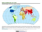
Gridded Population of the World, Version 4 (GPWv4): National Identifier Grid, Revision 11
National Aeronautics and Space Administration —
The Gridded Population of the World, Version 4 (GPWv4): National Identifier Grid, Revision 11 is a raster representation of nation-states in GPWv4 for use in... -
Federal
Nimbus-7 Narrow Field of View (NFOV) Maximum Likelihood Cloud Estimation (MLCE) Data in Native Format
National Aeronautics and Space Administration —
NIMBUS7_NFOV_MLCE data are Nimbus 7 Narrow Field of View (NFOV) Maximum Likelihood Cloud Estimation (MLCE) Data in Native Format.The NIMBUS7_NFOV_MLCE data set uses... -
Federal
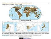
Gridded Population of the World, Version 4 (GPWv4): Administrative Unit Center Points with Population Estimates, Revision 11
National Aeronautics and Space Administration —
The Gridded Population of the World, Version 4 (GPWv4): Administrative Unit Center Points with Population Estimates, Revision 11 consists of UN WPP-adjusted...

Official websites use .gov
A
.gov website belongs to an official government
organization in the United States.
Secure .gov websites use HTTPS
A
lock (
) or https:// means you’ve safely connected to
the .gov website. Share sensitive information only on official,
secure websites.