
-
Federal
Global Pesticide Grids (PEST-CHEMGRIDS), Version 1.01
National Aeronautics and Space Administration —
The Global Pesticide Grids (PEST-CHEMGRIDS), Version 1.01 data set contains 20 of the most-used pesticide active ingredients on 6 dominant crops and 4 aggregated crop... -
Federal
HANPP Collection: Global Patterns in Net Primary Productivity (NPP)
National Aeronautics and Space Administration —
The HANPP Collection: Global Patterns in Net Primary Productivity (NPP) maps the net amount of solar energy converted to plant organic matter through photosynthesis.... -
Federal
TES/Aura L2 Carbonyl Sulfide Nadir V007
National Aeronautics and Space Administration —
TL2OCSN_7 is the Tropospheric Emission Spectrometer (TES)/Aura Level 2 Atmospheric Temperatures Limb Version 7 data product. TES was an instrument aboard NASA's Aura... -
Federal
Terra MODIS Global Mapped Particulate Organic Carbon (POC) - Near Real Time (NRT) Data, version R2022.0 NGDA
National Aeronautics and Space Administration —
The Ocean Biology DAAC produces near real-time (quicklook) products using the best-available combination of ancillary data from meteorological and ozone data. As... -
Federal
Suomi-NPP VIIRS Global Mapped Particulate Organic Carbon (POC) - Near Real Time (NRT) Data, version R2022.0
National Aeronautics and Space Administration —
The Ocean Biology DAAC produces near real-time (quicklook) products using the best-available combination of ancillary data from meteorological and ozone data. As... -
Federal
USGS Global Forest Observations Initiative (GFOI) Colombia
National Aeronautics and Space Administration —
The Global Forest Observations Initiative (GFOI) is an initiative of the inter-governmental Group on Earth Observations (GEO) that aims to: foster the sustained... -
Federal
NOAA-20 VIIRS Global Mapped Particulate Organic Carbon (POC) - Near Real Time (NRT) Data, version R2022.0
National Aeronautics and Space Administration —
The Ocean Biology DAAC produces near real-time (quicklook) products using the best-available combination of ancillary data from meteorological and ozone data. As... -
Federal
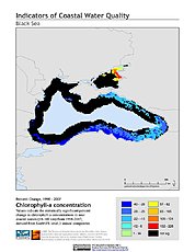
Indicators of Coastal Water Quality: Change in Chlorophyll-a Concentration 1998-2007
National Aeronautics and Space Administration —
The Change in Chlorophyll-a Concentrations 1998-2007 component of the Indicators of Coastal Water Quality Collection represents a tabular time series of the... -
Federal
Global Annual PM2.5 Grids from MODIS, MISR, SeaWiFS and VIIRS Aerosol Optical Depth (AOD), 1998-2022, V5.GL.04 NGDA
National Aeronautics and Space Administration —
The Global Annual PM2.5 Grids from MODIS, MISR, SeaWiFS and VIIRS Aerosol Optical Depth (AOD), 1998-2022, V5.GL.04 consists of annual concentrations (micrograms per... -
Federal
HANPP Collection: Human Appropriation of Net Primary Productivity as a Percentage of Net Primary Productivity
National Aeronautics and Space Administration —
The HANPP Collection: Human Appropriation of Net Primary Productivity as a Percentage of Net Primary Productivity represents a map identifying regions in which human... -
Federal
MetOp-A ASCAT Level 2 Ocean Surface Wind Vectors Optimized for Coastal Ocean
National Aeronautics and Space Administration —
This dataset contains operational near-real-time Level 2 coastal ocean surface wind vector retrievals from the Advanced Scatterometer (ASCAT) on MetOp-A at 12.5 km... -
Federal
Global Annual PM2.5 Grids from MODIS, MISR and SeaWiFS Aerosol Optical Depth (AOD), 1998-2019, V4.GL.03 NGDA
National Aeronautics and Space Administration —
The Global Annual PM2.5 Grids from MODIS, MISR and SeaWiFS Aerosol Optical Depth (AOD), 1998-2019, V4.GL.03 consists of annual concentrations (micrograms per cubic... -
Federal
Mission Reports IMPACTS V1
National Aeronautics and Space Administration —
The Mission Reports IMPACTS dataset consists of flight plans, plans of the day, science plans, and science summaries logged by scientists during the Investigation of... -
Federal
New York State Mesonet IMPACTS V1
National Aeronautics and Space Administration —
The New York State Mesonet IMPACTS dataset is a browse-only dataset and consists of temperature, wind, wind direction, mean sea level pressure, precipitation, and... -
Federal
Suomi-NPP VIIRS Global Binned Particulate Organic Carbon (POC) - Near Real Time (NRT) Data, version R2022.0
National Aeronautics and Space Administration —
The Ocean Biology DAAC produces near real-time (quicklook) products using the best-available combination of ancillary data from meteorological and ozone data. As... -
Federal
TES/Aura L2 Methanol Nadir V007
National Aeronautics and Space Administration —
TL2MTLN_7 is the Tropospheric Emission Spectrometer (TES)/Aura Level 2 Methanol Nadir Version 7 data product. TES was an instrument aboard NASA's Aura satellite and... -
Federal
TES/Aura L2 Methane Nadir V007
National Aeronautics and Space Administration —
TL2CH4N_7 is the Tropospheric Emission Spectrometer (TES)/Aura Level 2 Methane Nadir Version 7 data product. TES was an instrument aboard NASA's Aura satellite and... -
Federal
AVHRR 1-km Global Land 10-Day Composites
National Aeronautics and Space Administration —
The Advanced Very High Resolution Radiometer (AVHRR) 1-km Global Land 10-Day Composites data set project is a component of the National Aeronautics and Space... -
Federal
OrbView-2 SeaWiFS Global Binned Particulate Organic Carbon (POC) Data, version R2022.0
National Aeronautics and Space Administration —
The SeaWiFS instrument was launched by Orbital Sciences Corporation on the OrbView-2 (a.k.a. SeaStar) satellite in August 1997, and collected data from September 1997...

Official websites use .gov
A
.gov website belongs to an official government
organization in the United States.
Secure .gov websites use HTTPS
A
lock (
) or https:// means you’ve safely connected to
the .gov website. Share sensitive information only on official,
secure websites.