
-
Federal
Landsat 8
National Aeronautics and Space Administration —
The Operational Land Imager (OLI) and Thermal Infrared Sensor (TIRS) are onboard the Landsat 8 satellite, have acquired images of the Earth since February 2013. The... -
Federal
ASTER Global DEM NGDA
National Aeronautics and Space Administration —
ASTER is capable of collecting in-track stereo using nadir- and aft-looking near infrared cameras. Since 2001, these stereo pairs have been used to produce single-... -
Federal
EO-1 Hyperion
National Aeronautics and Space Administration —
The Earth-Observing One (EO-1) satellite was decommissioned March 2017. The EO-1 satellite was launched on November 21, 2000 with the NASA's New Millennium Program... -
Federal
AIRS/Aqua L2 Near Real Time (NRT) Cloud-Cleared Infrared Radiances (AIRS-only) V006 (AIRS2CCF_NRT) at GES DISC
National Aeronautics and Space Administration —
The Atmospheric Infrared Sounder (AIRS) Level 2 Near Real Time (NRT) Cloud-Cleared Infrared Radiances (AIRS-only) product (AIRS2CCF_NRT_006) differs from the routine... -
Federal
National Land Cover Data set 1992 (NLCD1992)
National Aeronautics and Space Administration —
National Land Cover Dataset 1992 (NLCD1992) is a 21-class land cover classification scheme that has been applied consistently across the lower 48 United States at a... -
Federal
FIREX-AQ Remotely Sensed Trace Gas Data
National Aeronautics and Space Administration —
FIREXAQ_TraceGas_AircraftRemoteSensing_DC8_Data are remotely sensed trace gas measurements conducted onboard the DC8 aircraft during FIREX-AQ. This product features... -
Federal
EO-1 (Earth Observing-1) Advanced Land Imager (ALI) Instrument Level 1R, Level 1Gs, Level 1Gst Data
National Aeronautics and Space Administration —
Advanced Land Imager (ALI) provides image data from ten spectral bands (band designations). The instrument operates in a pushbroom fashion, with a spatial resolution... -
Federal
CEOS Cal Val Test Site - Mauritania 1 - Pseudo-Invariant Calibration Site (PICS) NGDA
National Aeronautics and Space Administration —
On the background of these requirements for sensor calibration, intercalibration and product validation, the subgroup on Calibration and Validation of the Committee... -
Federal
OrbView-2 SeaWiFS 4B Global Binned Garver-Siegel-Maritorena Model (GSM) Data, version R2022.0
National Aeronautics and Space Administration —
The SeaWiFS instrument was launched by Orbital Sciences Corporation on the OrbView-2 (a.k.a. SeaStar) satellite in August 1997, and collected data from September 1997... -
Federal
AIRS/Aqua L1B Near Real Time (NRT) Infrared (IR) geolocated and calibrated radiances in BUFR format V005 (AIRIBRAD_NRT_BUFR) at GES DISC
National Aeronautics and Space Administration —
WARNING: On 2021/09/23 the EOS Aqua executed a Deep Space Maneuver (DSM). In the DSM, the spacecraft is turned such that the normal Earth field of regard is deep... -
Federal
Landsat Level-2 Surface Temperature Collection 2
National Aeronautics and Space Administration —
Landsat Level-2 Surface Temperature Collection 2 products contain atmospherically compensated surface temperature data derived from Level-1 thermal infrared data. It... -
Federal
AIRS/Aqua L2 Near Real Time (NRT) Support Retrieval (AIRS-only) V006 (AIRS2SUP_NRT) at GES DISC
National Aeronautics and Space Administration —
The Atmospheric Infrared Sounder (AIRS) Level 2 Near Real Time (NRT) Support Retrieval (AIRS-only) product (AIRS2SUP_NRT_006) differs from the routine product... -
Federal
ESMR/Nimbus-5 Images of Brightness Temperature on 70 mm Film V001 (ESMRN5IM) at GES DISC
National Aeronautics and Space Administration —
ESMRN5IM is the Nimbus-5 Electrically Scanning Microwave Radiometer (ESMR) data product containing daily brightness temperature images from 70-mm photofacsimile film... -
Federal
OrbView-2 SeaWiFS 4M Global Mapped Garver-Siegel-Maritorena Model (GSM) Data, version R2022.0
National Aeronautics and Space Administration —
The SeaWiFS instrument was launched by Orbital Sciences Corporation on the OrbView-2 (a.k.a. SeaStar) satellite in August 1997, and collected data from September 1997... -
Federal
Sentinel-5P TROPOMI Near-Real-Time (NRT) Carbon Monoxide CO Column 1-Orbit L2 5.5km x 7km V2 (S5P_L2__CO_____HiR_NRT) at GES DISC
National Aeronautics and Space Administration —
The Sentinel-5P TROPOMI Near Real Time (NRT) Carbon Monoxide CO Column 1-Orbit L2 5.5km x 7km V2 (S5P_L2__CO_HiR_NRT) at GES DISC is the near real time version of the... -
Federal
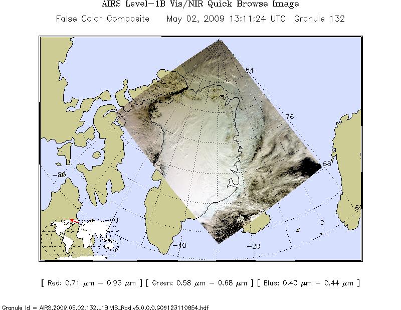
AIRS/Aqua L1B Near Real Time (NRT) Visible/Near Infrared (VIS/NIR) quality assurance subset V005 (AIRVBQAP_NRT) at GES DISC
National Aeronautics and Space Administration —
The AIRS Level 1B Near Real Time (NRT) product (AIRVBQAP_NRT_005) differs from the routine product (AIRVBQAP_005) in 2 ways to meet the three hour latency... -
Federal
OrbView-2 SeaWiFS Global Binned Inherent Optical Properties (IOP) Data, version R2022.0
National Aeronautics and Space Administration —
The SeaWiFS instrument was launched by Orbital Sciences Corporation on the OrbView-2 (a.k.a. SeaStar) satellite in August 1997, and collected data from September 1997... -
Federal
Sentinel-5P TROPOMI Near-Real-Time (NRT) Sulphur Dioxide SO2 1-Orbit L2 5.5km x 3.5km V2 (S5P_L2__SO2____HiR_NRT) at GES DISC
National Aeronautics and Space Administration —
The Sentinel-5P TROPOMI Near Real Time (NRT) Sulphur Dioxide SO2 1-Orbit L2 5.5km x 3.5km V2 (S5P_L2__SO2_HiRNRT) at GES DISC is the near real time version of the... -
Federal
AIRS/Aqua L1B Near Real Time (NRT) Visible/Near Infrared (VIS/NIR) geolocated and calibrated radiances V005 (AIRVBRAD_NRT) at GES DISC
National Aeronautics and Space Administration —
The AIRS Visible/Near Infrared (VIS/NIR) Level 1B Near Real Time (NRT) product (AIRVBRAD_NRT_005) differs from the routine product (AIRVBRAD_005) in 2 ways to meet...

Official websites use .gov
A
.gov website belongs to an official government
organization in the United States.
Secure .gov websites use HTTPS
A
lock (
) or https:// means you’ve safely connected to
the .gov website. Share sensitive information only on official,
secure websites.