
-
Federal
Declassified Satellite Imagery 2 (2002)
National Aeronautics and Space Administration —
Declassified satellite images provide an important worldwide record of land-surface change. With the success of the first release of classified satellite photography... -
Federal
CORONA Satellite Photographs from the U.S. Geological Survey
National Aeronautics and Space Administration —
The first generation of U.S. photo intelligence satellites collected more than 860,000 images of the Earth’s surface between 1960 and 1972. The classified military... -
Federal
MetOp-C ASCAT Level 2 25.0km Ocean Surface Wind Vectors in Full Orbit Swath
National Aeronautics and Space Administration —
This dataset contains operational near-real-time Level 2 ocean surface wind vector retrievals from the Advanced Scatterometer (ASCAT) on MetOp-C at 25 km sampling... -
Federal
China Dimensions Data Collection: China Maps Bibliographic Database
National Aeronautics and Space Administration —
The China Maps Bibliographic Database is an historical collection of bibliographic information for more than 400 maps of China. The information resides in a... -
Federal
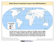
Global Volcano Proportional Economic Loss Risk Deciles
National Aeronautics and Space Administration —
Global Volcano Proportional Economic Loss Risk Deciles is a 2.5 minute grid of volcano hazard economic loss as proportions of Gross Domestic Product (GDP) per... -
Federal
NASA Landsat Data Collection
National Aeronautics and Space Administration —
The NASA Landsat Data Collection (NLDC) is a compilation of Landsat multispectral scanner (MSS) scenes and Landsat thematic mapper (TM) scenes. This compilation of... -
Federal
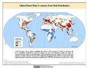
Global Flood Total Economic Loss Risk Deciles
National Aeronautics and Space Administration —
The Global Flood Total Economic Loss Risk Deciles is a 2.5 minute grid of global flood total economic loss risks. A process of spatially allocating Gross Domestic... -
Federal
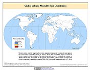
Global Volcano Mortality Risks and Distribution
National Aeronautics and Space Administration —
Global Volcano Mortality Risks and Distribution is a 2.5 minute grid representing global volcano mortality risks. The data set was constructed using historical... -
Federal
MetOp-B ASCAT Level 2 25.0km Ocean Surface Wind Vectors in Full Orbit Swath
National Aeronautics and Space Administration —
This dataset contains operational near-real-time Level 2 ocean surface wind vector retrievals from the Advanced Scatterometer (ASCAT) on MetOp-B at 25 km sampling... -
Federal
Global Drought Total Economic Loss Risk Deciles
National Aeronautics and Space Administration —
The Global Drought Total Economic Loss Risk Deciles is a 2.5 minute grid of global drought total economic loss risks. A process of spatially allocating Gross Domestic... -
Federal
Global Earthquake Proportional Economic Loss Risk Deciles
National Aeronautics and Space Administration —
The Global Earthquake Proportional Economic Loss Risk Deciles is a 2.5 minute grid of earthquake hazard economic loss as proportions of Gross Domestic Product (GDP)... -
Federal
Global Cyclone Proportional Economic Loss Risk Deciles
National Aeronautics and Space Administration —
The Global Cyclone Proportional Economic Loss Risk Deciles is a 2.5 minute grid of cyclone hazard economic loss as proportions of Gross Domestic Product (GDP) per... -
Federal
MetOp-A ASCAT Level 2 25.0 km Ocean Surface Wind Vectors
National Aeronautics and Space Administration —
This dataset contains operational near-real-time Level 2 ocean surface wind vector retrievals from the Advanced Scatterometer (ASCAT) on MetOp-A at 25 km sampling... -
Federal
High Mountain Asia Daily 5km Landslide Hazard Indicator V001
National Aeronautics and Space Administration —
This data set projects the daily hazard of rainfall-triggered landslides in the High Mountain Asia region from 2015 through 2100, at 5 km resolution. Projections are... -
Federal
Anthropogenic Biomes of the World, Version 2: 1700
National Aeronautics and Space Administration —
The Anthropogenic Biomes of the World, Version 2: 1700 data set describes anthropogenic transformations within the terrestrial biosphere caused by sustained direct... -
Federal
MetOp-A ASCAT Level 2 Ocean Surface Wind Vectors Optimized for Coastal Ocean
National Aeronautics and Space Administration —
This dataset contains operational near-real-time Level 2 coastal ocean surface wind vector retrievals from the Advanced Scatterometer (ASCAT) on MetOp-A at 12.5 km... -
Federal
Heat Capacity Mapping Mission (HCMM)
National Aeronautics and Space Administration —
The mission was the first of a series of NASA Applications Explorer Missions and is also known as AEM-A. Day/night coverage over a given area occurred at intervals...

Official websites use .gov
A
.gov website belongs to an official government
organization in the United States.
Secure .gov websites use HTTPS
A
lock (
) or https:// means you’ve safely connected to
the .gov website. Share sensitive information only on official,
secure websites.