
-
Federal
China Dimensions Data Collection: GuoBiao (GB) Codes for the Administrative Divisions of the Peoples Republic of China
National Aeronautics and Space Administration —
The GuoBiao (GB) Codes for the Administrative Divisions of the People's Republic of China consists of geographic codes for the administrative divisions of China. The... -
Federal
AIRSAR_TOPSAR_DEM
National Aeronautics and Space Administration —
AIRSAR topographic SAR digital elevation model product -
Federal
UAVSAR_POLSAR_METADATA
National Aeronautics and Space Administration —
UAVSAR PolSAR Scene Metadata -
Federal
AIRSAR_TOPSAR_C-BAND_DEM_AND_STOKES
National Aeronautics and Space Administration —
AIRSAR topographic SAR digital elevation model C_Stokes product -
Federal
OCO-2 Level 0 spacecraft attitude data V11 (OCO2_Att) at GES DISC
National Aeronautics and Space Administration —
Version 11 is the current version of the data set. Older versions will no longer be available and are superseded by Version 11. The Orbiting Carbon Observatory is the... -
Federal
UAVSAR_POLSAR_INCIDENCE
National Aeronautics and Space Administration —
UAVSAR PolSAR Scene Incidence Angle -
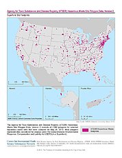
Federal
ATSDR Hazardous Waste Site Polygon Data, Version 2
National Aeronautics and Space Administration —
The Agency for Toxic Substances and Disease Registry (ATSDR) Hazardous Waste Site Polygon Data, Version 2 consists of 2,080 polygons for selected hazardous waste... -
Federal
UAVSAR_POLSAR_SLOPE
National Aeronautics and Space Administration —
UAVSAR PolSAR Scene Slope -
Federal
OCO-2 Level 0 spacecraft attitude data, Retrospective Processing V10r (OCO2_Att) at GES DISC
National Aeronautics and Space Administration —
Version 10r is the current version of the data set. Older versions will no longer be available and are superseded by Version 10r. Version 8r is the current version of... -
Federal
OCO-2 Level 0 spacecraft attitude data V10 (OCO2_Att) at GES DISC
National Aeronautics and Space Administration —
Version 10 is the current version of the data set. Older versions will no longer be available and are superseded by Version 10. The Orbiting Carbon Observatory is the... -
Federal
UAVSAR_POLSAR_ML_COMPLEX_GRD
National Aeronautics and Space Administration —
UAVSAR PolSAR Scene Projected -
Federal
OCO-2 Level 0 spacecraft ephemerides, Retrospective Processing V10r (OCO2_Eph) at GES DISC
National Aeronautics and Space Administration —
Version 10r is the current version of the data set. Older versions will no longer be available and are superseded by Version 10r. Version 8r is the current version of... -
Federal
OCO-2 Level 0 spacecraft attitude data, Retrospective Processing V11r (OCO2_Att) at GES DISC
National Aeronautics and Space Administration —
Version 11r is the current version of the data set. Older versions will no longer be available and are superseded by Version 11r. The Orbiting Carbon Observatory is... -
Federal
AIRSAR_TOPSAR_DEM_C
National Aeronautics and Space Administration —
AIRSAR topographic SAR digital elevation model CTIF product -
Federal
1:100,000-scale Digital Line Graphs (DLG) from the U.S. Geological Survey
National Aeronautics and Space Administration —
Digital line graph (DLG) data are digital representations of cartographic information. DLG's of map features are converted to digital form from maps and related... -
Federal
UAVSAR_INSAR_AMPLITUDE_GRD
National Aeronautics and Space Administration —
UAVSAR Repeat Pass Interferometry Ground Projected Amplitude Scene -
Federal
AIRSAR_POLSAR_3_FREQ_POLARIMETRY
National Aeronautics and Space Administration —
AIRSAR three-frequency polarimetric frame product -
Federal
UAVSAR_POLSAR_ML_COMPLEX_GRD_5X5
National Aeronautics and Space Administration —
UAVSAR PolSAR Scene Projected Multilook 5x5 -
Federal
AIRSAR_TOPSAR_L-BAND_STOKES
National Aeronautics and Space Administration —
AIRSAR topographic SAR digital elevation model L_Stokes product -
Federal
AIRSAR_TOPSAR_DEM_P
National Aeronautics and Space Administration —
AIRSAR topographic SAR digital elevation model PTIF product

Official websites use .gov
A
.gov website belongs to an official government
organization in the United States.
Secure .gov websites use HTTPS
A
lock (
) or https:// means you’ve safely connected to
the .gov website. Share sensitive information only on official,
secure websites.