

15 datasets found for "Contours"
-
Federal
Shuttle Radar Topography Mission (SRTM) Images recent views
National Aeronautics and Space Administration —
Culminating more than four years of processing data, NASA and the National Geospatial-Intelligence Agency (NGA) have completed Earth's most extensive global... -
Federal
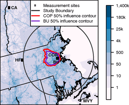
CO2 Observations, Modeled Emissions, and NAM-HYSPLIT Footprints, Boston MA, 2013-2014 recent views
National Aeronautics and Space Administration —
This dataset reports continuous atmospheric measurements of CO2 from two receptor sites and three boundary sites in and around Boston, Massachusetts, USA, that were... -
Federal
TRMM Ground Validation Radar Site 3D Rain Map L3 1 month 2 km V7 (TRMM_3A55) at GES DISC recent views
National Aeronautics and Space Administration —
The 3A55, 'Monthly 3-D Structure', provides radar site monthly 3-D structure information obtained from 2A55. The 2A55 'Radar Site 3-D Reflectivities', is composed of... -
Federal
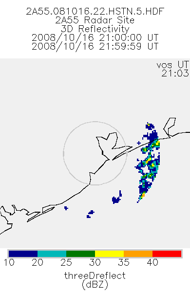
TRMM Ground Validation Radar Site 3D Reflectivity L2 1 hour V7 (TRMM_2A55) at GES DISC recent views
National Aeronautics and Space Administration —
'Radar Site 3-D Reflectivities', is composed of 3 different fields. The first field has an array of 3-D reflectivities in Cartesian coordinates with a 2 km horizontal... -
Federal
LBA-ECO LC-01 Topographic Data for Intensive Study Areas, Northern Ecuadorian Amazon recent views
National Aeronautics and Space Administration —
This data set contains topographic/geomorphological data associated with the four Intensive Study Areas (ISAs) in the Northern Ecuadorian Amazon (northern Oriente)... -
Federal
BOREAS HYD-08 DEM Data over the NSA-MSA and SSA-MSA in UTM Projection recent views
National Aeronautics and Space Administration —
DEMs produced from digitized contours at a cell resolution of 100 meters. -
Federal
China Dimensions Data Collection: Fundamental GIS: Digital Chart of China, 1:1M, Version 1 recent views
National Aeronautics and Space Administration —
The Fundamental GIS: Digital Chart of China, 1:1M, Version 1 consists of vector maps of China and surrounding areas. The maps include roads, railroads, drainage... -
Federal
Reduced-Resolution Radar Imagery, Digital Elevation Models, and Related GIS Layers for Barrow, Alaska, USA, Version 1 recent views
National Aeronautics and Space Administration —
This product set contains reduced-resolution Interferometric Synthetic Aperture Radar (IFSAR) imagery and geospatial data for the Barrow Peninsula (155.39 - 157.48... -
Federal
CLPX-Airborne: Infrared Orthophotography and Lidar Topographic Mapping, Version 1 recent views
National Aeronautics and Space Administration —
The data set consists of color infrared orthophotography (TerrainVision® - High resolution Topographic Mapping & Aerial Photography, with 6-inch pixel... -
Federal
CARVE: L4 Gridded Footprints from WRF-STILT model, 2012-2016 recent views
National Aeronautics and Space Administration —
This data set provides Weather Research and Forecasting (WRF) Stochastic Time-Inverted Lagrangian Transport (STILT) Footprint data products for particle receptors... -
Federal
Methane and Ethane Observations for Boston, MA, 2012-2020 recent views
National Aeronautics and Space Administration —
This dataset provides the hourly average of continuous atmospheric measurements of methane (CH4) from two urban sites and three boundary sites in and around Boston,... -
Federal
High-Resolution Radar Imagery, Digital Elevation Models, and Related GIS Layers for Barrow, Alaska, USA, Version 1 recent views
National Aeronautics and Space Administration —
This product set contains high-resolution Interferometric Synthetic Aperture Radar (IFSAR) imagery and geospatial data for the Barrow Peninsula (155.39 - 157.48 deg... -
Federal
Seasat and GEOSAT Altimetry for the Antarctic and Greenland Ice Sheets, Version 1 recent views
National Aeronautics and Space Administration —
Note: This data set is now on HTTPS so references to CD-ROM are historic and no longer applicable. The Ice Altimetry System (IAS) data seet contains surface... -
Federal
SCAMS/Nimbus-6 Images of Brightness Temperatures, Water Vapor and Temperature on 70-mm Film V001 (SCAMSN6IM) at GES DISC recent views
National Aeronautics and Space Administration —
The SCAMSN6IM data product consists of images of brightness temperatures, water vapor and temperature on 70 mm film strips from the Nimbus-6 Scanning Microwave... -
Federal
BOREAS Elevation Contours over the NSA and SSA ARC/Info Generate Format recent views
National Aeronautics and Space Administration —
Elevation contours over the NSA and SSA in ARC/Info Generate Format. Data cover portions of the BOREAS Northern Study Area (NSA) and Southern Study Area (SSA) and are...
15 datasets found for "Contours"