
-
Federal
Polar Ozone and Aerosol Measurement II Version 6
National Aeronautics and Space Administration —
POAM2_VER6 data are Polar Ozone and Aerosol Measurement II Version 6.0 data. The Polar Ozone and Aerosol Measurement (POAM) II instrument measures the vertical... -
Federal
Global Gridded Geographically Based Economic Data (G-Econ), Version 4
National Aeronautics and Space Administration —
The Global Gridded Geographically Based Economic Data (G-Econ), Version 4 contains derived one degree grid cells of Gross Domestic Product (GDP) data in Grid and... -
Federal
Georeferenced Population Datasets of Mexico (GEO-MEX): GIS of Mexican States, Municipalities and Islands
National Aeronautics and Space Administration —
The GIS of Mexican States, Municipalities and Islands consists of attribute and boundary data for 1990. The attribute data include population, language, education,... -
Federal
Global Roads Open Access Data Set, Version 1 (gROADSv1)
National Aeronautics and Space Administration —
The Global Roads Open Access Data Set, Version 1 (gROADSv1) was developed under the auspices of the CODATA Global Roads Data Development Task Group. The data set... -
Federal
U.S. Geological Survey Aerial Photography
National Aeronautics and Space Administration —
The U.S. Geological Survey (USGS) Aerial Photography data set includes over 2.5 million film transparencies. Beginning in 1937, photographs were acquired for mapping... -
Federal
HANPP Collection: Global Patterns in Net Primary Productivity (NPP)
National Aeronautics and Space Administration —
The HANPP Collection: Global Patterns in Net Primary Productivity (NPP) maps the net amount of solar energy converted to plant organic matter through photosynthesis.... -
Federal
Polar Ozone and Aerosol Measurement III
National Aeronautics and Space Administration —
POAM3 data are Polar Ozone and Aerosol Measurement III Version 3.0. The Polar Ozone and Aerosol Measurement (POAM) III instrument measures the vertical distribution... -
Federal
Global Population Density Grid Time Series Estimates
National Aeronautics and Space Administration —
The Global Population Density Grid Time Series Estimates provide a back-cast time series of population density grids based on the year 2000 population grid from... -
Federal
HANPP Collection: Human Appropriation of Net Primary Productivity as a Percentage of Net Primary Productivity
National Aeronautics and Space Administration —
The HANPP Collection: Human Appropriation of Net Primary Productivity as a Percentage of Net Primary Productivity represents a map identifying regions in which human... -
Federal
Global Volcano Hazard Frequency and Distribution
National Aeronautics and Space Administration —
Global Volcano Hazard Frequency and Distribution is a 2.5 minute gridded data set based upon the National Geophysical Data Center (NGDC) Volcano Database spanning the... -
Federal
Sentinel-5P TROPOMI Tropospheric NO2 1-Orbit L2 7km x 3.5km V1 (S5P_L2__NO2___) at GES DISC
National Aeronautics and Space Administration —
Starting from August 6th in 2019, Sentinel-5P TROPOMI along-track high spatial resolution (~5.5km at nadir) has been implemented. For data after August 6th of 2019,... -
Federal
Gridded Population of the World, Version 4 (GPWv4): Basic Demographic Characteristics, Revision 11
National Aeronautics and Space Administration —
The Gridded Population of the World, Version 4 (GPWv4): Basic Demographic Characteristics, Revision 11 consists of estimates of human population by age and sex as... -
Federal
HANPP Collection: Global Patterns in Human Appropriation of Net Primary Productivity (HANPP)
National Aeronautics and Space Administration —
The HANPP Collection: Global Patterns in Human Appropriation of Net Primary Productivity (HANPP) represents a digital map of human appropriation of net primary... -
Federal
Compendium of Environmental Sustainability Indicator Collections: The Wellbeing of Nations
National Aeronautics and Space Administration —
The Wellbeing of Nations portion of the Compendium of Environmental Sustainability Indicator Collections contains a subset of 123 variables assembled from the... -
Federal
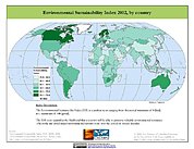
2002 Environmental Sustainability Index (ESI)
National Aeronautics and Space Administration —
The 2002 Environmental Sustainability Index (ESI) measures overall progress toward environmental sustainability for 142 countries based on environmental systems,... -
Federal
SWOT Level 2 Lake Single-Pass Vector Data Product, Version 2.0
National Aeronautics and Space Administration —
The SWOT Level 2 Lake Single-Pass Vector Data Product from the Surface Water Ocean Topography (SWOT) mission provides water surface elevation, area, storage change... -
Federal
2014 Environmental Performance Index (EPI)
National Aeronautics and Space Administration —
The 2014 Environmental Performance Index (EPI) ranks 178 countries on 20 performance indicators in the following 9 policy categories: health impacts, air quality,...

Official websites use .gov
A
.gov website belongs to an official government
organization in the United States.
Secure .gov websites use HTTPS
A
lock (
) or https:// means you’ve safely connected to
the .gov website. Share sensitive information only on official,
secure websites.