
-
Federal
NACP North American Forest Dynamics Project: Forest Disturbance and Regrowth Data recent views
National Aeronautics and Space Administration —
This data set provides the results of time-series analyses of Landsat imagery for 55 selected forested sites across the conterminous U.S.A. The output is a pair of... -
Federal
Decadal Land Use and Land Cover Classifications across India, 1985, 1995, 2005 recent views
National Aeronautics and Space Administration —
This data set provides land use and land cover (LULC) classification products at 100-m resolution for India at decadal intervals for 1985, 1995 and 2005. The data... -
Federal
NACP Integrated Wildland and Cropland 30-m Fuel Characteristics Map, U.S.A., 2010 recent views
National Aeronautics and Space Administration —
The data set provides a 30-m comprehensive fuelbed characteristics map for both the wildland and cropland areas of the conterminous United States (CONUS) for 2010.... -
Federal
Siberian Boreal Forest Aboveground Biomass and Fire Scar Maps, Russia, 1969-2007 NGDA recent views
National Aeronautics and Space Administration —
This data set provides 30-meter resolution mapped estimates of Cajander larch (Larix cajanderi) aboveground biomass (AGB), circa 2007, and a map of burn perimeters... -
Federal
Arctic Vegetation Plots at Toolik Lake, Alaska, 1989 recent views
National Aeronautics and Space Administration —
This dataset provides environmental, soil, and vegetation data collected in August 1989 from 81 study plots at the Toolik Lake research site, located in the southern... -
Federal
LUH2-ISIMIP2b Harmonized Global Land Use for the Years 2015-2100 recent views
National Aeronautics and Space Administration —
This dataset provides 0.25-degree gridded, global, annual estimates of fractional land use and land cover patterns for the period 2015-2100, designed to support the... -
Federal
AIRSAR_POLSAR_SYNOPTIC_3_FREQ_POLARIMETRY recent views
National Aeronautics and Space Administration —
AIRSAR three-frequency polarimetric synoptic product -
Federal
Land Use and Cover Maps from Landsat, Mawas, Central Kalimantan, Indonesia, 1994-2019 recent views
National Aeronautics and Space Administration —
This dataset contains annual land use/cover (LUC) maps at 30 m resolution across Mawas, Central Kalimantan, Indonesia. There are six files, each representing a five-... -
Federal
LUH1: Harmonized Global Land Use for Years 1500-2100, V1 recent views
National Aeronautics and Space Administration —
These data represent fractional land use and land cover patterns annually for the years 1500 - 2100 for the globe at 0.5-degree (~50-km) spatial resolution. Land use... -
Federal
Classification of Global Forests for IPCC Aboveground Biomass Tier 1 Estimates, 2020 recent views
National Aeronautics and Space Administration —
This dataset provides classes of global forests delineated by status/condition in 2020 at approximately 30-m resolution. The data support generating Tier 1 estimates... -
Federal
CEOS Cal Val Test Site - Ivanpah Playa, USA - Instrumented Site NGDA recent views
National Aeronautics and Space Administration —
On the background of these requirements for sensor calibration, intercalibration and product validation, the subgroup on Calibration and Validation of the Committee... -
Federal
MISR Level 2 Land Surface Product subset for the VBBE region V002 recent views
National Aeronautics and Space Administration —
Multi-angle Imaging SpectroRadiometer (MISR) is an instrument designed to view Earth with cameras pointed in 9 different directions. As the instrument flies overhead,... -
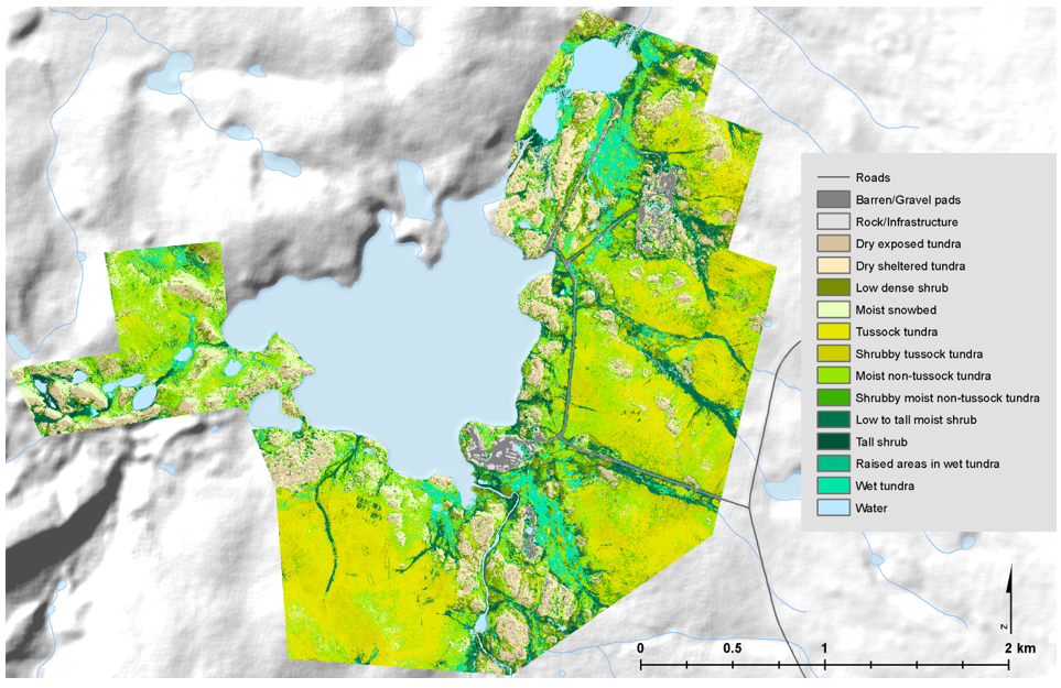
Federal
High-Resolution Vegetation Community Maps, Toolik Lake Area, Alaska, 2013-2015 recent views
National Aeronautics and Space Administration —
This dataset contains vegetation community maps at 20 cm resolution for three landscapes near the Toolik Lake research area in the northern foothills of the Brooks... -
Federal
LBA-ECO ND-30 Fractional Cover of Mixed Land Use Ranches, Para and Rondonia, Brazil recent views
National Aeronautics and Space Administration —
This data set contains images of fractional cover estimates of photosynthetic vegetation (PV) canopy, nonphotosynthetic vegetation (NPV), and exposed soils (S)... -
Federal
LBA-ECO ND-01 Fractional Land Cover Images, Rondonia, Brazil: 1984-2000 recent views
National Aeronautics and Space Administration —
This data set provides fractional land cover type images for shade, green vegetation (GV), non-photosynthetic vegetation (NPV), and soil for the regions of JiParana,... -
Federal
SMAPVEX12 PALS Soil Moisture Data V001 recent views
National Aeronautics and Space Administration —
This data set contains soil moisture data obtained by the Passive Active L-band System (PALS) aircraft instrument. The data were collected as part of SMAPVEX12, the... -
Federal
MISR Level 2 Land Surface Product subset for the GoMACCS region V002 recent views
National Aeronautics and Space Administration —
Multi-angle Imaging SpectroRadiometer (MISR) is an instrument designed to view Earth with cameras pointed in 9 different directions. As the instrument flies overhead,... -
Federal
AIRSAR_TOPSAR_C-BAND_DEM_AND_STOKES recent views
National Aeronautics and Space Administration —
AIRSAR topographic SAR digital elevation model C_Stokes product -
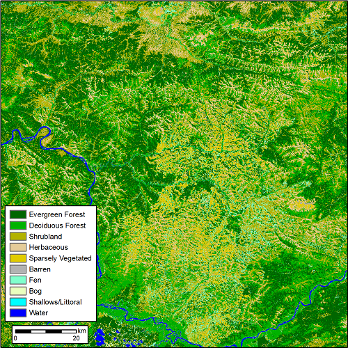
Federal
ABoVE: Landsat-derived Annual Dominant Land Cover Across ABoVE Core Domain, 1984-2014 recent views
National Aeronautics and Space Administration —
This dataset provides two 30-m resolution time series products of annual land cover classifications over the Arctic Boreal Vulnerability Experiment (ABoVE) core... -
Federal
Last of the Wild Project, Version 2, 2005 (LWP-2): Global Human Footprint Dataset (IGHP) recent views
National Aeronautics and Space Administration —
The Global Human Footprint Dataset of the Last of the Wild Project, Version 2, 2005 (LWP-2) is the Human Influence Index (HII) normalized by biome. The HII is a...

Official websites use .gov
A
.gov website belongs to an official government
organization in the United States.
Secure .gov websites use HTTPS
A
lock (
) or https:// means you’ve safely connected to
the .gov website. Share sensitive information only on official,
secure websites.