ABoVE: Landsat-derived Annual Dominant Land Cover Across ABoVE Core Domain, 1984-2014
Access & Use Information
Downloads & Resources
-
Google Scholar search resultsHTML
Search results for publications that cite this dataset by its DOI.
-
Download this datasetHTML
This link allows direct data access via Earthdata login
-
View documentation related to this datasetHTML
ORNL DAAC Data Set Documentation
-
This dataset's landing pageHTML
Data set Landing Page DOI URL
-
View documentation related to this datasetPDF
ABoVE: Landsat-derived Annual Dominant Land Cover Across ABoVE Core Domain,...
-
Get a related visualizationPNG
Land cover (10-class product) for the year 1984 in the ABoVE domain for...
-
The dataset's project home pageHTML
ABoVE project site
-
Landing PageLanding Page
Dates
| Metadata Created Date | December 1, 2022 |
|---|---|
| Metadata Updated Date | December 6, 2023 |
Metadata Source
- Data.json Data.json Metadata
Harvested from NASA Data.json
Graphic Preview

Additional Metadata
| Resource Type | Dataset |
|---|---|
| Metadata Created Date | December 1, 2022 |
| Metadata Updated Date | December 6, 2023 |
| Publisher | ORNL_DAAC |
| Maintainer | |
| Identifier | C2143403402-ORNL_CLOUD |
| Data First Published | 2020-11-09 |
| Language | en-US |
| Data Last Modified | 2023-06-12 |
| Category | ABoVE, geospatial |
| Public Access Level | public |
| Bureau Code | 026:00 |
| Metadata Context | https://project-open-data.cio.gov/v1.1/schema/catalog.jsonld |
| Metadata Catalog ID | https://data.nasa.gov/data.json |
| Schema Version | https://project-open-data.cio.gov/v1.1/schema |
| Catalog Describedby | https://project-open-data.cio.gov/v1.1/schema/catalog.json |
| Citation | Wang, J.A., D. Sulla-Menashe, C.E. Woodcock, O. Sonnentag, R.F. Keeling, and M.A. Friedl. 2019. ABoVE: Landsat-derived Annual Dominant Land Cover Across ABoVE Core Domain, 1984-2014. ORNL DAAC, Oak Ridge, Tennessee, USA. https://doi.org/10.3334/ORNLDAAC/1691 |
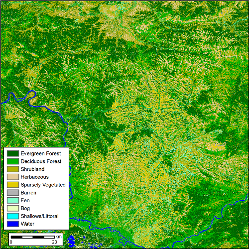
| Graphic Preview Description | Land cover (10-class product) for the year 1984 in the ABoVE domain for analysis tile BH03V04. The pixel resolution is 30 m and a tile is 180 x 180 km. Refer to Figure 3 for the landcover in the same tile for the year 2014. (from ABoVE_LandCover_BH03V04.tif) |
| Graphic Preview File | https://daac.ornl.gov/ABOVE/guides/Annual_Landcover_ABoVE_Fig1.png |
| Harvest Object Id | c10533ea-fa00-420e-8d1e-f92f7aac2309 |
| Harvest Source Id | 58f92550-7a01-4f00-b1b2-8dc953bd598f |
| Harvest Source Title | NASA Data.json |
| Homepage URL | https://doi.org/10.3334/ORNLDAAC/1691 |
| Metadata Type | geospatial |
| Old Spatial | -170.01 50.26 -98.97 76.23 |
| Program Code | 026:001 |
| Source Datajson Identifier | True |
| Source Hash | 02bdd63d5c03e747f3a6b0642fc23753ff3bc51baec212eda377c829da4bcec0 |
| Source Schema Version | 1.1 |
| Spatial | |
| Temporal | 1984-01-01T00:00:00Z/2014-12-31T23:59:59Z |
Didn't find what you're looking for? Suggest a dataset here.

