
-
Federal
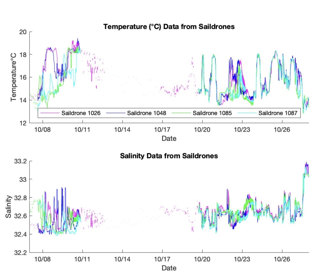
S-MODE L2 Temperature and Salinity from Saildrones Version 1 recent views
National Aeronautics and Space Administration —
This dataset contains Saildrone in-situ measurements taken during the Sub-Mesoscale Ocean Dynamics Experiment (S-MODE) conducted approximately 300 km offshore of San... -
Federal
ECCO Ocean Temperature and Salinity - Daily Mean 0.5 Degree (Version 4 Release 4) recent views
National Aeronautics and Space Administration —
This dataset contains daily-averaged ocean potential temperature and salinity interpolated to a regular 0.5-degree grid from the ECCO Version 4 revision 4 (V4r4)... -
Federal
GHRSST Level 2P Western Atlantic Regional Skin Sea Surface Temperature from the Geostationary Operational Environmental Satellites (GOES) Imager on the GOES-13 satellite (GDS version 2) recent views
National Aeronautics and Space Administration —
The Geostationary Operational Environmental Satellites (GOES) operated by the United States National Oceanic and Atmospheric Administration (NOAA) support weather... -
Federal
Ecomapper data for the SPURS-1 N. Atlantic field campaign recent views
National Aeronautics and Space Administration —
The SPURS (Salinity Processes in the Upper Ocean Regional Study) project is an oceanographic process study and associated field program that aim to elucidate key... -
Federal
Northwest Pacific Pre-SWOT Level-4 Hourly MITgcm LLC4320 Native Grid 2km Oceanographic Dataset Version 1.0 recent views
National Aeronautics and Space Administration —
This dataset provides a regional multivariate oceanographic state estimate from a global ocean numerical simulation with a focus on the Northwest Pacific Ocean... -
Federal
MODIS Aqua Level 3 SST MID-IR Daily 4km Nighttime V2019.0 NGDA recent views
National Aeronautics and Space Administration —
Day and night spatially gridded (L3) global NASA skin sea surface temperature (SST) products from the Moderate-resolution Imaging Spectroradiometer (MODIS) onboard... -
Federal
MODIS Aqua Level 3 SST MID-IR Monthly 4km Nighttime V2019.0 NGDA recent views
National Aeronautics and Space Administration —
Day and night spatially gridded (L3) global NASA skin sea surface temperature (SST) products from the Moderate-resolution Imaging Spectroradiometer (MODIS) onboard... -
Federal
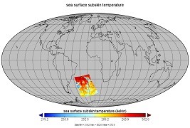
GHRSST Level 2P Global Subskin Sea Surface Temperature from the Advanced Scanning Microwave Radiometer - Earth Observing System (AMSR-E) on the NASA Aqua Satellite recent views
National Aeronautics and Space Administration —
The Advanced Microwave Scanning Radiometer (AMSR-E) was launched on 4 May 2002, aboard NASA's Aqua spacecraft. The National Space Development Agency of Japan (NASDA)... -
Federal
MODIS Aqua Level 3 SST Thermal IR Annual 4km Nighttime V2019.0 NGDA recent views
National Aeronautics and Space Administration —
Day and night spatially gridded (L3) global NASA skin sea surface temperature (SST) products from the Moderate-resolution Imaging Spectroradiometer (MODIS) onboard... -
Federal
MODIS Aqua Level 3 SST Thermal IR 8 Day 4km Daytime V2019.0 NGDA recent views
National Aeronautics and Space Administration —
Day and night spatially gridded (L3) global NASA skin sea surface temperature (SST) products from the Moderate-resolution Imaging Spectroradiometer (MODIS) onboard... -
Federal
MODIS Terra Level 3 SST Thermal IR Monthly 9km Daytime V2019.0 NGDA recent views
National Aeronautics and Space Administration —
Day and night spatially gridded global NASA skin sea surface temperature (SST) products from the Moderate-resolution Imaging Spectroradiometer (MODIS) onboard the... -
Federal
MODIS Terra Level 3 SST Thermal IR Annual 9km Daytime V2019.0 NGDA recent views
National Aeronautics and Space Administration —
TDay and night spatially gridded (L3) global NASA skin sea surface temperature (SST) products from the Moderate-resolution Imaging Spectroradiometer (MODIS) onboard... -
Federal
MODIS Terra Level 3 SST Thermal IR Monthly 4km Nighttime V2019.0 NGDA recent views
National Aeronautics and Space Administration —
Day and night spatially gridded global NASA skin sea surface temperature (SST) products from the Moderate-resolution Imaging Spectroradiometer (MODIS) onboard the... -
Federal
Saildrone field campaign surface and ADCP measurements for the Atlantic Tradewind Ocean-Atmosphere Mesoscale Interaction Campaign (ATOMIC) project recent views
National Aeronautics and Space Administration —
Saildrone is a wind and solar powered unmanned surface vehicle (USV) capable of long distance deployments lasting up to 12 months and providing high quality, near... -
Federal
GHRSST Level 2P NOAA STAR SST v2.80 from VIIRS on S-NPP Satellite recent views
National Aeronautics and Space Administration —
The Joint Polar Satellite System (JPSS), starting with S-NPP launched on 28 October 2011, is the new generation of the US Polar Operational Environmental Satellites... -
Federal
Waveglider data for the SPURS-1 N. Atlantic field campaign recent views
National Aeronautics and Space Administration —
The SPURS (Salinity Processes in the Upper Ocean Regional Study) project is an oceanographic process study and associated field program that aim to elucidate key... -
Federal
Black Sea High Resolution SST L4 Analysis 0.0625 deg Resolution NGDA recent views
National Aeronautics and Space Administration —
CNR MED Sea Surface Temperature provides daily gap-free maps (L4) at 0.0625 deg. x 0.0625 deg. horizontal resolution over the Black Sea. The data are obtained from... -
Federal
GHRSST L2P NOAA/ACSPO GOES-18/ABI America Region Sea Surface Temperature v2.90 dataset recent views
National Aeronautics and Space Administration —
The G18-ABI-L2P-ACSPO-v2.90 dataset produced by the NOAA Advanced Clear Sky Processor for Ocean (ACSPO) system is used to derive Sea Surface Skin Temperature (SST)... -
Federal
SPURS-2 S/V Lady Amber underway Thermosalinograph and Sea Snake data for the E. Tropical Pacific field campaign recent views
National Aeronautics and Space Administration —
The SPURS (Salinity Processes in the Upper Ocean Regional Study) project is a NASA-funded oceanographic process study and associated field program that aim to... -
Federal
CYGNSS Level 2 Ocean Surface Heat Flux Climate Data Record Version 1.2 recent views
National Aeronautics and Space Administration —
This dataset contains the Version 1.2 CYGNSS Level 2 Ocean Surface Heat Flux Climate Data Record, which provides time-tagged and geolocated ocean surface heat flux...

Official websites use .gov
A
.gov website belongs to an official government
organization in the United States.
Secure .gov websites use HTTPS
A
lock (
) or https:// means you’ve safely connected to
the .gov website. Share sensitive information only on official,
secure websites.