
-
Federal
Supercritical Airfoil Coordinates recent views
National Aeronautics and Space Administration —
Rectangular Supercritical Wing (Ricketts) - design and measured locations are provided in an Excel file RSW_airfoil_coordinates_ricketts.xls . One sheet is with Non... -
Federal
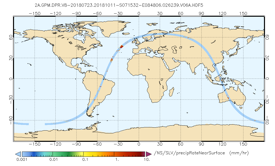
GPM DPR Precipitation Profile L2A 1.5 hours 5 km V07 (GPM_2ADPR) at GES DISC recent views
National Aeronautics and Space Administration —
Version 07 is the current version of the data set. Older versions will no longer be available and have been superseded by Version 07. . 2ADPR provides single- and... -
Federal
DXC'10 Results recent views
National Aeronautics and Space Administration —
Results for the DXC'10 Industrial Track. -
Federal
Agency IP Data recent views
National Aeronautics and Space Administration —
Public data set for NASA Agency Intellectual Property (IP). The distribution contains both Patent information as well as General Release of Open Source Software. -
Federal
Agency IP Data recent views
National Aeronautics and Space Administration —
Public data set for NASA Agency Intellectual Property (IP). The distribution contains both Patent information as well as General Release of Open Source Software. -
Federal
HIRENASD Beam FEM recent views
National Aeronautics and Space Administration —
This contains attempts to create BEAM FEM model. I have started a Blog to discuss this... please put your comments there and I will attempt to keep everything... -
Federal
DXC'09 Results recent views
National Aeronautics and Space Administration —
Results for DXC'09 -
Federal
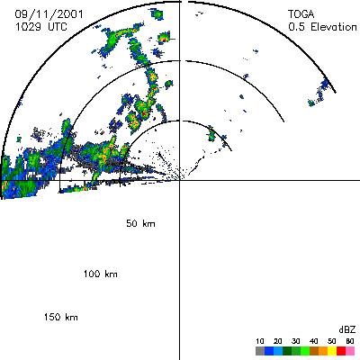
CAMEX-4 TOGA RADAR V1 recent views
National Aeronautics and Space Administration —
The TOGA radar dataset consists of browse and radar data collected from the TOGA radar during the CAMEX-4 experiment. TOGA is a C-band linear polarized doppler radar... -
Federal
SAFARI 2000 ER-2 Color-IR Aerial Photography, Dry Season 2000 recent views
National Aeronautics and Space Administration —
Aerial photography from the NASA ER-2 high-altitude aircraft was collected to provide detailed and spatially extensive documentation over parts of the SAFARI study... -
Federal
SAFARI 2000 Fire Emission Data, Dry Season 2000 recent views
National Aeronautics and Space Administration —
As part of the SAFARI 2000), the University of Montana participated in both ground-based and airborne campaigns during the southern African dry season of 2000 to... -
Federal
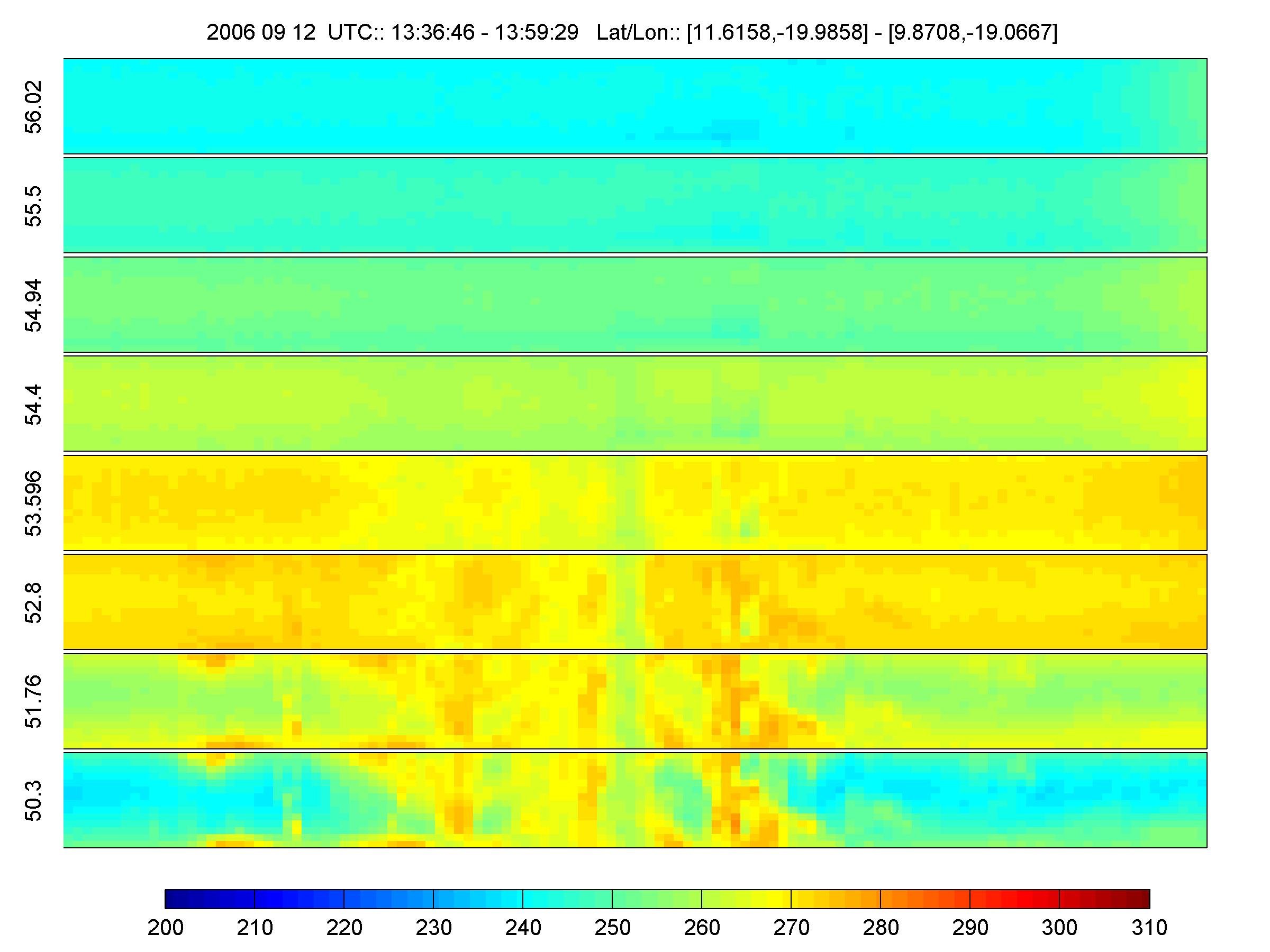
NAMMA HIGH ALTITUDE MMIC SOUNDING RADIOMETER (HAMSR) V1 recent views
National Aeronautics and Space Administration —
The NAMMA High Altitude MMIC Sounding Radiometer (HAMSR) dataset consists of data collected by HAMSR, which is a 25-channel microwave atmospheric sounder operating as... -
Federal
Integrated Health Management Definitions recent views
National Aeronautics and Space Administration —
The Joint Army Navy NASA Air Force Modeling and Simulation Subcommittee's Integrated Health Management panel was started about 6 years ago to help foster... -
Federal
SAFARI 2000 Landscape Photographs of Kalahari Transect, Mongu, Skukuza Sites recent views
National Aeronautics and Space Administration —
This data set contains Global Positioning System (GPS) imprinted landscape photographs at 100-m intervals along the Large Grid Transects at Kalahari Transect sites in... -
Federal
GPM Ground Validation NASA EPFL-LTE Parsivel DSD Data Lausanne, Switzerland V1 recent views
National Aeronautics and Space Administration —
The GPM Ground Validation NASA EPFL-LTE Parsivel DSD Data Lausanne, Switzerland dataset consists of a network of 16 Parsivel disdrometers deployed on the Ecole... -
Federal
Global Distribution of Root Turnover in Terrestrial Ecosystems recent views
National Aeronautics and Space Administration —
Estimates of root turnover rates were calculated from measurements of live root standing crop and belowground net primary production (BNPP) compiled from the primary... -
Federal
BOREAS Landsat TM Level-3s Imagery: Scaled At-Sensor Radiance in LGSOWG Format recent views
National Aeronautics and Space Administration —
For BOREAS, the level-3s Landsat TM data, along with the other remotely sensed images, were collected in order to provide spatially extensive information over the... -
Federal
Agency Data on User Facilities recent views
National Aeronautics and Space Administration —
The purpose of the Aerospace Technical Facility Inventory is to facilitate the sharing of specialized capabilities within the aerospace research/engineering community...

Official websites use .gov
A
.gov website belongs to an official government
organization in the United States.
Secure .gov websites use HTTPS
A
lock (
) or https:// means you’ve safely connected to
the .gov website. Share sensitive information only on official,
secure websites.