
Search datasets
-
Maryland Priority Funding Areas Priority Funding Areas are existing communities and places where local governments want State investment to support future growth. The 1997 Priority Funding Areas...
Search relevance: 1.00 | Views last month: 20 | Catalog Last Checked: May 14, 2026 at 11:57 PM -
This package contains USGS data contributions to the DOE-funded Nevada Geothermal Machine Learning Project, with the objective of developing a machine learning approach to identifying new...
Search relevance: 1.00 | Views last month: 4 | Catalog Last Checked: March 23, 2026 at 09:41 PM -
Provided here is a link to the National Park Service boundaries for the state of Hawaii. Maps are provided as an interactive web viewer as well as PDF doucments.
Search relevance: 1.00 | Views last month: 4 | Catalog Last Checked: May 07, 2026 at 08:26 PM -
The Mountain Home area is characterized by high heat flow and temperature gradient. Temperature data are available from 18 boreholes with depths equal to or greater than 200 m, 5 of which have...
Search relevance: 1.00 | Views last month: 3 | Catalog Last Checked: March 23, 2026 at 09:40 PM -
This dataset compiles groundwater recharge data for the Island of Hawaii derived from published studies, including work by Whittier and El-Kadi (2014) and Oki (1999, 2002), which are all linked...
Search relevance: 1.00 | Views last month: 2 | Catalog Last Checked: May 28, 2026 at 04:41 PM -
Git archive containing Python modules and resources used to generate machine-learning models used in the "Applications of Machine Learning Techniques to Geothermal Play Fairway Analysis in the...
Search relevance: 1.00 | Views last month: 1 | Catalog Last Checked: March 23, 2026 at 09:41 PM -
This dataset includes magnetotelluric transfer functions in the form of EDI files for 16 stations collected by the USGS and 40 stations collected by Quantec Geoscience for Lawerence Berkeley...
Search relevance: 1.00 | Views last month: 1 | Catalog Last Checked: March 23, 2026 at 09:41 PM -
This dataset compiles groundwater recharge data for the islands of Kauai, Lanai and Molokai derived from published studies. The dataset is provided as a geospatial shapefiles with associated...
Search relevance: 1.00 | Views last month: 1 | Catalog Last Checked: April 17, 2026 at 06:04 AM -
This dataset contain raw data files in kmz files (Google Earth georeference format). These files include volcanic vent locations and age, the distribution of fine-grained lacustrine sediments...
Search relevance: 1.00 | Views last month: 1 | Catalog Last Checked: March 23, 2026 at 09:39 PM -
This is an updated and simplified version of the New Mexico heat flow data already on the NGDS that was used for Play Fairway analysis.
Search relevance: 1.00 | Views last month: 0 | Catalog Last Checked: March 23, 2026 at 09:39 PM -
Photos of core samples from Lanai Island. During the third phase of the Hawaii Play Fairway project, further exploration involved drilling a groundwater well in Lanai's Palawai Basin and...
Search relevance: 1.00 | Views last month: 0 | Catalog Last Checked: March 23, 2026 at 09:41 PM -
This presents the results of Phase 1 of the Snake River Plain Play Fairway Analysis project, along with a proposed work for Phase 2. No new data were collected, but we list data sources for our...
Search relevance: 1.00 | Views last month: 0 | Catalog Last Checked: March 23, 2026 at 09:41 PM -
DEEPEN stands for DE-risking Exploration of geothermal Plays in magmatic ENvironments. As part of the development of the DEEPEN 3D play fairway analysis (PFA) methodology for magmatic plays...
Search relevance: 1.00 | Views last month: 0 | Catalog Last Checked: April 25, 2026 at 08:42 AM -
Final Report describing data collection, evaluation, modeling and analysis. Ranking of Cascade and Aleutian volcanic centers for geothermal potential.
Search relevance: 1.00 | Views last month: 0 | Catalog Last Checked: March 23, 2026 at 09:39 PM -
This package contains data and metadata for 2-meter temperature probe survey, gravity, slip dilation, play fairway modeling, and ArcGIS geodatabase resources. This project focused on defining...
Search relevance: 1.00 | Views last month: 0 | Catalog Last Checked: March 23, 2026 at 09:40 PM -
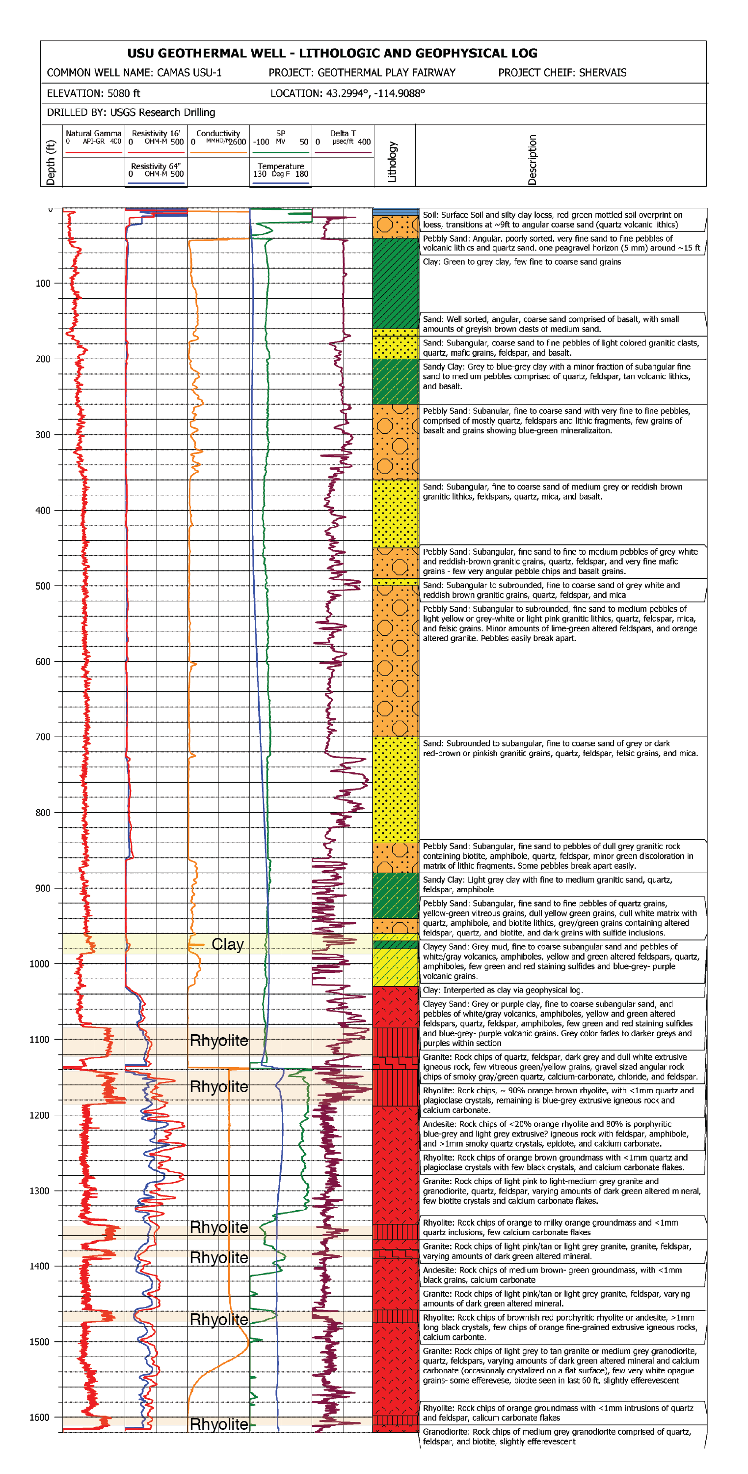
This submission contains documents that describe the USU Camas-1 test well, drilled in Camas Prairie, Idaho, in Fall 2018 and Fall 2019. The purpose of this well is to validate exploration...
Search relevance: 1.00 | Views last month: 0 | Catalog Last Checked: March 23, 2026 at 09:41 PM -
This report details all of the work done in Phase 2 of a geothermal exploration project in Tularosa Basin, New Mexico. Data acquired as part of Phase 2 includes field geology (geological...
Search relevance: 1.00 | Views last month: 0 | Catalog Last Checked: March 23, 2026 at 09:40 PM -
Custom MATLAB and custom GMT scripts for Hawaii Play Fairway Analysis modeling.
Search relevance: 1.00 | Views last month: 0 | Catalog Last Checked: March 23, 2026 at 09:39 PM -
This is a map package that is used to show the wells in New Mexico that may be available for geochemical sampling.
Search relevance: 1.00 | Views last month: 0 | Catalog Last Checked: March 23, 2026 at 09:39 PM -
All datasets and products specific to the Carson Sink Basin. Includes a packed ArcMap (.mpk), individually zipped shapefiles, and a file geodatabase for the Carson Sink area; a GeoSoft Oasis...
Search relevance: 1.00 | Views last month: 0 | Catalog Last Checked: March 23, 2026 at 09:39 PM
