
-
Sub-bottom Profiler Collection for EX1303: New England Seamount Chain Exploration
Knudsen CHIRP 3260 Sub-bottom Profiler raw files (.sgy) -
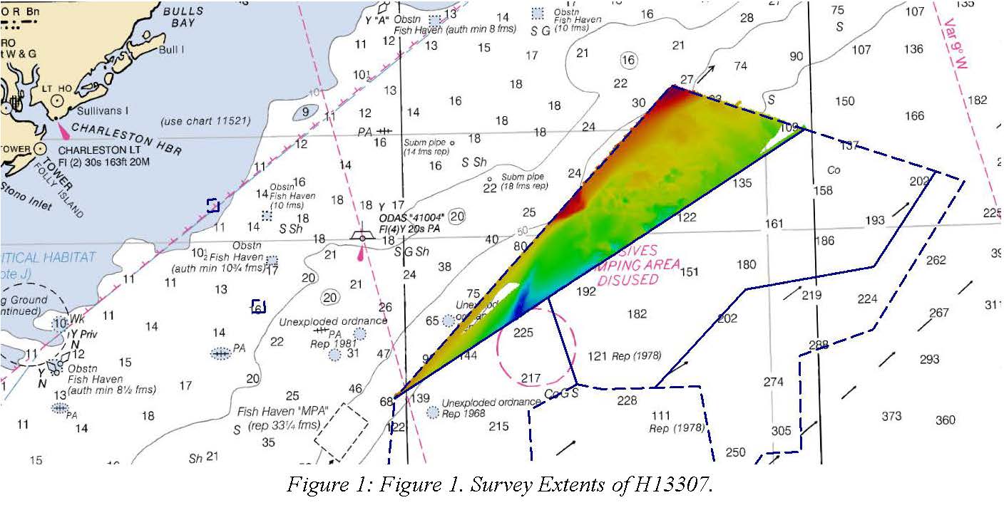
H13307: NOS Hydrographic Survey , 2019-08-30
The National Oceanic and Atmospheric Administration (NOAA) has the statutory mandate to collect hydrographic data in support of nautical chart compilation for safe navigation... -
Ship Track for Estuary to the Abyss 2004: Exploring Along the Latitude 31-30 Transect - Office of Ocean Exploration
Ship track of the R/V Seward Johnson during the "Estuary to the Abyss 2004" expedition sponsored by the National Oceanic and Atmospheric Administration (NOAA) Office of Ocean... -
Subbottom Profiler Collection for EX1403: East Coast Mapping and Exploration
Knudsen CHIRP 3260 Sub-bottom Profiler raw files (.sgy) -
Sub-bottom Profiler Collection for EX1205L1: Exploration, Blake Plateau
Knudsen CHIRP 3260 Sub-bottom Profiler raw files (.sgy) -
EX1302: Ship Shakedown, Patch Test and Exploration, NE Canyons and Seamounts on NOAA Ship Okeanos Explorer between 20130513 and 20130606
Between May 13 and May 18, shakedown operations will: ensure all scientific sonars are in good working order after dry dock operations; assess noise reduction modifications to... -
H13404: NOS Hydrographic Survey , 2020-09-29
The National Oceanic and Atmospheric Administration (NOAA) has the statutory mandate to collect hydrographic data in support of nautical chart compilation for safe navigation... -
Underway physical, meteorological, chemical, and other data collected aboard numerous ships in the NOAA fleet in seas world-wide since February 2012
This collection contains underway physical, meteorological, chemical, and other datasets logged by the Scientific Computer System (SCS) aboard ships in the NOAA fleet in seas... -
EX1303: New England Seamount Chain Exploration on NOAA Ship Okeanos Explorer between 20130611 and 20130629
Transit mapping operations will collect bathymetric, water column backscatter, seafloor backscatter data, and sub-bottom profile data. -
Ship Sensor Observations for Estuary to the Abyss 2004: Exploring Along the Latitude 31-30 Transect - Office of Ocean Exploration
Hourly measurements made by selected ship sensors on the R/V Seward Johnson during the "Estuary to the Abyss 2004" expedition sponsored by the National Oceanic and Atmospheric... -
EX1205L1: Exploration, Blake Plateau on NOAA Ship Okeanos Explorer between 20120705 and 20120724
The EX-12-05 Leg 1 cruise represents a partnership between NOAA Okeanos Explorer Program, National Science Foundation (NSF) and Woods Hole Oceanographic Institution (WHOI) -... -
Sub-bottom Profiler Collection for EX1302: Ship Shakedown, Patch Test and Exploration, NE Canyons and Seamounts
Knudsen CHIRP 3260 Sub-bottom Profiler raw files (.sgy) -
Okeanos Explorer (EX1810): ASPIRE to Map the Extended Continental Shelf
Multibeam, Singlebeam, and Sub-bottom Profile data are the main data outputs. -
W00720: NOS Hydrographic Survey , 2023-05-31
The National Oceanic and Atmospheric Administration (NOAA) has the statutory mandate to collect hydrographic data in support of nautical chart compilation for safe navigation... -
H11071A: NOS Hydrographic Survey , Charleston Bump, South Carolina, 2003-06-21
The National Oceanic and Atmospheric Administration (NOAA) has the statutory mandate to collect hydrographic data in support of nautical chart compilation for safe navigation... -
Sub-bottom Profiler Collection for EX1205L1: Exploration, Blake Plateau
Knudsen CHIRP 3260 Sub-bottom Profiler raw files (.sgy) -
H11680: NOS Hydrographic Survey , Blake Plateau, North Atlantic Ocean, 2007-05-28
The National Oceanic and Atmospheric Administration (NOAA) has the statutory mandate to collect hydrographic data in support of nautical chart compilation for safe navigation... -
Submersible Data (Dive Waypoints) for Estuary to the Abyss 2004: Exploring Along the Latitude 31-30 Transect - Office of Ocean Exploration
Data and information collected by the submersible Johnson Sea-Link II at waypoints along its track during thirteen of the fourteen dives of the 2004 "Estuary to the Abyss"... -
Okeanos Explorer (EX1906): Southeast US and Bahamas, Leg 1 (Mapping)
The cruise will conduct 24 hour/day mapping operations to provide data for EX1907 ROV dive planning.

Official websites use .gov
A
.gov website belongs to an official government
organization in the United States.
Secure .gov websites use HTTPS
A
lock (
) or https:// means you’ve safely connected to
the .gov website. Share sensitive information only on official,
secure websites.
.jpg)