
-
CALIPSO Lidar Level 2 Cloud Profile, V4-20 recent views
CAL_LID_L2_05kmCPro-Standard-V4-20 is the Cloud-Aerosol Lidar and Infrared Pathfinder Satellite Observations (CALIPSO) Lidar Level 2 Cloud Profile, Version 4-20 data product.... -
CALIPSO Lidar Level 1B profile data, V4-10 recent views
CAL_LID_L1-Standard-V4-10 is the Cloud-Aerosol Lidar and Infrared Pathfinder Satellite Observation (CALIPSO) Lidar Level 1B profile data, Version 4-10 data product. This data... -
GEDI L2A Elevation and Height Metrics Data Global Footprint Level V002 recent views
The Global Ecosystem Dynamics Investigation (GEDI) mission aims to characterize ecosystem structure and dynamics to enable radically improved quantification and understanding of... -
CALIPSO Lidar Level 2 5 km Aerosol Layer Data, V4-20 recent views
CAL_LID_L2_05kmALay-Standard-V4-20 is the Cloud-Aerosol Lidar and Infrared Pathfinder Satellite Observation (CALIPSO) Lidar Level 2 5 km Aerosol Layer Data, Version 4-20 data... -
GOES-R PLT Cloud Physics LiDAR (CPL) V1 recent views
The GOES-R PLT Cloud Physics Lidar (CPL) dataset consists of backscatter coefficient, lidar depolarization ratio, layer top/base height, layer type, particulate extinction... -
Polar Winds II - Doppler Aerosol WiNd (DAWN) - DC8 recent views
PolarWindsII_DAWN_DC8_1 is the Polar Winds II - Doppler Aerosol WiNd (DAWN) - DC8 data product. Data collection for this product is complete. Beginning in the fall of 2014, NASA... -
CMS: LiDAR Data for Forested Sites on Borneo Island, Kalimantan, Indonesia, 2014 recent views
This dataset provides airborne LiDAR data collected over 90 sites totaling approximately 100,000 hectares of forested land in Kalimantan, Indonesia on the island of Borneo in... -
CALIPSO Lidar Level 2 5 km Merged Layer, V4-20 recent views
CAL_LID_L2_05kmMLay-Standard-V4-20 is the Cloud-Aerosol Lidar and Infrared Pathfinder Satellite Observations (CALIPSO) Lidar Level 2 5 km Merged Layer, Version 4-20 data... -
CALIPSO Lidar Level 1B profile data, V4-11 recent views
CAL_LID_L1-Standard-V4-11 is the Cloud-Aerosol Lidar and Infrared Pathfinder Satellite Observation (CALIPSO) Lidar Level 1B profile data, Version 4-10 data product. This data... -
CALIPSO Lidar Level 2 5 km Merged Layer, V4-21 recent views
CAL_LID_L2_05kmMLay-Standard-V4-21 is the Cloud-Aerosol Lidar and Infrared Pathfinder Satellite Observations (CALIPSO) Lidar Level 2 5 km Merged Layer, Version 4-21 data... -
CALIPSO Night Validation Flights High Spectral Resolution Lidar (HSRL-2) Data recent views
The CALIPSO Night Validation Flights (CALIPSO-NVF) airborne deployment was conducted in August 2022 out of Bermuda. The goal was to conduct a series of nighttime underflights of... -
CALIPSO Lidar Level 2 1 km Cloud Layer, V4-20 recent views
CAL_LID_L2_01kmCLay-Standard-V4-20 is the Cloud-Aerosol Lidar and Infrared Pathfinder Satellite Observations (CALIPSO) Lidar Level 2 1 km Cloud Layer, Version 4-20 data product.... -
CALIPSO Lidar Level 2 5km Aerosol Profile data, Provisional V3-02 recent views
CAL_LID_L2_05kmAPro-Prov-V3-02 data are Cloud-Aerosol Lidar and Infrared Pathfinder Satellite Observation (CALIPSO) Lidar Level 2 aerosol profile data using the CALIPSO Lidar... -
GEDI L2B Canopy Cover and Vertical Profile Metrics Data Global Footprint Level V002 recent views
The Global Ecosystem Dynamics Investigation (GEDI) ) mission aims to characterize ecosystem structure and dynamics to enable radically improved quantification and understanding... -
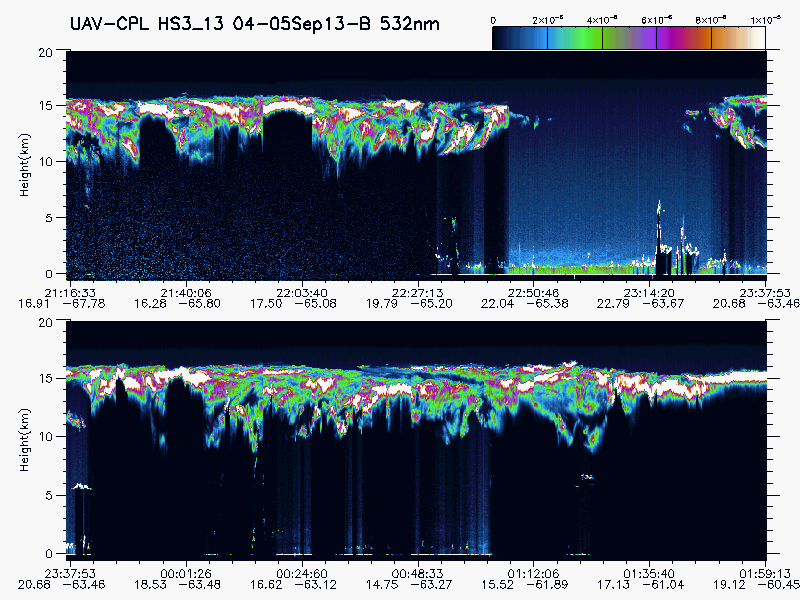
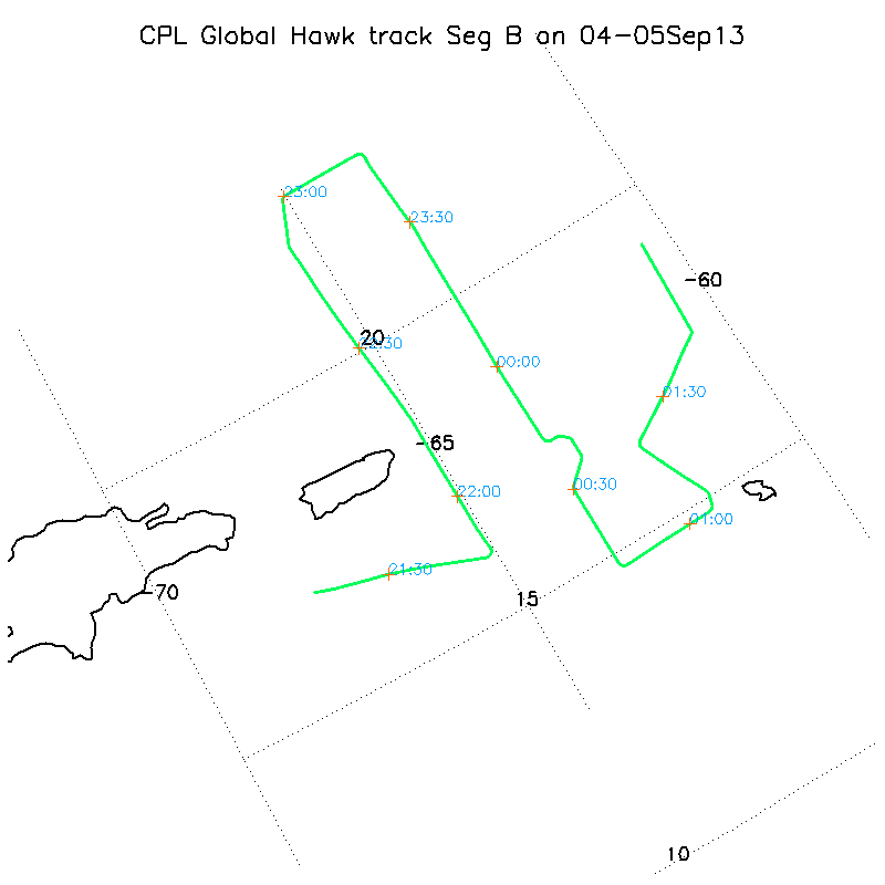
HURRICANE AND SEVERE STORM SENTINEL (HS3) GLOBAL HAWK CLOUD PHYSICS LIDAR (CPL) V1 recent views
The Hurricane and Severe Storm Sentinel (HS3) Global Hawk Cloud Physics Lidar (CPL) dataset includes measurements gathered by the CPL instrument during the HS3 campaign which... -
LiDAR Surveys over Selected Forest Research Sites, Brazilian Amazon, 2008-2018 recent views
This dataset provides the complete catalog of point cloud data collected during LiDAR surveys over selected forest research sites across the Amazon rainforest in Brazil between... -
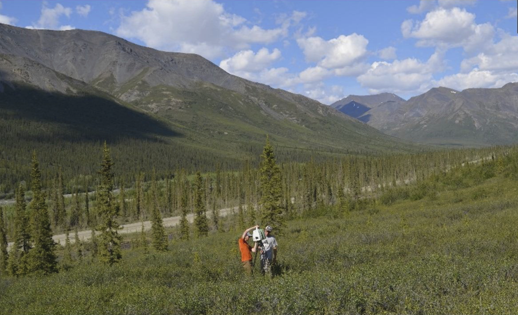
ABoVE: Terrestrial Lidar Scanning Forest-Tundra Ecotone, Brooks Range, Alaska, 2016 recent views
This dataset provides terrestrial lidar scanning (TLS) point cloud data collected at 10 research plots along the forest-tundra ecotone (FTE) in the Brooks Range of Alaska, south...

Official websites use .gov
A
.gov website belongs to an official government
organization in the United States.
Secure .gov websites use HTTPS
A
lock (
) or https:// means you’ve safely connected to
the .gov website. Share sensitive information only on official,
secure websites.