
-
SAFARI 2000 Surface Irradiance Measurements, Mongu Tower Site, Zambia, 2000-2002
This data set contains the top-of-canopy irradiance in the shortwave (0.3-2.8 micron) and photosynthetically active radiation (PAR; 0.4-0.7 micron) wavebands collected with an... -
SeaWiFS Deep Blue Aerosol Optical Thickness Monthly Level 3 Climatology Data Gridded at 1.0 Degrees V004 (SWDB_L3MC10) at GES DISC
The SeaWiFS Deep Blue Level 3 Monthly Climatology Product contains monthly global climatology gridded (1 x 1 deg) data derived from SeaWiFS Deep Blue Level 3 monthly gridded... -
NOAA20 VIIRS+CrIS Fusion 6-Min L2 Swath 750 m
The VIIRS-CrIS Data Fusion Level-2 Product is designed to facilitate improved continuity in derived cloud and moisture products realized with the High Resolution Infrared... -
NASA MEASURES Precipitation Ensemble based on SSMIS DMSP F19 NASA PPS L1C V05 Tbs 1-orbit L2 Swath 12x12km V1 (PRECIP_SSMIS_F19) at GES DISC
The data presented in this level 2 orbital product are rain rate estimates expressed as mm/hour determined from brightness temperatures (Tbs) obtained from the Special Sensor... -
Enhancing Knowledge of the Arabian Sea Marine environment through Science and Advanced Training (EKAMSAT)
Enhancing Knowledge of the Arabian Sea Marine environment through Science and Advanced Training (EKAMSAT) is a collaborative Indo-US field campaign funded by the Ministry of... -
TROPESS Chemical Reanalysis Aerosol NO3 6-Hourly 3-dimensional Product V1 (TRPSCRAERNO36H3D) at GES DISC
The TROPESS Chemical Reanalysis Surface Aerosol NO3 6-Hourly 3-dimensional Product contains the volume mixing rations of nitrate aerosols. The data are part of the Tropospheric... -
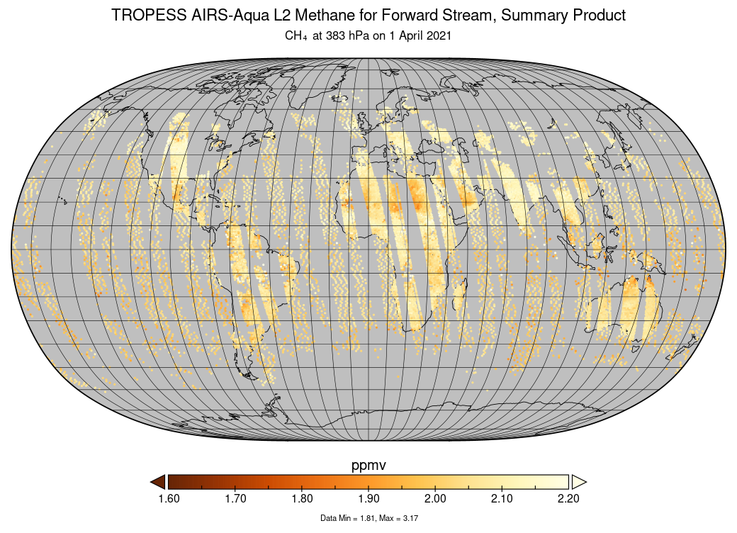
TROPESS CrIS-SNPP L2 Carbon Monoxide for Forward Stream, Summary Product V1 (TRPSYL2COCRSFS) at GES DISC
The TROPESS CrIS-SNPP L2 Carbon Monoxide for Forward Stream, Summary Product contains the vertical distribution of the retrieved atmospheric state of carbon monoxide (CO), and... -
TROPESS OMI-Aura L2 Ozone for Forward Stream, Standard Product V1 (TRPSDL2O3OMIFS) at GES DISC
The TROPESS OMI-Aura L2 Ozone for Forward Stream, Standard Product contains the vertical distribution of the retrieved atmospheric state of ozone (O3), formal uncertainties, and... -
TROPESS Chemical Reanalysis Surface NO2 2-Hourly 2-dimensional Product V1 (TRPSCRNO22H2D) at GES DISC
The TROPESS Chemical Reanalysis NO2 2-Hourly 2-dimensional Product contains surface concentrations of nitrogen dioxide. The data are part of the Tropospheric Chemical Reanalysis... -
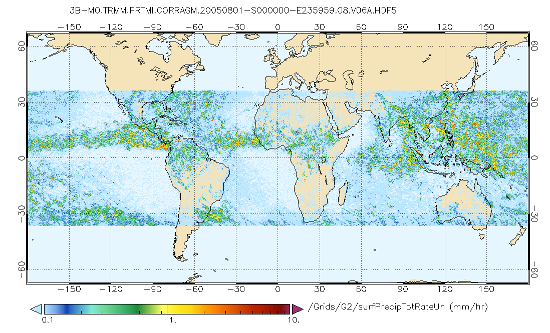
GPM PR on TRMM Echo Power L1B 1.5 hours 5 km V07 (GPM_1BPR) at GES DISC
This is the new (GPM-formated) TRMM product. It replaces the old TRMM_1B21,1C21 Version 07 is the current version of the data set. Previous versions have been superseded by... -
First ISCCP Regional Experiment (FIRE) Extensive Time Observations (ETO) University of Utah Polar Diversification LIDAR
The First ISCCP Regional Experiments have been designed to improve data products and cloud/radiation parameterizations used in general circulation models (GCMs). Specifically,... -
First ISCCP Regional Experiment (FIRE) Atlantic Stratocumulus Transition Experiment (ASTEX) Rawinsonde Level 1 Data
The First ISCCP Regional Experiments (FIRE) have been designed to improve data products and cloud/radiation parameterizations used in general circulation models (GCMs).... -
Delta-X: In-situ Water Surface Elevation, MRD, Louisiana, USA, 2021
This dataset contains in situ water level measurements collected at 49 different locations across the Atchafalaya and Terrebonne basins in the Mississippi River Delta (MRD)... -
MLS/Aura Level 3 Monthly Binned Nitric Acid (HNO3) Mixing Ratio on Assorted Grids V004 (ML3MBHNO3) at GES DISC
ML3MBHNO3 is the EOS Aura Microwave Limb Sounder (MLS) monthly binned on various vertical grids product for nitric acid (HNO3) derived from radiances measured by the 240 GHz... -
MISR radiometric camera-by-camera Cloud Mask subset for the UAE region V004
UAEMIRCM_004 is the Multi-angle Imaging SpectroRadiometer (MISR) radiometric camera-by-camera Cloud Mask subset for the UAE region version 4. It contains the Radiometric camera-... -
INTEX-B DC-8 Aircraft data
INTEX-NA is a two phase experiment that aims to understand the transport and transformation of gases and aerosols on transcontinental/intercontinental scales and assess their... -
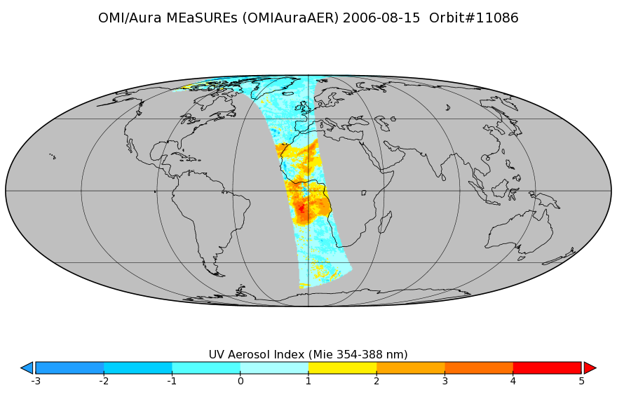
OMI/Aura Near UV Aerosol Index, Optical Depth and Single Scattering Albedo 1-Orbit L2 13x24km
As part of the NASA's Making Earth System Data Records for Use in Research Environments (MEaSUREs) program, this projects describes a multi-decadal Fundamental Climate Data...

Official websites use .gov
A
.gov website belongs to an official government
organization in the United States.
Secure .gov websites use HTTPS
A
lock (
) or https:// means you’ve safely connected to
the .gov website. Share sensitive information only on official,
secure websites.