
-
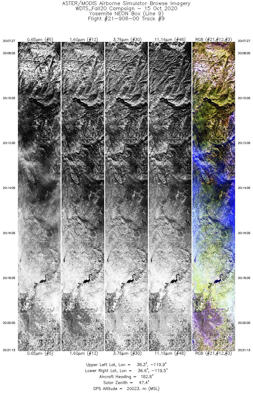
MASTER: Western Diversity Time Series Campaign, WDTS, California, USA, Fall 2020
This dataset includes Level 1B (L1B) and Level 2 (L2) data products from the MODIS/ASTER Airborne Simulator (MASTER) instrument. The spectral data were collected as part of the... -
ISLSCP II Sea Surface Temperature
Sea surface temperature (SST) is an important indicator of the state of the earth climate system as well as a key variable in the coupling between the atmosphere and the ocean.... -
LBA-ECO LC-35 Landsat ETM+ Derived Active Fire Masks, Brazilian Amazon: 2001-2003
This data set provides active fire detection images and associated summary information derived from Landsat 7 Enhanced Thematic Mapper Plus (ETM+) images for various locations... -
INTEX-B DC-8 Aircraft data
INTEX-NA is a two phase experiment that aims to understand the transport and transformation of gases and aerosols on transcontinental/intercontinental scales and assess their... -
March through August Ice Edge Positions in the Nordic Seas, 1750-2002, Version 1
This product contains ice edge coordinates for the Nordic Seas from 1750 through 2002 for months March through August. Ice edge in this product is defined as the outer boundary... -
LRIR/Nimbus-6 Level 2 Inverted Profiles of Temperature and Ozone V001 (LRIRN6L2IPAT) at GES DISC
LRIRN6L2IPAT is the Nimbus-6 Limb Radiance Inversion Radiometer (LRIR) Level 2 Inverted Profiles of Temperature and Ozone data product. The product contains daily profiles of... -
JERS-1 Synthetic Aperture Radar, 100-m Mosaics, South America: 1995-1996, R1
This data set provides ~100-m resolution image mosaics of South America acquired during the low flood season between September and December 1995 and during the high flood season... -
GPM DPR Ku Precipitation Profile 2A 1.5 hours 5 km V07 (GPM_2AKu) at GES DISC
Version 07 is the current version of the data set. Older versions will no longer be available and have been superseded by Version 07. The 2AKu algorithm is a single-frequency... -
GPM ATMS on NOAA-20 (GPROF) Climate-based Radiometer Precipitation Profiling L3 1 day 0.25 degree x 0.25 degree V07 (GPM_3GPROFNOAA20ATMS_DAY_CLIM) at GES DISC
Version 07 is the current version of the data set. Older versions are no longer available and have been superseded by Version 07. The "CLIM" products differ from their "regular"... -
GPM ATMS on NOAA-20 (GPROF) Radiometer Precipitation Profiling L3 1 month 0.25 degree x 0.25 degree V07 (GPM_3GPROFNOAA20ATMS) at GES DISC
Version 07 is the current version of the data set. 3GPROF products provide global gridded monthly/daily precipitation averages from multiple satellites that can be used for... -
GHRSST Level 2P NOAA ACSPO SST v2.80 from VIIRS on NOAA-21 Satellite
The N21-VIIRS-L2P-ACSPO-v2.80 dataset produced by the NOAA ACSPO system derives the Subskin Sea Surface Temperature (SST) from the Visible Infrared Imaging Radiometer Suite... -
GHRSST Level 2P 1 m Depth Global Sea Surface Temperature version 3.0 from the Visible Infrared Imaging Radiometer Suite (VIIRS) on the Suomi NPP satellite (GDS2)
A global Group for High Resolution Sea Surface Temperature (GHRSST) Level 2P dataset based on retrievals from the Visible Infrared Imaging Radiometer Suite (VIIRS). This sensor... -
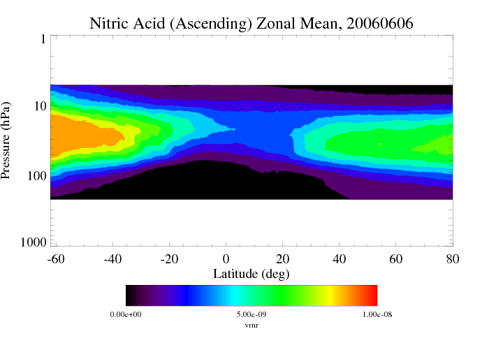
HIRDLS/Aura Level 3 Nitric Acid (HNO3) 1deg Lat Zonal Fourier Coefficients V007 (H3ZFCHNO3) at GES DISC
The "HIRDLS/Aura Level 3 Nitric Acid (HNO3) Zonal Fourier Coefficients" version 7 data product (H3ZFCHNO3) contains the entire mission (~3 years) of HIRDLS data expressed as...

Official websites use .gov
A
.gov website belongs to an official government
organization in the United States.
Secure .gov websites use HTTPS
A
lock (
) or https:// means you’ve safely connected to
the .gov website. Share sensitive information only on official,
secure websites.