
-
LiDAR and DTM Data from Forested Land Near Manaus, Amazonas, Brazil, 2008 recent views
This data set provides LiDAR point clouds and digital terrain models (DTM) from surveys over the K34 tower site in the Cuieiras Biological Reserve, over forest inventory plots... -
GEDI L2A Elevation and Height Metrics Data Global Footprint Level V002 recent views
The Global Ecosystem Dynamics Investigation (GEDI) mission aims to characterize ecosystem structure and dynamics to enable radically improved quantification and understanding of... -
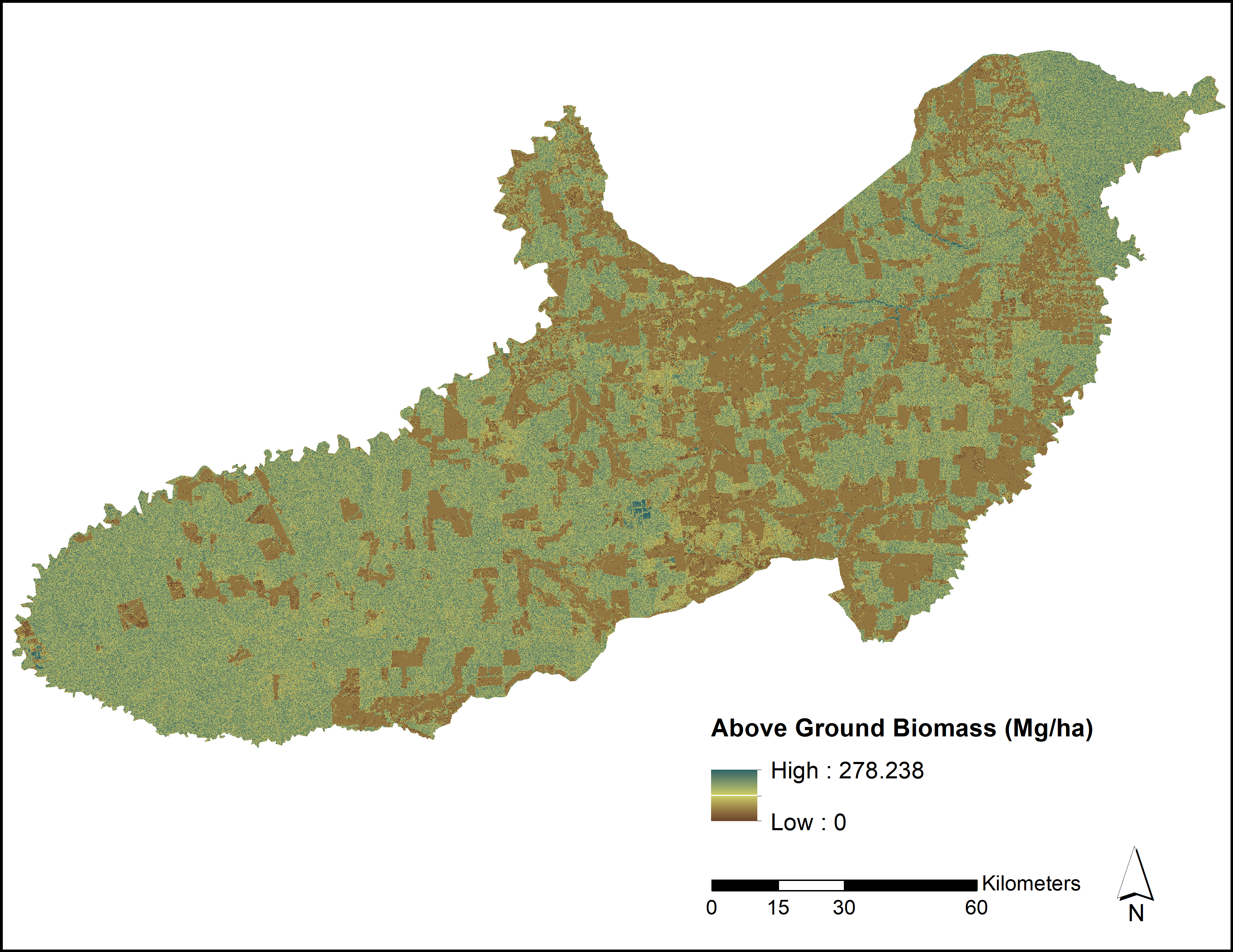
LiDAR and PALSAR-Derived Forest Aboveground Biomass, Paragominas, Para, Brazil, 2012 recent views
This dataset provides estimates of forest aboveground biomass for three study areas and the entire Paragominas municipality, in Para, Brazil, in 2012. Aboveground biomass (in... -
DISCOVER-AQ Maryland Deployment Beltsville Ground Site Data recent views
DISCOVERAQ_Maryland_Ground_Beltsville_Data contains data collected at the Beltsville ground site during the Maryland (Baltimore-Washington) deployment of NASA's DISCOVER-AQ... -
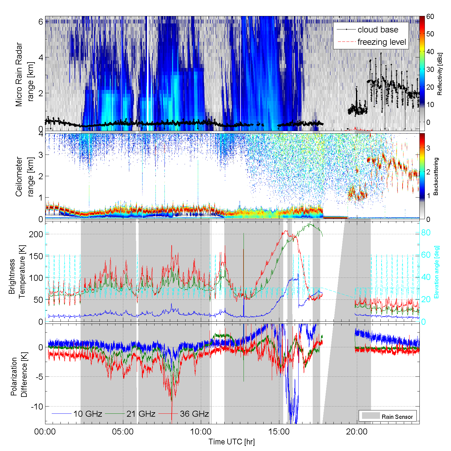
GPM GROUND VALIDATION ADVANCED MICROWAVE RADIOMETER RAIN IDENTIFICATION (ADMIRARI) GCPEX V1 recent views
The GPM Ground Validation Advanced Microwave Radiometer Rain Identification (ADMIRARI) GCPEx dataset measures brightness temperature at three frequencies (10.7, 21.0 and 36.5... -
CALIPSO Lidar Level 2 Vertical Feature Mask (VFM), V4-21 recent views
CAL_LID_L2_VFM-Standard-V4-21 is the Cloud-Aerosol Lidar and Infrared Pathfinder Satellite Observations (CALIPSO) Lidar Level 2 Vertical Feature Mask (VFM), Version 4-21 data... -
DISCOVER-AQ Maryland Deployment Edgewood Ground Site Data recent views
DISCOVERAQ_Maryland_Ground_Edgewood_Data contains data collected at the Edgewood ground site during the Maryland (Baltimore-Washington) deployment of NASA's DISCOVER-AQ field... -
ARCTAS Differential Absorption Lidar (DIAL) Remotely Sensed Data recent views
The Arctic is a critical region in understanding climate change. The responses of the Arctic to environmental perturbations such as warming, pollution, and emissions from forest... -
DISCOVER-AQ Maryland Deployment Essex Ground Site Data recent views
DISCOVERAQ_Maryland_Ground_Essex_Data contains data collected at the Essex ground site during the Maryland (Baltimore-Washington) deployment of NASA's DISCOVER-AQ field study.... -
SOLVE I Ground Site Data recent views
SOLVE1_Ground_Data is the ground site data collected during the SAGE III Ozone Loss and Validation Experiment (SOLVE). Data were collected by instruments such as Differential... -
Disturbance History and Forest Biomass from Landsat for Six US Sites, 1985-2014 recent views
This dataset provides derived disturbance history and predicted annual forest biomass maps at 30-m resolution for six selected Landsat scenes across the Conterminous United... -
CLPX-Airborne: Infrared Orthophotography and Lidar Topographic Mapping, Version 1 recent views
The data set consists of color infrared orthophotography (TerrainVision® - High resolution Topographic Mapping & Aerial Photography, with 6-inch pixel resolution), lidar... -
CALIPSO Lidar Level 2 5 km Cloud Layer, V4-21 recent views
CAL_LID_L2_05kmCLay-Standard-V4-21 is the Cloud-Aerosol Lidar and Infrared Pathfinder Satellite Observations (CALIPSO) Lidar Level 2 5 km Cloud Layer, Version 4-21 data product.... -
DISCOVER-AQ Maryland Deployment UC-12 Aircraft Remotely Sensed High Spectral Resolution Lidar (HSRL) Data recent views
DISCOVERAQ_Maryland_AircraftRemoteSensing_UC12_HSRL_Data contains remotely sensed data collected by the High Spectral Resolution Lidar (HSRL) onboard NASA's UC-12 aircraft... -
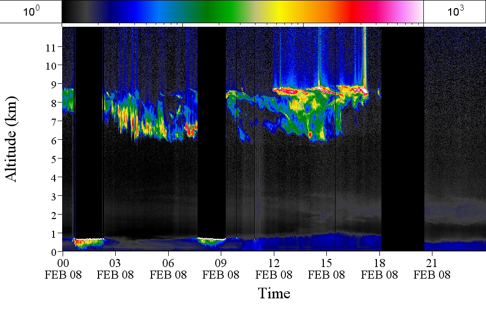
GPM GROUND VALIDATION AEROSOL AND WATER VAPOR LIDAR QUICKLOOKS GCPEX V1 recent views
The GPM Ground Validation Aerosol and Water Vapor Lidar Quicklooks GCPEx dataset contains imagery generated from the GPM Cold-season Precipitation Experiment (GCPEx) campaign...

Official websites use .gov
A
.gov website belongs to an official government
organization in the United States.
Secure .gov websites use HTTPS
A
lock (
) or https:// means you’ve safely connected to
the .gov website. Share sensitive information only on official,
secure websites.