
-
USGS Digital Orthophoto Quadrangles recent views
A Digital Orthophoto Quadrangle (DOQ) is a computer-generated image of an aerial photograph in which the image displacement caused by terrain relief and camera tilt has been... -
Poverty Mapping Project: Poverty and Food Security Case Studies recent views
The Poverty Mapping Project: Poverty and Food Security Case Studies data set consists of small area estimates of poverty, inequality, food security and related measures for... -
Global Change Master Directory (GCMD) recent views
The GCMD database holds more than 30,000 descriptions of Earth science data sets and services covering all aspects of Earth and environmental sciences. The mission of the GCMD... -
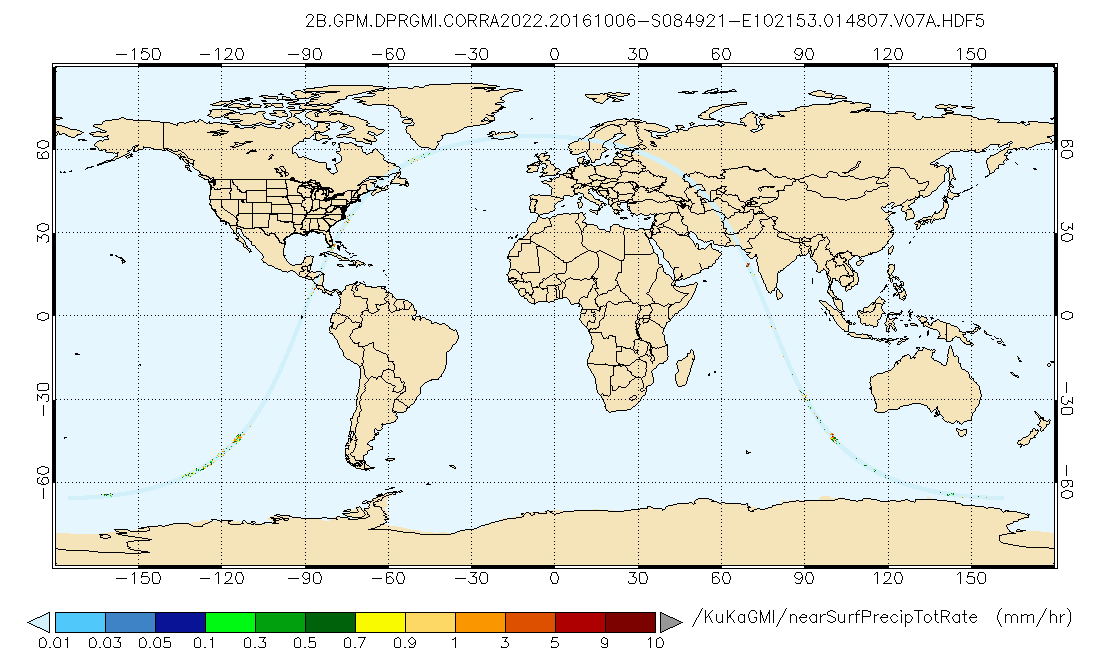
GPM DPR and GMI Combined Precipitation L2B 1.5 hours 5 km V07 (GPM_2BCMB) at GES DISC recent views
Version 07 is the current version of the data set. Older versions will no longer be available and have been superseded by Version 07. This is a precipitation product created... -
NACP Regional: National Greenhouse Gas Inventories and Aggregated Gridded Model Data recent views
This data set provides two products that were derived from the recently published North American Carbon Program (NACP) Regional Synthesis 1-degree terrestrial biosphere model... -
MISR Level 3 Component Global Aerosol Product covering a month V004 recent views
MIL3MAE_4 is the Multi-angle Imaging SpectroRadiometer (MISR) Level 3 Component Global Aerosol Product covering a month version 4. It contains a statistical summary of column... -
MISR Geometric Parameters V003 recent views
MIB2GEOP_003 is the Multi-angle Imaging SpectroRadiometer (MISR) Geometric Parameters Version 3 product. It contains the Geometric Parameters which measure the sun and view... -
TROPICS07 L2A Unified Resolution Brightness Temperatures V0.2 recent views
The "Time-Resolved Observations of Precipitation structure and storm Intensity with a Constellation of Smallsats" (TROPICS) mission has a goal of providing nearly all-weather... -
CERES Energy Balanced and Filled (EBAF) TOA Monthly means data in netCDF Edition4.2 recent views
CERES_EBAF-TOA_Edition4.2 is the Clouds and the Earth's Radiant Energy System (CERES) Energy Balanced and Filled (EBAF) Top-of-Atmosphere (TOA) Monthly means data in netCDF... -
Annual Summary of Artificial Light At Night from VIIRS/S-NPP at CONUS County and Census Tract V1 (ALAN_VIIRS_CONUS) at GES DISC recent views
This product provides detailed information about the satellite-based data on artificial light at night (ALAN). The Suomi National Polar-orbiting Partnership (S-NPP) Visible... -
Aqua/AIRS L2 Standard Physical Retrieval (AIRS+AMSU) V7.0 at GES DISC recent views
The Atmospheric Infrared Sounder (AIRS) is a grating spectrometer (R = 1200) aboard the second Earth Observing System (EOS) polar-orbiting platform, EOS Aqua. The AIRS... -
TRMM Precipitation Radar Rain Characteristics L2 1.5 hours V7 (TRMM_2A23) at GES DISC recent views
The new version of these data is in GPM-like format (consistent with the GPM Dual-frequency Radar data format), and can be found under the name GPM_2APR. The TRMM Precipitation... -
GHRSST Level 4 MUR Global Foundation Sea Surface Temperature Analysis (v4.1) NGDA recent views
A Group for High Resolution Sea Surface Temperature (GHRSST) Level 4 sea surface temperature analysis produced as a retrospective dataset (four day latency) and near-real-time... -
GPCP Precipitation Level 3 Monthly 0.5-Degree V3.2 (GPCPMON) at GES DISC recent views
Version 3.2 is the current version. Older versions have been superseded by Version 3.2. The Global Precipitation Climatology Project (GPCP) is the precipitation component of an... -
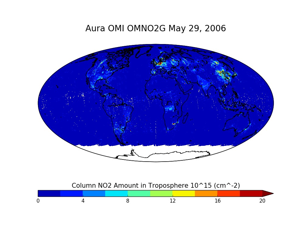
OMI/Aura NO2 Total and Tropospheric Column Daily L2 Global Gridded 0.25 degree x 0.25 degree V3 (OMNO2G) at GES DISC recent views
This Level-2G daily global gridded product OMNO2G is based on the pixel level OMI Level-2 NO2 product OMNO2. OMNO2G data product is a special Level-2 Gridded Product where pixel... -
OCO-2 GEOS Level 3 daily, 0.5x0.625 assimilated CO2 V10r (OCO2_GEOS_L3CO2_DAY) at GES DISC recent views
This is the Gridded Daily OCO-2 Carbon Dioxide assimilated dataset. The OCO-2 mission provides the highest quality space-based XCO2 retrievals to date. However, the instrument... -
Global Maps of Atmospheric Nitrogen Deposition, 1860, 1993, and 2050 recent views
This data set provides global gridded estimates of atmospheric deposition of total inorganic nitrogen (N), NHx (NH3 and NH4+), and NOy (all oxidized forms of nitrogen other than... -
AMSR2/GCOM-W1 surface soil moisture (LPRM) L3 1 day 25 km x 25 km descending V001 (LPRM_AMSR2_D_SOILM3) at GES DISC recent views
AMSR2/GCOM-W1 surface soil moisture (LPRM) L3 1 day 25 km x 25 km descending V001 is a Level 3 (gridded) data set. Its land surface parameters, surface soil moisture, land... -
Global Vegetation Greenness (NDVI) from AVHRR GIMMS-3G+, 1981-2022 recent views
This dataset holds the Global Inventory Modeling and Mapping Studies-3rd Generation V1.2 (GIMMS-3G+) data for the Normalized Difference Vegetation Index (NDVI). NDVI was based... -
LBA-ECO ND-06 Land Use Effects on Soil Nutrients: A Review of Studies 1950-2001 recent views
This data set provides measurements of soil properties compiled from 39 studies on nutrient dynamics in natural forests and forest-derived land uses (pasture, shifting...

Official websites use .gov
A
.gov website belongs to an official government
organization in the United States.
Secure .gov websites use HTTPS
A
lock (
) or https:// means you’ve safely connected to
the .gov website. Share sensitive information only on official,
secure websites.