
-
Sentinel-6 NASA/JPL GNSS-RO Non-Time-Critical Level 1B V1 (S6A_RO_1B_NTC_NC__) at GES DISC
This dataset provides the L1B Global Navigation Satellite System (GNSS) Radio-Occultation (RO) Non-Time-Critical (NTC) retrieval generated by NASA's Jet Propulsion Laboratory... -
SOLVE I DC-8 Analysis Model Data
SOLVE1_Analysis_DC8_Data contains modeled trajectories and meteorological data along the flight path for the DC-8 aircraft collected during the SAGE III Ozone Loss and... -
Global Population Density Grid Time Series Estimates
The Global Population Density Grid Time Series Estimates provide a back-cast time series of population density grids based on the year 2000 population grid from SEDAC's Global... -
Low Elevation Coastal Zone (LECZ) Global Delta Urban-Rural Population and Land Area Estimates, Version 1
The Low Elevation Coastal Zone (LECZ) Global Delta Urban-Rural Population and Land Area Estimates, Version 1 data set provides country-level estimates of urban, quasi-urban,... -
Declassified Satellite Imagery 2 (2002)
Declassified satellite images provide an important worldwide record of land-surface change. With the success of the first release of classified satellite photography in 1995,... -
EMIT L1B Corrected Spacecraft Attitude and Ephemeris V001
The Earth Surface Mineral Dust Source Investigation (EMIT) instrument measures surface mineralogy, targeting the Earth’s arid dust source regions. EMIT is installed on the... -
Milky Way Star Clusters Catalog
Although they are the main constituents of the Galactic disk population, for half of the open clusters in the Milky Way reported in the literature nothing is known except the... -
Sea Ice Trends and Climatologies from SMMR and SSM/I-SSMIS, Version 3
NSIDC provides this data set to aid investigations of variability and trends in sea ice cover. Ice cover in these data are indicated by sea ice concentration: the percentage of... -
Gridded Population of the World, Version 4 (GPWv4): Population Density, Revision 11
The Gridded Population of the World, Version 4 (GPWv4): Population Density, Revision 11 consists of estimates of human population density (number of persons per square... -
PEM Tropics B P-3B Trajectory Data
PEM-Tropics-B_Trajectory_P3B_Data is the trajectory data collected onboard the P-3B aircraft during the Pacific Exploratory Mission (PEM) Tropics B suborbital campaign. Data... -
MODIS/Terra+Aqua Land Cover Type Yearly L3 Global 500m SIN Grid V006
The MCD12Q1 Version 6 data product was decommissioned on July 31, 2023. Users are encouraged to use the MCD12Q1 Version... -
Goddard Earth Sciences Data and Information Services Center (GES DISC)
The NASA Goddard Earth Sciences (GES) Data and Information Services Center (DISC) is the home (archive) of Precipitation, Atmospheric Chemistry and Dynamics, and information, as... -
NACP Integrated Wildland and Cropland 30-m Fuel Characteristics Map, U.S.A., 2010
The data set provides a 30-m comprehensive fuelbed characteristics map for both the wildland and cropland areas of the conterminous United States (CONUS) for 2010. This... -
WorldView-3 Level 1B Multispectral 8-Band Satellite Imagery
The WorldView-3 Level 1B Multispectral 8-Band Imagery collection contains satellite imagery acquired from Maxar Technologies (formerly known as DigitalGlobe) by the Commercial... -
Geocryology and Geocryological Zonation of Mongolia, Version 1
The map of Geocryology and Geocryological Zonation of Mongolia was derived from the National Atlas of Mongolia (Sodnom and Yanshin, 1990). The data set depicts the distribution... -
Earth Radiation Budget Experiment (ERBE) Regional, Zonal, and Global Averages S-4 data in native format
ERBE_S4_NAT_1 is the Earth Radiation Budget Experiment (ERBE) Regional, Zonal, and Global Averages S-4 data in native format data set, which contains space and time averages of... -
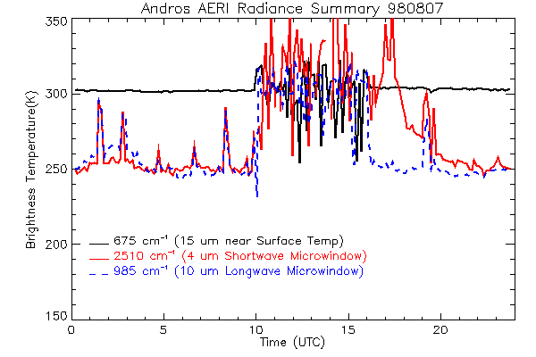
CAMEX-3 ATMOSPHERIC EMITTED RADIANCE INTERFEROMETER (AERI) V1
The Atmospheric Emitted Radiance Interferometer (AERI) was used to make atmospheric temperature and moisture retrievals. AERI provides absolutely calibrated radiances which can...

Official websites use .gov
A
.gov website belongs to an official government
organization in the United States.
Secure .gov websites use HTTPS
A
lock (
) or https:// means you’ve safely connected to
the .gov website. Share sensitive information only on official,
secure websites.